All Activity
- Past hour
-
Yes, the was some sun I bet in CT, but mostly cloudy overall in SNE. I noted that day in Woburn it was breezy and a thick high OVC by early afternoon. I went up to U Lowell to monitor the radar, and then noted the monster cell W of ALB. My drive from Lowell to HFD was OVC the entire time. Did not make it to HVN in time and I was just ahead of the MA tornadic supercell moving SE from Hubbardston, but I had no idea there was tornadic there (it formed rapidly after I left Lowell) b/c the VIS sucked! Even though in the HFD area missed the monster supercell, other cells hit the area, and one a drove though, I have never seen it get so dark approaching any storm in New England. The LTG was not crazy, but did it pour!
-
yeah I turned it on this morning simply so it wouldn't have to work hard later to cool it down
-
I remember reading some accounts that the sun broke out maybe an hour or two prior to the cell moving north through the valley from Long Island and that may have been enough to rapidly destabilize things. There definitely had to be some localized horizontal vorticity in which the rapid destabilization was enough to tilt this more vertically and become ingested into the updraft.
-

2025-2026 ENSO
michsnowfreak replied to 40/70 Benchmark's topic in Weather Forecasting and Discussion
Forecasting a DJF average of milder than average is a no brainer for the northern tier of a strong Nino, but precip/snow is always a wildcard. As Chuck has pointed out, often the strong the el nino, the higher probability of a wetter outcome in areas like the Lakes where the generic El nino map would show dry. -

2026-2027 Super El Nino
bluewave replied to Stormchaserchuck1's topic in Weather Forecasting and Discussion
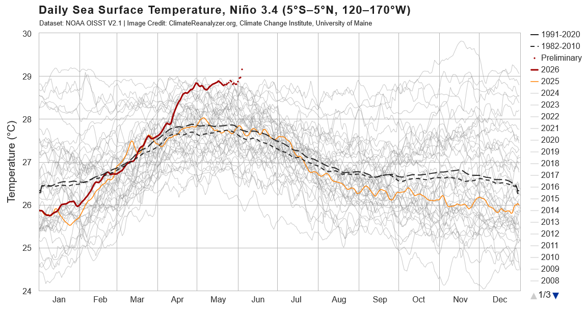
Record breaking WWB for this time of year driving those record Nino 3.4 SSTs. -
CoastalWx "mad" b/c the SLGT stops just short of Weymouth! LOL.
-
Oct 1979 was an odd duck. Not sure of the left movement as a factor. Maybe more CT Valley localized SRH enhancement and pure dynamics. It was right at the triple point occlusion, almost a like light version of the 1925 Tri-State Tor when the supercell followed closely the sfc low. This also occurred in NC/SC on 3/28/1984. Supercell was closely associated w/ a 980 mb sfc low and produced 15 tors, 7 that were F4! Reanalysis fcst using hires models presented at the SNE conference in ORH some 20 years ago noted that nothing stood out as any real tor potential for the 10/3/1979 event. It was the only tor and supercell, and no other svr wx reports in SNE that day outside that one cell. They also did reanalysis of 6/9/1953, and of course that stood out no problem. The BDL tor did $250M in damages. Adjusted for inflation, that would be $1.1B today. That makes it the costliest tor in New England history. At the time, the BDL F4 was the third costliest U.S. tor on record w/ the $400M at #1 from the SPS F4 in April that year and #2 Xenia OH F5 in April 1974. ORH tor in 1953 adjusted for inflation would be $658M, but in the 1953, the $53M in damages was the costliest U.S. tor up to that time.
-

2026-2027 Super El Nino
chubbs replied to Stormchaserchuck1's topic in Weather Forecasting and Discussion
The recent spike has sent daily Nino 3.4 temps well into record territory.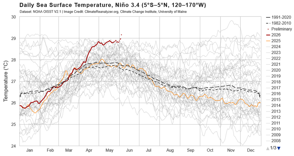
-

2026-2027 Super El Nino
Stormchaserchuck1 replied to Stormchaserchuck1's topic in Weather Forecasting and Discussion
^You were right about the lagged warming after the SOI. -
Tomorrow evening could be interesting near the northern parts of the LWX CWA
-
-
ahhh right...the Oct 79 was left moving
-

2026-2027 Super El Nino
GaWx replied to Stormchaserchuck1's topic in Weather Forecasting and Discussion
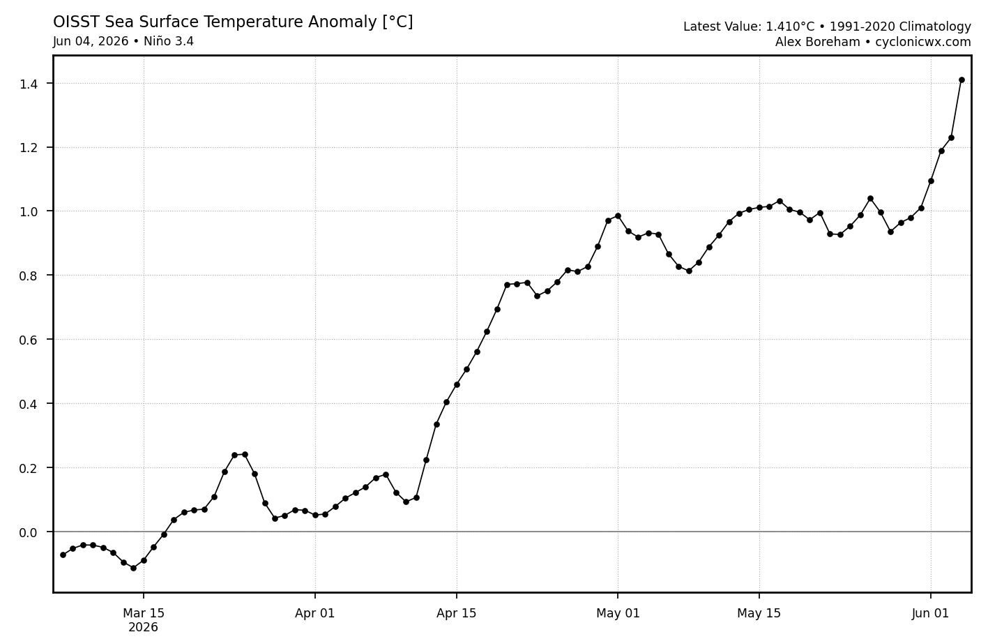
Wow! The latest update for OISST (June 4th) has a massive warming for one day: 0.189C! That’s the strongest one day warming since way back on March 6th! The last 4 days have warmed a hair over 0.4C or a whopping 0.1C/day! That’s the fastest 4 day warming on this entire chart, even exceeding the ~0.36C of April 11th-15th. See far right side of the image below. The strong -SOI is doing its magic on its typically couple of week delayed basis vs when the strong negative string started. This means the 6/5/26 RONI equivalent daily is already up to the +0.8 to +0.9 range! Implications for Monday’s weekly 3.4 update: at the very least an increase of 0.2C to 0.7C relative 3.4. There’s a good shot at an increase of 0.3 to 0.8 relative 3.4 if this continues to rise on the next 2 days’ updates: Check out today’s and last 4 days’ warming!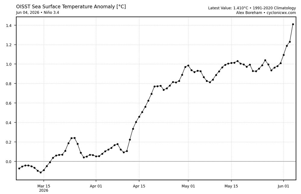
-
has anyone else noticed an absence of mosquitos
-
Maybe biased a little extreme, but the Euro is legit seasonal model.
-
so far 95.5
-

Pittsburgh PA Summer 2026 Thread
TheClimateChanger replied to TheClimateChanger's topic in Upstate New York/Pennsylvania
I didn't see anyone mention, but it was an incredible spring here for western Pennsylvania standards. The average high of 65.7°F ranked as 4th warmest on record for meteorological spring behind only 2012, 2024 & 1921. Incredibly, each of the last three springs are among the 8th warmest (by average daily high) in the entire threaded record! Wow! -
Pittsburgh PA Summer 2026 Thread
TheClimateChanger replied to TheClimateChanger's topic in Upstate New York/Pennsylvania
After a relatively cooler start to the month, it looks like temperatures should be decidedly warmer than normal for much of the next two weeks. Here are the European ensemble means and spreads for highs & lows at Allegheny County Airport. Looks like great pool weather coming up. - Today
-

E PA/NJ/DE Spring 2026 Obs/Discussion
Hurricane Agnes replied to PhiEaglesfan712's topic in Philadelphia Region
Tapped 90 for the first time this month about 45 minutes ago, my 5th 90 or above temp for the year so far. Just missed it yesterday when I didn't get past 89. After a 65 low this morning, it's currently sunny and 89 with dp 60. -
Summer is here!
-
You mean "right-moving!"
-
84° , which is hot for here.
-
I would say the more positive the better, main effect of PDO is PNA/EPO which the stronger they go, they stronger our troughs are here on the East Coast. The PDO has steep incline to Winter effect the further in the year you go. Here's the lagged correlation: So Fall PDO is like 2x more important than Spring PDO.
-
87F with a slight breeze. My house is boiling. Had the ac cranking this morning when I got home from work turned it off huge mistake. Now its struggling to get cool in here with 13 foot ceilings. 78 in the house.
-

2026-2027 Super El Nino
LakePaste25 replied to Stormchaserchuck1's topic in Weather Forecasting and Discussion
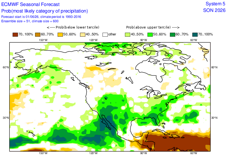
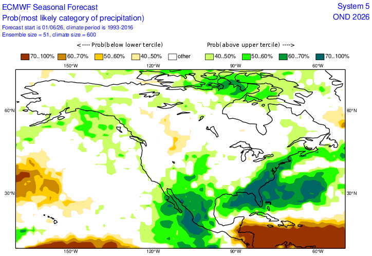
Latest Euro seasonal gets the enhanced coastal precipitation going as early as September.