All Activity
- Past hour
-

2025 Short Range Severe Weather Discussion
A-L-E-K replied to Chicago Storm's topic in Lakes/Ohio Valley
at least it feels juiced, time to wait and see how timing and clouds play out -
 We'll see how low these go over the next 14 days Aug dep through 8/17 EWR: +0 NYC: -0.2 JFK: -0.9 LGA: -1.0
 -
Not much variability with this one..well modeled.
-
Records: Highs: EWR: 97 (2002) NYC: 94 (2002) LGA: 95 (2002) JFK: 93 (1995) Lows: EWR: 52 (1941) NYC: 55 (1915) LGA: 59 (1941) JFK: 58 (1963) Historical: 1779: William Dunbar observed and wrote about the passage of a hurricane's eye over New Orleans. (Ref. AccWeather Weather History) 1879: This storm is often called "The Cape Cod Hurricane of 1879" An extreme hurricane moved north and went on the rampage from the Bahamas to Eastport, Maine (track to the right). In the immediate Mid-Atlantic region, the track of this storm ran very close to a Wilmington - Elizabeth City, NC axis to just southeast of Norfolk. It was considered one of the most severe to strike coastal Virginia in the last half century and was probably as severe as the June 1825 storm. The passage of this storm was accompanied by a rapid pressure fall from 29.58 inches at 9:00 am to 29.12 inches at 11:15 am on the 18th, which was the lowest pressure observed in the storm. Five-minute sustained winds rose to 76 mph with gusts toward 100 mph at Cape Henry, before the anemometer was destroyed. (Ref. for 1879 Hurricane) 1906: Unusual tropical storm came up into the Gulf of California, giving Needles, California 5.66 inches of rain, twice what would normally be seen in a year. (Ref. AccWeather Weather History) 1909: Bagdad, in San Bernardino County of California, reported no precipitation for 993 consecutive days from this date to 5/6/1912. (Ref. Wilson Wx. History) 1917: The high temperature in Death Valley, CA was 119°. This ended a record streak of 43 consecutive days with the high temperature 120° or hotter. (Ref. Wilson Wx. History) 1925 - During the late morning hours a severe hailstorm struck southeastern Iowa completely destroying crops along a path six to ten miles wide and 75 miles long. The hail also injured and killed poultry and livestock, and caused a total of 2.5 million dollars damage. The hailstorm flattened fields of corn to such an extent that many had to leave their farms in search of other work. It was one of the worst hailstorms of record for the nation. (The Weather Channel) 1936: An average of the temperatures at 113 reporting stations in Iowa measured 106.5°, making this the hottest day in the state's history as of this date. (Ref. AccWeather Weather History) 1943: Autumn was in the air with record low temperatures of 41° at Grand Rapids, MI and 43° at Muskegon, MI. (Ref. Wilson Wx. History) 1953: Four heifers near St. Martin, MN were lucky. A tornado picked them up and set them back down again, unharmed. (Ref. AccWeather Weather History) 1955: Diane crossed MD gave 1.09 inches of rain on 18th & brought flooding because of the heavy rain by the earlier storm Connie. Hurricane Diane became the second hurricane to strike the United States East Coast in less than a week. Diane weakened as it crossed colder water left in the wake of Hurricane Connie, but the rainfall did not diminish. The storm moved across the North Carolina coast then recurved to the northeast, passing very near Philadelphia, PA then to the southern coast of New England. Diane's heavy rains, up to 13 inches in the Poconos, added to those of Connie 5 days earlier, brought massive flooding to the Mid Atlantic and the northeast. Westfield, MA recorded 18.15 inches of rain in just 24 hours to establish the 24 hour mark for the state. Boston, MA had 8.40 inches, their greatest 24 hour total ever. At one point, 40% of Worcester, MA was under water. Up to 200 people were killed with $800 million dollars in damage.(Ref. AccWeather Weather History) (The Weather Channel) (More Information About Diane) Diane's Storm Track - NOAA. Gov. - National Hurricane Center 1980: Three inches of snow fell at McCall, ID, a sign of the changing seasons. (Ref. AccWeather Weather History) 1983 - Hurricane Alicia ravaged southeastern Texas. The hurricane caused more than three billion dollars property damage, making it one of the costliest hurricanes in the history of the U.S. Just thirteen persons were killed, but 1800 others were injured. The hurricane packed winds to 130 mph as it crossed Galveston Island, and spawned twenty-two tornadoes in less than 24 hours as it made landfall. (The Weather Channel) (Storm Data) 1987 - Thirteen cities in the eastern U.S. reported record high temperatures for the date, including Orlando FL with a reading of 98 degrees, and Portland ME with a high of 94 degrees. Newark NJ reached 90 degrees for the thirty-sixth time of the year, their second highest total of record. (The National Weather Summary) 1988 - Twenty-two cities, from the Carolinas to the Upper Ohio Valley, reported record high temperatures for the date, pushing the total number of daily record highs since the first of June above the 1100 mark. Afternoon highs of 102 degrees at Greensboro NC and 105 degrees at Raleigh NC equalled all-time records. Evening thunderstorms in Montana produced wind gusts to 75 mph at Scobey. (The National Weather Summary) (Storm Data) 1989 - Thunderstorms over the Middle Atlantic Coast Region and the Upper Ohio Valley produced torrential rains in eastern Virginia during the late morning and afternoon hours. Totals ranged up to twelve inches at Yorktown. Williamsburg VA was deluged with 10.78 inches of rain between 6 AM and 10 AM, with 6.72 inches reported in just two hours. Flash flooding caused nearly twelve million dollars damage in Accomack County VA. Early evening thunderstorms in the Central High Plains Region produced walnut size hail and wind gusts to 80 mph around Casper WY. Thunderstorms produced locally heavy rains in the Yellowstone Park area, causing fifteen mudslides. (The National Weather Summary) (Storm Data) 1993: A squall line developed across western Iowa sending damaging winds over the west central portion of the state for a brief time. A tornado touched down west of Breda causing extensive damage to a farmstead and minor damage to another. Also, an 80 foot barn was destroyed by the tornado. High winds from the storm also overturned a tractor semi-trailer north of Carroll and caused extensive crop damage in the area. (Ref. Wilson Wx. History) 1994: Residents who were in the path of the 1994 Lahoma storm in Oklahoma, awoke on this morning to find a strange world. The devastating wind and hail storm on the previous day had stripped nearly every tree of leaves in the Lahoma and Drummond areas. That, along with plowed fields from harvested wheat, left the August landscape looking eerily more like mid winter. Hail was still on the ground in some protected areas around Lahoma more than 24 hours after the storm. (Ref. Wilson Wx. History) 2005: 27 tornadoes were documented in WI today, thus establishing its record for the greatest number of tornadoes reported in a calendar day. Most were F0 or F1, but an F3 storm killed 1, hurt 23 between Fitchburg and Rockdale. 4 other injuries reported. (Weather Guide Calendar with Phenomenal Weather Events 2011 Accord Pub. 2010, USA) (More Information About These Storms) 2008: During seven days in Florida, August 18–24, 2008, eleven people died and thousands of homes plus roads were damaged, from 60 mph winds and flooded rivers or tornadoes, as Fay traveled through the entire state. Fay was the first storm on record to hit the same U.S. state on four separate occasions, beating a record set by Hurricane Gordon of 1994, It was just the third storm on record to hit the U.S. at least 3 times. Fay was also the first storm to prompt storm warnings for the entire coast of Florida. The four separate landfalls were responsible for every stretch of the Florida coast to receive a Tropical Storm Watch or Warning, or a Hurricane Watch or Warning. The two highest rainfall amounts recorded were 27.65 inches at Windover Farms, 8 miles northwest of Melbourne, Florida, and 27.50 inches at Thomasville, Georgia. The amount of total insured damage compiled by the Property Claim Services of the Insurance Services Office, Inc., was $245 million dollars. This includes $195 million in Florida, $25 million in Georgia, and $25 million in Alabama. Flood damage losses reported by the National Flood Insurance Program were about $36 million dollars. Using a doubling of insured losses to obtain the total damage gives an estimate of Fay’s damage in the United States of about $560 million dollars. Fay's Storm Track - Weather Underground (More Information About Hurricane Fay) (Ref. WxDoctor)
-
As a sweeping generality, -ENSO/-PDO winters tip their hand in November and December….if those 2 months are warmer than normal with below average snow, that usually sets the tone for the remainder of the winter season….the opposite (colder than normal with above average snow) normally also holds true
-

NEW DISTURBANCE: Central Tropical Atlantic (0/50)
WxWatcher007 replied to BarryStantonGBP's topic in Tropical Headquarters
I'm skeptical that this wave gets pushed into the Gulf given the signal for another big trough on the ensembles, but critically, this trough is more over the US rather than in Canada, which opens the door for some type of east coast threat. We obviously have a long way to go with this one, but it's worth some attention. -

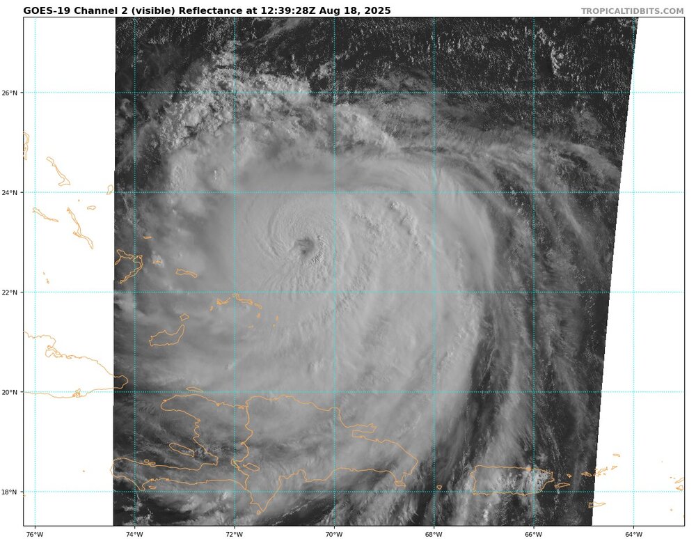
Hurricane Erin: 130 MPH - 942mb - NW @ 12
WestBabylonWeather replied to BarryStantonGBP's topic in Tropical Headquarters
Surfers dream comin up -
Erin is not going to need to hug the coast in order to bring some impacts. This is going to be a huge wind field, and if Erin is truly poised to continue tracking further west as it has throughout its time being forecasted, strong winds along the coast shouldn't be ruled out. The NHC itself has made it a point in recent discussions. We should also start keeping an eye on what the ensembles do with the follow up wave.
-
 I hope we stay at these temps all day
 -
Hurricane Erin: 130 MPH - 942mb - NW @ 12
WxWatcher007 replied to BarryStantonGBP's topic in Tropical Headquarters
Yeah, there's no question this has been further south/west of guidance throughout its life cycle. Given the size that it will acquire, it won't need to be hugging the coast to bring TS impacts to the Outer Banks and maybe even far SE New England and the Canadian Maritimes. This one may not make landfall, but its impact is being felt in many places. -

2025 Short Range Severe Weather Discussion
CheeselandSkies replied to Chicago Storm's topic in Lakes/Ohio Valley
13Z slight risk upgrade with the addition of a 2% tornado contour is giving me deja vu on this 20th anniversary. Overcast here in Madison, and the additional rain pushing in from Iowa doesn't lend confidence in clearing anytime soon, but satellite does show clearing in northern IL and nosing into far southern WI. That line in Iowa looks to be flying though so we may yet clear out around midday. Will have to see where the outflow and differential heating boundaries end up. -
 A cooler regime is now in place and it will remain in place for an extended period of time. Here's where things currently stand with respect to select high temperature thresholds for 2025:
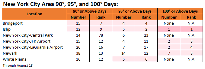
-
Now there's a lot more nuance to this obviously as we have to see 1) whether the wave develops, 2) where it develops, 3) when it develops, but unlike Erin, for an ensemble 7 days out and not 10+, this is an "in the ballgame" look. EPS is more paltry but that's how the EPS/Euro is--look at the lows buried in the Bahamas. GEFS show something similar. Just as important is the 500mb pattern. Storms in the Bahamas don't matter if you don't have an Atlantic ridge to block and trough to our west to pull it north. Again, this is about 7 days out on the ensembles, so this isn't a fantasy steering pattern scenario. This is Erin at 72h. Everyone by now should know this is NOT a NE tropical pattern. Not even close with that depiction in Canada. Now look at the pattern in about a week as this possible wave approaches the Bahamas. Still work to do with the trough, but it's night and day with a ridge building in the maritimes. Verbatim that's not a lock for us, but what is at this range. The players on the table however show that this one is worth a closer eye.
-
67 / 56 and the coolest - cloudiest day (as a whole) since Aug 1st with the NE / ENE flow and cloud bank socked and locked in. Low 70s today and maybe some glimmers of sun later on - stiff breeze. Mainly 70s Tue / Wed with some 80 / low 80s inland. Erin goes on by with some heavy surf and scattered showers Wed-Thu. Warmup by Friday and this coming weekend, before trough settles in next Monday. Ridge builds east and heights rising the close of the month with the next chance at some heat wit overall warm-hot beyond. 8/18 - 8/21 : Cooler below normal - scattered rain Wed/Thu 8/22 - 8/24 : Warmer - near normal 8/25 - 8/29: Cooler / Wetter overall 8/30 - BeYond : Warm - hot
-
Ended up at .64 at the farm in Fallston from that storm last night. Really needed too.
-
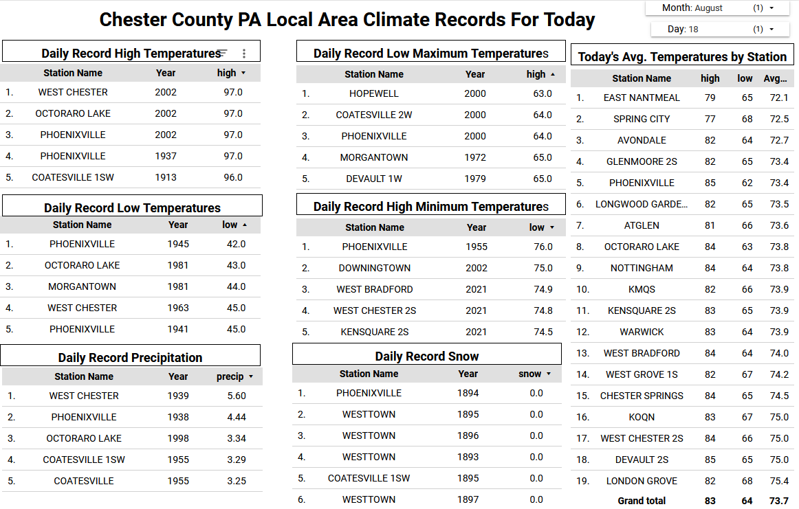
Most of the rain last evening missed our area to the south and east toward Philadelphia and NJ. It’s much cooler today and quite breezy. Today’s temperatures will struggle to rise much, and I suspect some of the higher ridge locations may not escape the 60's for high temperatures. Below normal temperatures continue through mid-week before we moderate to close to about normal for late August. A few sprinkles are possible today and again Wednesday night but unfortunately another dry week in our future. Most spots in Chester County have seen less than 0.10" of rain so far here in August. No impacts back here in Chester County from Hurricane Erin...but coastal flooding and beach erosion will be an issue for the Jersey Shore.

-

E PA/NJ/DE Summer 2025 Obs/Discussion
ChescoWx replied to Hurricane Agnes's topic in Philadelphia Region
Most of the rain last evening missed our area to the south and east toward Philadelphia and NJ. It’s much cooler today and quite breezy. Today’s temperatures will struggle to rise much, and I suspect some of the higher ridge locations may not escape the 60's for high temperatures. Below normal temperatures continue through mid-week before we moderate to close to about normal for late August. A few sprinkles are possible today and again Wednesday night but unfortunately another dry week in our future. Most spots in Chester County have seen less than 0.10" of rain so far here in August. No impacts back here in Chester County from Hurricane Erin...but coastal flooding and beach erosion will be an issue for the Jersey Shore.
-
Hope so, but not sure I get that warm on Saturday
-

E PA/NJ/DE Summer 2025 Obs/Discussion
MGorse replied to Hurricane Agnes's topic in Philadelphia Region
1.33 inches of rain at my house in Delran, NJ yesterday. Meanwhile, 4.84 inches at NWS Mount Holly. -

E PA/NJ/DE Summer 2025 Obs/Discussion
Kevin Reilly replied to Hurricane Agnes's topic in Philadelphia Region
Here in Media we have 0.45" for the month lol. -
Hi all, Here is the MD Climate Bulletin for July 2025 from the State Climatologist Office. "We now share the Maryland Climate Bulletin for July 2025. You can access the Bulletin from the following link: https://mdsco.umd.edu/Bulletin/bulletin_mdsco_current.pdf Points to highlight are: 1) Statewide averages indicate that July 2025 was warmer and wetter than normal (i.e., 1991-2020 averages). Warmer-than-normal conditions persisted for a sixth consecutive month, while precipitation was back to above-normal conditions after a drier-than-normal June. 2) The mean temperature was warmer than normal throughout the state, especially over Garrett County (4.2 to 4.8°F), and parts of Harford and Carroll counties (3.3 to 3.6°F). Precipitation was above normal in more than half of the state, largely over the coastal counties around the Chesapeake Bay and northern Garrett County. In particular, Caroline and Talbot counties (3.6 to 4.4 inches above) received between 90 and 110% more than their climatological precipitation for the month; Anne Arundel, Calvert, and Baltimore counties (2.4 to 3.2 inches) received 50 to 70% more than their climatological precipitation. Precipitation was below normal in the western counties, especially over Frederick County (1.2−1.6 inches deficit), which received between 30% and 40% less than its climatological precipitation. 3) Drought conditions kept improving by the end of July, as approximately 97% of the state was drought-free, and only around 3% of the state, over southern Baltimore County and Baltimore City, was under abnormally dry conditions. Streams and rivers experienced normal to much above-normal streamflow throughout the state, with above-normal streamflow in some of them in western Maryland, the central and southwestern Piedmont, and the coastal plains on both sides of the Bay; much above-normal streamflow appeared in some rivers and streams in the central and southwestern Piedmont. 4) Statewide maximum and minimum daily temperatures from January 1 to July 31, 2025, indicated that the number of days with extreme temperatures has been larger than normal. There were seven more hot days (maximum temperatures larger than 86°F) than normal (38 vs. 31), and one more heatwave than normal (7 vs. 6). There were fifteen more warm nights (minimum temperature larger than 68°F) than normal (32 vs. 17), and a normal number of warm night spells (4) by the end of July; 5) Statewide daily total precipitation from January 1 to July 31 showed one more day with extreme precipitation (at least 0.64 inches; the 95th percentile in 1951−2000) than normal (11 vs. 10), with three of them occurring in July. The number of dry spells (two or more consecutive days with daily precipitation of no more than 0.04 inches) was fewer than normal by five spells (24 vs. 29), with two of them occurring in July. 6) The cumulative calendar year (January 1 to July 31) modified growing degree days (base 86/50°F) reached around 2555°FDD by the end of July and have been greater than normal since the second week of March, with a departure above normal of 274°FDD by the end of July. The curve of the cumulative modified growing degree days in June and July was very similar to that of last year and is among the most extreme on record since 1951. 7) Statewide mean, maximum, and minimum temperatures indicated that July 2025 was the second, eleventh, and first warmest July since 1895, respectively. Twenty-two of the counties experienced mean temperatures among the five warmest on record, with Frederick, Garrett, and Washington counties establishing records. Notably, twenty counties set records in minimum temperatures. 8) Statewide precipitation showed that July 2025 was the twentieth wettest July since 1895, and Caroline County had its sixth wettest July, while Talbot got its tenth wettest. Please take a look at the bulletin for more details, including information on century-long trends and links of interest. The bulletin is issued once per month and shows the state's recent monthly surface temperature and precipitation conditions in a simple format, helping Marylanders better understand regional climate variations. Please help disseminate this bulletin. Thanks, Alfredo -- ............................................. Alfredo Ruiz-Barradas, PhD Associate Research Professor Maryland State ClimatologistDepartment of Atmospheric and Oceanic Science 3437 Atlantic Building, 4254 Stadium Dr.University of Maryland College Park, MD 20742-2425, USA Email: [email protected] "
- 1 reply
-
- 1
-

-
We have some of the bluest sky I’ve seen in a long time here. A nice Canadian airmass with no smoke. It was down into the low 50s last night and should get to the mid 70s today with dewpoints in the 50s. It’s in the low 60s now with a breeze. It has a September feel to the air.
-
Erin is dragging her feet. Her ride is coming along quickly. What if she misses it? I’m starting to wonder….because you know the models have always been dialed in on UL lows in the North Atlantic. Rarely ever miss!
-
-

Hurricane Erin: 130 MPH - 942mb - NW @ 12
olafminesaw replied to BarryStantonGBP's topic in Tropical Headquarters
50kt winds are showing nearly 300 Nautical miles across on the GFS on it's closest pass to the NC coast. Tropical storm force winds will be 470 nautical miles across. Any idea where this will rank in terms of IKE?