All Activity
- Past hour
-

“Cory’s in LA! Let’s MECS!” Jan. 24-26 Disco
Go Kart Mozart replied to TheSnowman's topic in New England
Most of it happens in 6 hours too. -

Possible Record Breaking Cold + Snow Sunday 1/25 - Tuesday 1/27
Snowlover11 replied to TriPol's topic in New York City Metro
So far Nam, Reggie, Icon all shoot mixing into Westchester, Rockland Counties. Definitely a warm push thus far on 0z suite. -

January 25/26 Jimbo Back Surgery Storm
Silver Meteor replied to Jimbo!'s topic in Southeastern States
Where does this physically reside in the atmosphere? How many thousands of feet up, or what general millibar area? -

1/24-1/25 Major Winter Storm - S. IL, IN, MI and OH
Harry Perry replied to A-L-E-K's topic in Lakes/Ohio Valley
Movies nowadays just aren’t the same. Mid 90’s were prime. -

“Cory’s in LA! Let’s MECS!” Jan. 24-26 Disco
Scott Koziara replied to TheSnowman's topic in New England
It makes a difference. I was in fall river/Westport today. Bare ground near Horseneck beach in Westport and 2 to 3 inches on the ground in shaded areas in Fall River. I'm expecting the under on snow totals along south coastal beaches Newport on east. -
Everyone is still getting a front end thump. 4-6-10 (SE-I-95-BlueRidge). My main concern is actually how much WAA we get in the lower levels. Sleet is a pain but can be plowed and shoveled. Freezing Rain? Whole other ball game. Right now I'm leaning "Sleet-Fest Sunday" but it's close for our southern friends.
-

Pittsburgh/Western PA WINTER ‘25/‘26
MikeB_01 replied to Burghblizz's topic in Upstate New York/Pennsylvania
We love living on the edge . -

Possible Record Breaking Cold + Snow Sunday 1/25 - Tuesday 1/27
allgame830 replied to TriPol's topic in New York City Metro
I said it earlier the models are beefing up the QPF which can be a really good thing because if part of the subforum does sleet the few hours before it will rip like crazy at 2-3” an inch or a couple to few hours. These models aren’t gospel and don’t accurately predict how much snow can and will fall before any changeover. -

Pittsburgh/Western PA WINTER ‘25/‘26
colonel717 replied to Burghblizz's topic in Upstate New York/Pennsylvania
Now let's not blow this lead... -

Central PA Winter 25/26 Discussion and Obs
pasnownut replied to MAG5035's topic in Upstate New York/Pennsylvania
Icon thru 60 also shows a tad colder surface. Every little bit helps....so far. -
That trend has been there since last night. The EURO began showing temperatures getting to freezing or just above freezing sunday night in Wake County. But the temperature drops below freezing again as night progresses and monday morning approaches.
-

“Cory’s in LA! Let’s MECS!” Jan. 24-26 Disco
40/70 Benchmark replied to TheSnowman's topic in New England
Yet it keeps ticking up QPF....wonder if that increase is suspect then... -

Possible Record Breaking Cold + Snow Sunday 1/25 - Tuesday 1/27
psv88 replied to TriPol's topic in New York City Metro
We got a raging blizzard 4 years ago. Are you an infant? -

Possible Record Breaking Cold + Snow Sunday 1/25 - Tuesday 1/27
Rjay replied to TriPol's topic in New York City Metro
See you in a week -
I don't understand the comments about the ENSO state for a system within 72 hours. The ENSO is helpful for long-range guesstimating, not short-term anything. Is it less likely to have a MECS in a Niña? Yes. If the correct ingredients are there for a MECS, and it happens to be in a Niña, will it still happen? Yes. ENSO only affects the odds of the players coming to the table. Once the players are on the table, the atmosphere cares not if it's Niña or Niño; a storm won't downtrend or uptrend solely because of the ENSO state.
-
Central PA Winter 25/26 Discussion and Obs
pasnownut replied to MAG5035's topic in Upstate New York/Pennsylvania
3k notably colder than big brother at surface thru 60. All i got for ya -
“Cory’s in LA! Let’s MECS!” Jan. 24-26 Disco
Ocean Effect replied to TheSnowman's topic in New England
Just avoid Cole Parkway, a nice mist and that place is underwater. -
 True that part is unfortunate but it's still going to be a significant front end thump of snow.
 -

January 24-26: Miracle or Mirage JV/Banter Thread!
Scarlet Pimpernel replied to SnowenOutThere's topic in Mid Atlantic
The halcyon days when we were concerned about such things!!! -

January 24-26: Miracle or Mirage JV/Banter Thread!
clskinsfan replied to SnowenOutThere's topic in Mid Atlantic
The bright side of all of this is DT's head might literally explode. -
RAH in their briefing mentioned the model was starting to reflect some warming. If you look at the Sunday 7 PM for the last several runs, Raleigh's modeled temp goes from 24 to 30. If that trend continues, you'd have to think ice amounts would have to be reduced.
-
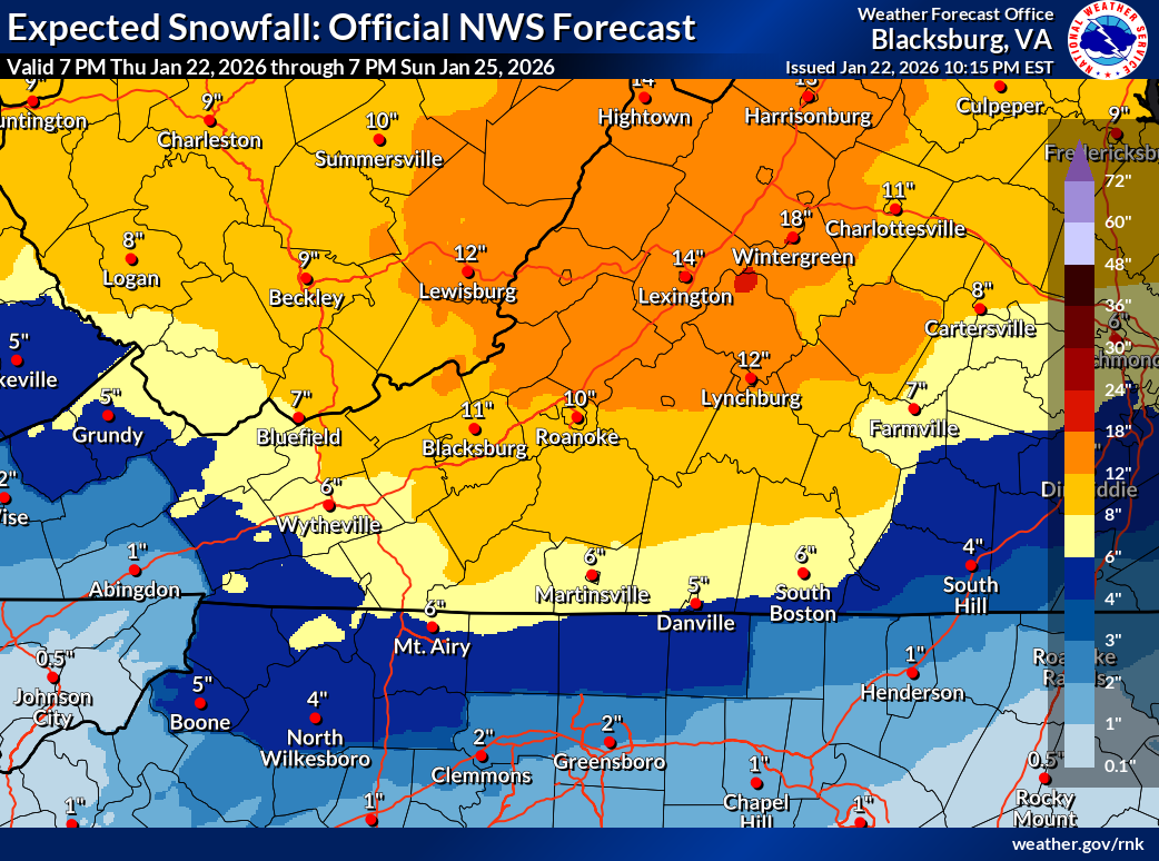
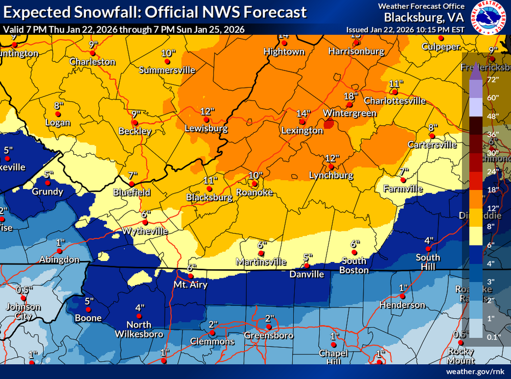
Paging @Disc... would love to know why yall are bullish about snow amounts especially south of 460?
-

Possible Record Breaking Cold + Snow Sunday 1/25 - Tuesday 1/27
SACRUS replied to TriPol's topic in New York City Metro
Updated -
ICON has not recovered it's best look for Monday coastal development from 24 hours ago (0z Jan 22). Trough tilt was too progressive this run
-
And here come the cliff divers ...