All Activity
- Past hour
-
.thumb.jpg.ad3a2e31d30aff035044689b311a0540.jpg)
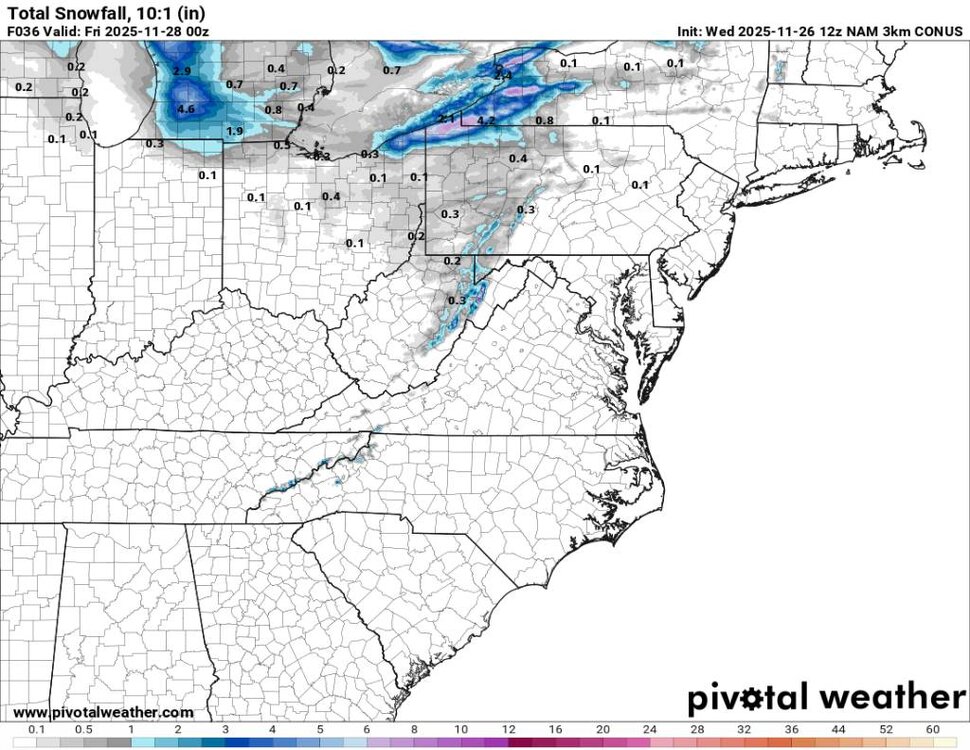
Nov 28-30th Post Turkey Day Wintry Potential
nvck replied to Chicago Storm's topic in Lakes/Ohio Valley
If snow really makes it to Cincinnati on Saturday .... I'd be shocked to say the least lol -
I must have missed where somebody did that?
-
It’s a light hit of snow before mostly ZR, but nice to have it in the ballpark of a better outcome.
-
When i made mention of that season yesterday, Your pictures were what came to mind but i didn't remember who it was, That was downright depressing.
-

E PA/NJ/DE Autumn 2025 Obs/Discussion
simbasad2 replied to PhiEaglesfan712's topic in Philadelphia Region
The ICON starts the 12z suite off with a pretty heavy ice storm for areas slightly NW of I-95 -

Central PA Fall Discussions and Obs
MAG5035 replied to ChescoWx's topic in Upstate New York/Pennsylvania
OK, I’m in. That pattern next week has evolved into something much more favorable on modelling the last few days since my last post. Gone is dumping the trough in the west and building southeast ridging. Instead, we’re bringing the energy for what is now Sunday’s system out quicker. While that low still cuts, the faster timing and fairly weak low invites a potential light snowfall/mix event in at least interior C-PA with some cold air still in place. So that’s actually the first thing I’m looking at with this period. That system resets the boundary, and we have a nice placement of the PV over Hudson Bay to help push down any semblance of SE ridging and we’re set for this Tues-Wed system that is looking way more wintry than it did several days ago. GFS is obviously a big and widespread snowstorm for a lot of folks. The Euro and Euro Ensemble are in fact showing this system as well. 0z Euro had the widespread precip but a more confined snow area, 6z Euro was shaping to look pretty decent but ran out of hours. Euro GPT doesn’t have it at all and those ensembles are weakly hinting at the system. Key will be a balance of amping this system up enough and placing/strength of the high to the north to set up cold and a more widespread snow swath. The feature itself looks progressive (no closed 500mb low or neg tilted trough) but low originates in the Gulf, so moisture source is there. -

2025-2026 Fall/Winter Mountain Thread
Maggie Valley Steve replied to Buckethead's topic in Southeastern States
Some people love to trash the GFS. It picked up this possibility a week ago. I've learned in my 50+ years of closely monitoring the weather that you use all the tools in the toolbox when analyzing patterns and possibilities... -

December 2025 regional war/obs/disco thread
WinterWolf replied to Torch Tiger's topic in New England
Yup, I think I snapped a picture of it…got absolutely nothing out of it..what a flop. -
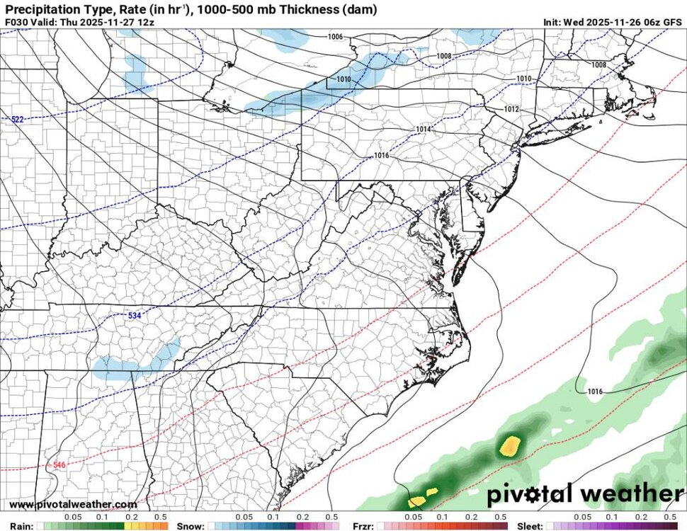
Icon at 120. Big slug of moisture primed in the gulf!!

-
You just beat me! I saw the same thing. Decent cold too. https://www.tropicaltidbits.com/analysis/models/?model=icon®ion=us&pkg=mslp_pcpn_frzn&runtime=2025112612&fh=120
-

December 2025 regional war/obs/disco thread
Sey-Mour Snow replied to Torch Tiger's topic in New England
Ya feet of digital snow is usually modeled a few times a week it seems in January and February. But if it were to ever actually happen, December would be so much better. -
Just lost power because of 45-50 mph gusts. We were supposed to host Thanksgiving. Hopefully the power comes back on by morning.
-
Icon might hop on board here .
-
3K NAM picking up on this moisture as well. Nothing major but will feel like winter. Sent from my SM-G998U using Tapatalk
-
Just amazing. You took Wills photographic memory and digitized it. lol Really appreciate your effort this is gold!!!
-

E PA/NJ/DE Autumn 2025 Obs/Discussion
Duca892 replied to PhiEaglesfan712's topic in Philadelphia Region
Mike Masco favoring folks in Ohio... waiting for 12z GFS... we are so back -

2025-2026 ENSO
40/70 Benchmark replied to 40/70 Benchmark's topic in Weather Forecasting and Discussion
Sure, it can be argued that perhaps that PV will recover more slowly than some are implying, but I think interpreting that subtle weakening around Xmas as a major disruption is what is insane...especially on the heels of this current head-fake. December reversals are exceedingly rare, which is why reflection events are so common place in January and February. -
Rain Totals (11/25) New Brnswck: 0.76 NYC: 0.74 EWR: 0.72 LGA: 0.58 JFk: 0.58
-
Could see some flakes tomorrow for Thanksgiving. Going to be freaking cold too just in time for Thanksgiving. Sent from my SM-G998U using Tapatalk
.thumb.jpg.91fed4eeac72f2f53a28cce7c13aa2c7.jpg)
.thumb.jpg.d0732583843dbfff90ac6ed0bd1065f4.jpg)
-
Was it the euro last winter that did the same in Feb? Toss all those far and wide.
-
Acting like a forecast for 2+ weeks into the future is a foregone conclusion is insane. Think its fair to post a forecast that might show things trending differently than they are being shown now.
-

Central PA Fall Discussions and Obs
Jns2183 replied to ChescoWx's topic in Upstate New York/Pennsylvania
Trust the vibe! We are due for a December to Remember Sent from my SM-G970U1 using Tapatalk -

December 2025 regional war/obs/disco thread
Ginx snewx replied to Torch Tiger's topic in New England
Impressive Lenticular in Gorham NH yesterday. Stole from FB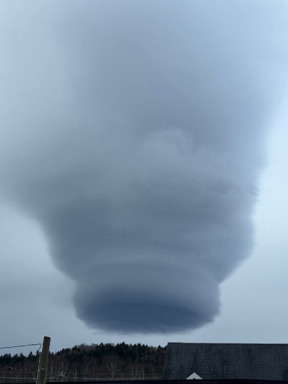
-
A step in the right direction. Models are far from seeing the pattern out into December.
-
Was looking at that. Temps are going to crash as well.


.jpg.450bd542b9324d89971c945b21697213.jpg)
.jpg.9194b49ba95e90f12bdfea38786301b8.jpg)


