All Activity
- Past hour
-
I get the sense that some of our younger and newer posters feel like the more they post, that they will literally "will" the storm closer. Friendly annual reminder that your post count means nothing. We have established "regulars" here with post counts well under what you'd think. Sure, many of us are in the thousands. Take it from somebody who grew up on Eastern and then here....you will not gain any favor with people by beating the same horse over and over and over and over again - and posting 3 word posts all day and night. It clutters the thread. It will either snow or it won't, It's okay to be excited...but you don't have to reply to EVERY post. And not EVERY post needs to be morphed into an inside joke. Sit back and learn a little. Enjoy the hunt. It's okay to read a bit more than you post. THINK about whether you REALLY need to be post every time you go to hit the reply button. In all likelihood (and I mean this in a lovingly/mentoring way) your post will, in the realm of things, be barely a speck in terms of significance.
-
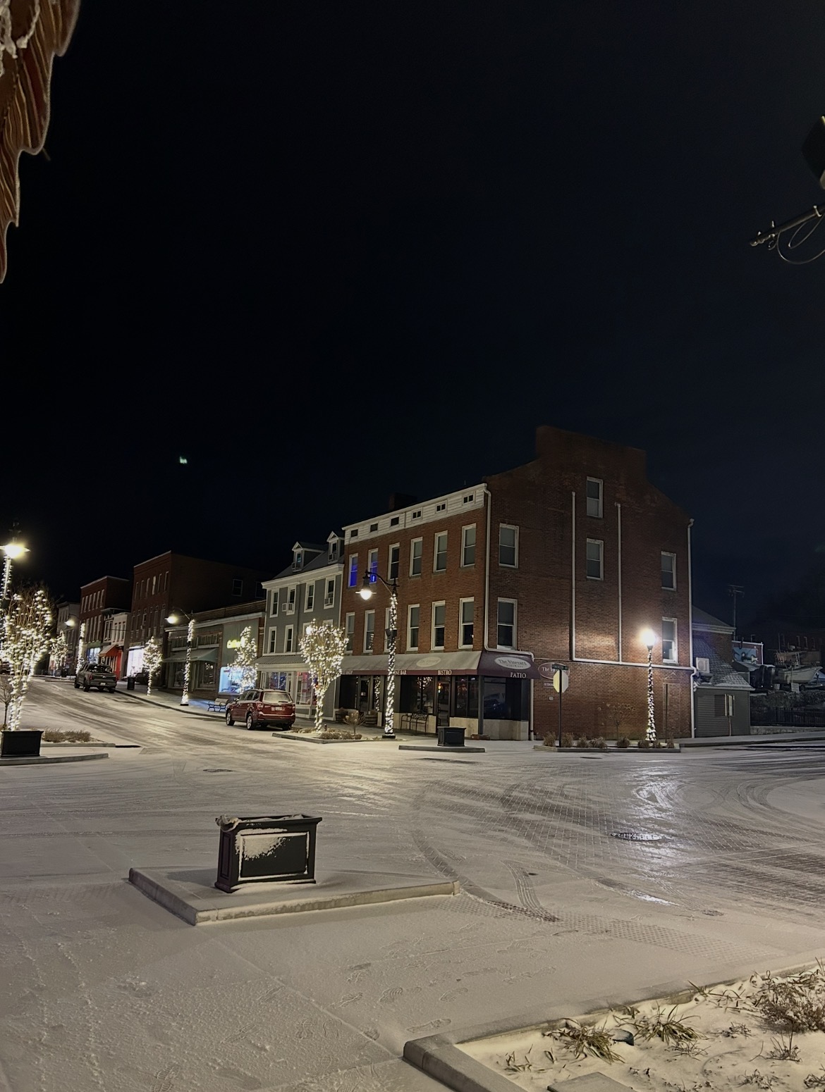
Back edge past here. Just a few flurries remaining. Sure looks nice out there. After no wind all day, was near dead calm since daybreak the wind has picked up some and snow has started blowing off the rooftops. Total for the day 2.8”. Yesterday 3.4” Two day total 6.2”. Total depth currently is exactly 6”. Real nice multi day event!
-
Number 23 and we will call it a season.
-

Rise of the Machines: January 18-19 Winter Storm Obs Thread
Go Kart Mozart replied to WxWatcher007's topic in New England
This evening underachieved a bit down here, but tomorrow I will wake up and it will look like real winter outside! -
I know this is for Philly, but this just underscores the upside potential for this general area in the next 7 days.
-
Havre de Grace got a solid half inch+. Downtown’s total is probably around 6.0” for the season.

-
Probably squeezed out an inch from today. City Metro was too warm, too wet and the storm got going too late
-

January 18th Back Door NW Trend Snow OBS Thread
Hurricane Agnes replied to Mikeymac5306's topic in Philadelphia Region
Holy crap. Just went out to measure (had cleared the board a few hours ago just as it started, and got another 2.5" on top of the earlier 1.25", making it 3.75" for the day and 5.25" over the 2 days. Once that temp got below 32, the stuff started piling up. That officially took me over the foot mark for snow this season so far. Currently partly cloudy (with stars visible) and 27 with dp 26. -

Storm potential January 17th-18th
WestBabylonWeather replied to WeatherGeek2025's topic in New York City Metro
We’re going to bust low here. Maybe end with an inch. Is what it is. The next few weeks look interesting. -
Not that it matters since it’ll be different at 00z, but I don’t think the euro was coming any farther N than it was at the end of its run. My guess is a light-mod snow event if it played out post 144. There was a shortwave sitting over the lakes that was about shunt everything E. We’ll see how the N stream eventually orients itself. Here is 18z euro vs the Ai to better illustrate… .
-
Snowing hard here. Sticking pretty good.
-

Storm potential January 17th-18th
Winterweatherlover replied to WeatherGeek2025's topic in New York City Metro
If they do, they do but I'd rather the nickel and dimes then waiting on the KU event that never comes. -
Storm potential January 17th-18th
Winterweatherlover replied to WeatherGeek2025's topic in New York City Metro
Really nice outside, Nothing heavy but more powdery then i expected given surface around freezing, I guess that's due to the cold 850s? -
-
.thumb.png.4150b06c63a21f61052e47a612bf1818.png)
Rise of the Machines: January 18-19 Winter Storm Obs Thread
HIPPYVALLEY replied to WxWatcher007's topic in New England
Hopefully, you beat that tonight. -

Storm potential January 17th-18th
SnoSki14 replied to WeatherGeek2025's topic in New York City Metro
Biggies are coming -

Rise of the Machines: January 18-19 Winter Storm Obs Thread
The 4 Seasons replied to WxWatcher007's topic in New England
2 left today, make em count -
You're probably not wrong lol.
-
Storm potential January 17th-18th
WestBabylonWeather replied to WeatherGeek2025's topic in New York City Metro
End of the month. -
So when we say Mid Atlantic in this forum does this include NJ/PA? And is general consensus that this does not get squashed?
-

Rise of the Machines: January 18-19 Winter Storm Obs Thread
Damage In Tolland replied to WxWatcher007's topic in New England
I dunno where you live but someone in that general area is getting 8-10 -

Rise of the Machines: January 18-19 Winter Storm Obs Thread
moneypitmike replied to WxWatcher007's topic in New England
Finally 32.0 -

Storm potential January 17th-18th
donsutherland1 replied to WeatherGeek2025's topic in New York City Metro
This evening. A steady light-to-moderate snow: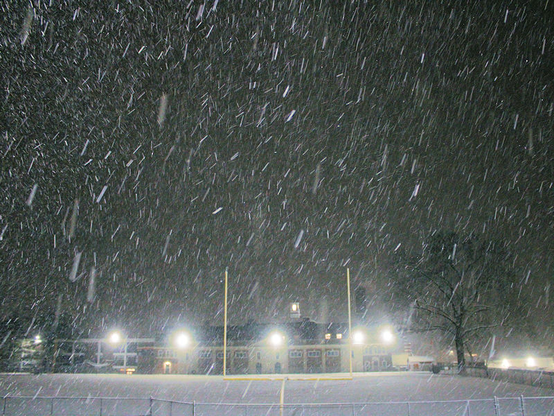
-

Rise of the Machines: January 18-19 Winter Storm Obs Thread
George001 replied to WxWatcher007's topic in New England
I’m not getting anywhere near 8 -
Get out. How dare you rain on Brick Tamland’s parade.