All Activity
- Past hour
-
Wonder if we sneakily hit our max heat index today. I'd trade in the 70+ dps to make a run at a all-timer on Friday though.
-
 Lease agreements require new home owners to accept the original terms of the lease. I wouldn't agree to that, either. one of the big reasons why you want to own the panels and not lease them
 -
Highest HI here was 106. Temp now 93 after a high of 95
-
They might've hit 100° today if they weren't river winded for so long.
-

2026-2027 Super El Nino
snowman19 replied to Stormchaserchuck1's topic in Weather Forecasting and Discussion
No coincidence that we saw the twin/triplet tropical cyclones back in April with this super El Niño. A whole parade of them are expected to form this month, keeping the WWBs/westerlies going in their wake as far as the eye can see…. -
91 dew 75. Temps is hot but not extreme. Been steady at about 91 since just after 12pm. Humidity is what tough. Heat index staying in the low 100s. Sometimes days like this will have a late day high in the evening. South wind fizzles and a quick spike occurs.
-
84 is the record right? Same is NYC. I think that year EWR had a low of 86 one of those nights lol. NYC had a 104/84 - I remember, lost the keys to my place out on a date. It was like in the mid 90s in the city at 2am as I was trying to get back into my building lol.
-
96/76 for the 4pm ob at DCA, HI of 110. Damn.
-
Yeah the chance that we'll see anything here today is very slim -- I'd say a 10% chance. But I am watching radar and praying, lol.
-
 Just dropped under 90F. Seeing some PWS on the harbor in Kittery now in the upper 70s.
 -
Any threat to low max records? That stretch from July 22-24, 2011 at DCA was nuts with 83 84 84
-
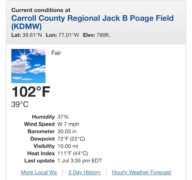
The airport being 102° by itself would be suspect, but there's a fairly well sighted APRS/COOP site south of there sitting at 99°. That area of Westminster has become very built up over the past decade so it's possible?
-

2026-2027 Super El Nino
forkyfork replied to Stormchaserchuck1's topic in Weather Forecasting and Discussion
what does this have to do with el nino? -
99 here. Feels terrible with the dewpoint at 73.
-
Seems to me that the big puffy white clouds are growing and becoming more ominous. Are T-storms in our forecast for today?
-
98/75/112 at home in south Alexandria. Pool time
-
Carroll county airport cookin
-
The white line is for Heat Advisory Threshold (100F) and Pink for Extreme Heat Warning threshold (110). That's why the colors.
-
 I'm fascinated by heat synoptics as meteorologically trackable phenomenon. And also now more than ever, a recognized phenotype that comes with sensible weather-related hardships and actual risks ...etc. I don't like actually being in it. I think that's fair. People are fascinating with shit. Curiosity. There are those interested in nuclear physics ... why should that mean they should enjoy wondering sightless through the smoldering aftermath of a nuclear holocaust? I think it's a bit of a petty overreach to criticize ourselves for being fascinated with deep historic cold and blizzards, tornadoes and hurricanes... big heat waves, super volcanoes and cosmic ray bursts. Now, if someone is wanton of destruction and seeing other's in harms way then suffering losses ..etc, that's something else. Perhaps a weird sociopathy
 -
When doing the research for my system, I came across these stories over and over. the way I mitigated this risk was to hire the same contractor to install the system AND replace/upgrade the roof. that way if there were any leaks, I knew who would be responsible. it was a few more bucks than contracting these out separately This is why you want to own the system. No "permission" required to remove them or work on the system.
-
The big trees here are dead. There are a bunch in my back woods that are probably near nut producing age. Some have minor beech leaf disease…some not much at all.
-
 May have snuck in a 95 here if there was no solar contamination with the nearby station. BAF was 95 last hour which gives it a little more credibility.
 -
ORD and MDW both peaked at 94° yesterday.
-

E PA/NJ/DE Summer 2026 Obs/Discussion
WxUnit replied to PhiEaglesfan712's topic in Philadelphia Region
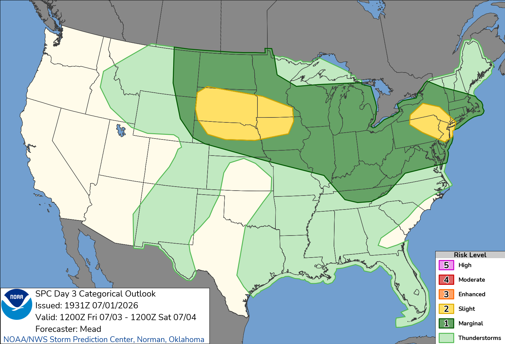
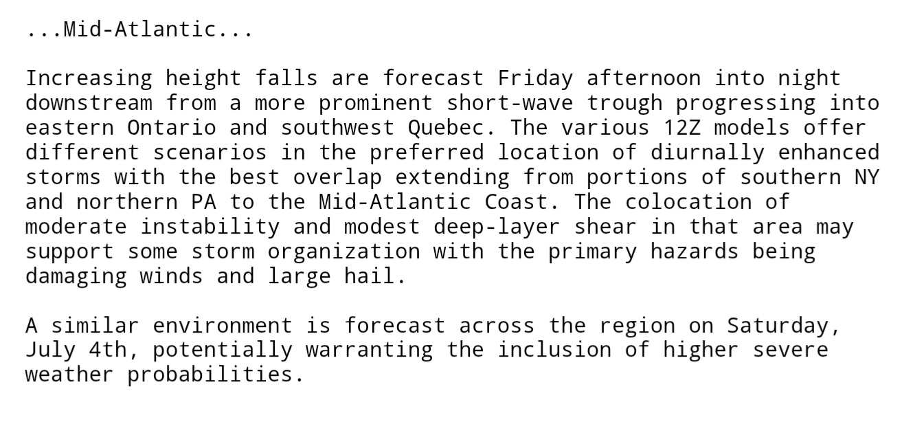
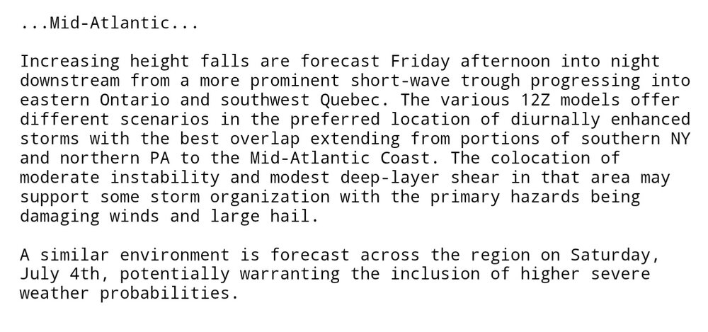
Need to monitor both Friday and Saturday for severe weather. As of right now Saturday looks to have the best potential.
-
ORD and MDW both peaked at 94° yesterday. ...2026 90°+ Day Tally... 5 - ARR 3 - ORD 3 - MDW 3 - RFD 3 - PWK 3 - UGN 3 - LOT 2 - DPA