All Activity
- Past hour
-
Yeah I saw that… the AI has been flagging that period for a few runs. Not necessarily cold but something interesting.
-
It is going to take a LOT to overcome the Pacific influences. The other thing too is it looks like the brunt of strongest influences from what may transpire with the PV will be more over Europe than our side of the Globe
-
Dont you people ever get tired of the endless rains? October 2024 was perfect any socalled wild fires aren't a problem here outside of August 1995. This isn't California. And this weather is exactly what we need. Yes temporarily. There can be a lot of southern branch moisture but it doesn't mean it will come north. It didn't in 1965-66 and it didn't in 2001-02 I envision it hitting the Carolinas and Virginia not up here thankfully. LOSE WEIGHT Dont be so sure that will happen and if it does it will be a small blip and this pattern will return in a modified form by later December into January.
-
I texted my daughter this and she only responded “lol yeah I saw”
-
If we had some blocking or maybe Bering Sea ridging then it’s possible we could see impacts, but we will be fighting the Pacific influence.
-
Really all this strat PV hoopla because of some 10mb charts I mean come on lol
-
Some see super Nino and just automatically fixate on that one aspect.
-
Lol https://www.espn.com/college-football/story/_/id/50301954/maryland-offers-shot-free-tuition-staying-4th-vs-illinois
-
December is going to surprise even the most seasoned prognosticator. More and more evidence showing up.
-
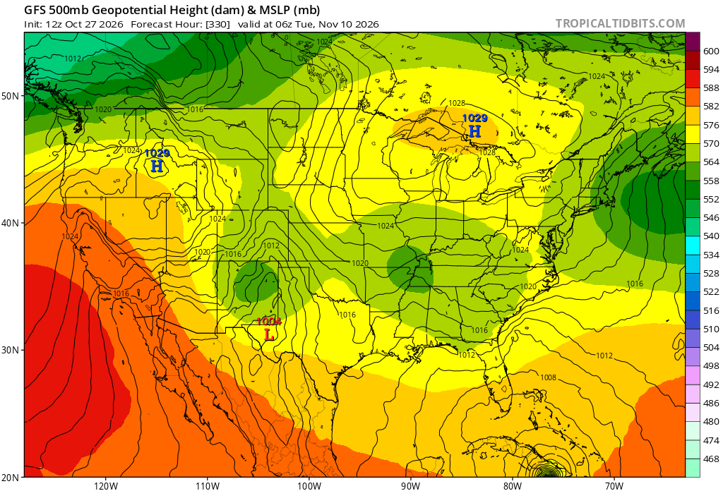
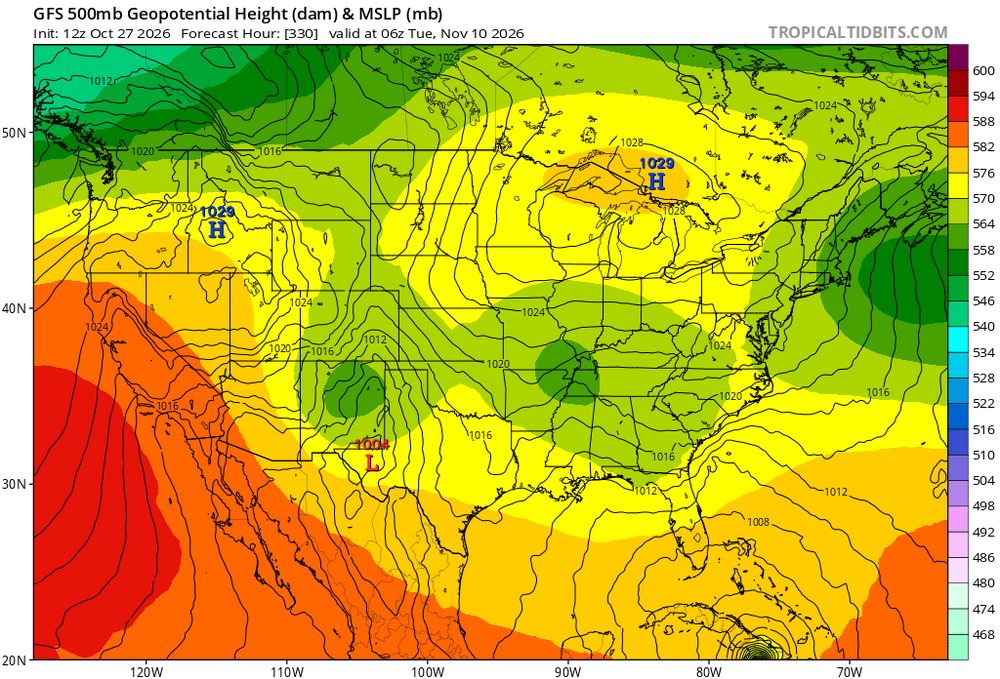
So many cutoffs from the fantasy GFS with a bubble over the N GLs. Then a 960mb hurricane hitting E Cuba and moving NE to E of the Bahamas lol. Fantasy range hasn't been this fun in a long time
-
Yup...looking like we may see things get a bit active...could be some good news for some of the ski areas within the West too. Noticed too systems will be flying across the country
-
congrats everyone
-
Yeah, poor air quality was notable today compared to the past 9 days of blue cloudless skies.
-
 legitimate indian pharmacy online: ZenithIndusRx - indian pharmacy prednisone
-
Banger of a weather run we're on. I look forward to a week of drizzle in the near future.
-
I will say the pattern on the EPS and AI EPS is a little interesting regarding storminess later in the 11-15 day.
-
December looks warm on that, but that seems to be the call from many.
-
Pittsburgh Area Fall 2026
RitualOfTheTrout replied to Ahoff's topic in Upstate New York/Pennsylvania
Just commenting in a vacuum without what implications this pattern may have for Winter weather later, this has been an amazing stretch. I've been thoroughly enjoying the comfortable days and cool crisp evenings and nights, and overall dry days. Looks great for remaining football game / senior night and all the Halloween events. Also barely a need to run the furnace, house warms up enough in the evening and stays comfy until the next day. -

Yellow Medicine County, MN - Climate Fact or Climate Fiction?
Brewbeer replied to Cobalt's topic in Climate Change
the science is sound, they don't need to "like" accept OR disprove anything else is delay, deny, distract; it's tiring -
E PA/NJ/DE Autumn 2026 Obs/Discussion
MGorse replied to PhiEaglesfan712's topic in Philadelphia Region
El Nino continues to strengthen. The latest from the Climate Prediction Center: https://www.cpc.ncep.noaa.gov/products/analysis_monitoring/enso_advisory/ensodisc.shtml -
Strat stuff often muddies the forecasting water because there is no straightforward effect on the troposphere. Sometimes it helps, sometimes it doesn't mean jack squat lol. And I've never seen anyone consistently forecast how a SSW event affects sensible wx. We know what it "can" do but we also know not to read too deeply into it until you can see the effect on the longwave pattern in the troposphere. That said, this is an unusually strong event very early in the season. I wouldn't be surprised if this event kick starts a long duration -AO late Nov into Dec. Seasonal models have been honking a -AO in jan/Feb for months. It's hard not to like what we're seeing right now. We don't need siberian air to get snowstorms. Normal continental cold with a suppressed storm track is often enough in DJF.
- Today
-
Tomorrow will be another fair day. Highs will top out in the lower 60s across much of the region. Afterward, temperatures will warm into the middle and upper 60s for the remainder of the work week. Much of the region could approach or reach 70° on Friday. Unseasonable warmth will continue into the start of November. Dry conditions will likely persist through next week. The ENSO Region 1+2 anomaly was +5.2°C and the Region 3.4 anomaly was +3.4°C for the week centered around October 14. For the past six weeks, the ENSO Region 1+2 anomaly has averaged +5.08°C and the ENSO Region 3.4 anomaly has averaged +3.22°C. ENSO Region 3.4 breaks the all-time record most recently set in the prior week. The ongoing strong El Niño, will continue to strengthen through the mid-fall. The SOI was +12.57 today. The preliminary Arctic Oscillation (AO) was +1.303 today. Based on sensitivity analysis applied to the latest guidance, there is an implied near 99% probability that New York City will have a warmer than normal October (1991-2020 normal). October will likely finish with a mean temperature near 59.4° (1.5° above normal). Supplemental Information: The projected mean would be 2.5° above the 1981-2010 normal monthly value.
-

Yellow Medicine County, MN - Climate Fact or Climate Fiction?
Cobalt replied to Cobalt's topic in Climate Change
It appears that Yellow Medicine County, MN (Population 11,404) is poised for a top 10 warm October. -
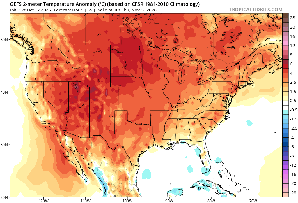
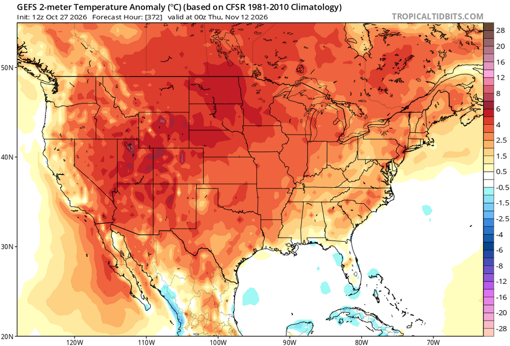
GEFS look cool heading into mid-November.
-

2026-2027 Record-breaking El Nino
GaWx replied to Stormchaserchuck1's topic in Weather Forecasting and Discussion
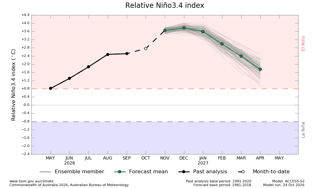
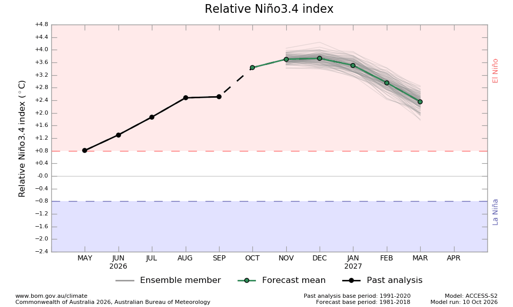
The BoM has been overshooting every near month forecast by a significant margin (0.4+) since April with it averaging 0.5 too high! Oct is joining the club: Here was the forecast for Oct as of just 2 weeks ago, which had Oct way up at +3.5: Look how far down the Oct 24th MTD is: only +2.8! So, full Oct is likely going to end up at no warmer than +3.0, which would make its Oct forecast verify 0.5+ too warm and thus continue the trend that started with April: This tells me that Nov will have a good chance to end up verifying ~0.5 too warm or at ~+3.2 vs its forecast of +3.7. Either Nov or Dec will very likely end up as the peak. So, if BoM monthlies were to peak at, say, +3.3, then the NOAA monthlies would likely come in cooler and peak at ~+3.0 and the trimonthlies would likely peak at ~+2.8, which is where I am currently (not much change from before).