All Activity
- Past hour
-
Just based on feel, being out and about in Manhattan there was no was it was a run of the mil around 90 degree day. It had to be mid to upper 90s out. The Park was especially lagging yday considering we haven't had alot of heavy rain lately. It doesnt make sense that even the heliport downtown was running ahead of the Park and their sensor is sitting on a pier sticking out into the East River, just about to open into Upper NY Bay.
-
-
Got down to 74 for the low before started warming up. Sun already baking!
-

2026-2027 Super El Nino
csnavywx replied to Stormchaserchuck1's topic in Weather Forecasting and Discussion
It's possible. I'm kind of leaning that way this time since we're likely to get a fully coupled and canonical ('97-like) full warm pool discharge and it will take some time for that to recover. -

Junorch obs and discussion 2026
Damage In Tolland replied to Damage In Tolland's topic in New England
Let’s tear as much down as possible! -
Thursday could be an interesting day in these parts.
-
Yeah, the tree growth over the equipment since the 90s when the trees are leafed out from the spring into late fall has been creating an artificial high temperature cooling there. I can remember when the station was out in the open and often had warmer highs than LGA and sometimes Newark. More record highs today around the area. RECORD EVENT REPORT NATIONAL WEATHER SERVICE NEW YORK, NY 252 AM EDT SAT JUN 13 2026 ...RECORD DAILY HIGH TEMPERATURE SET AT LAGUARDIA NY... THE HIGH TEMPERATURE REACHED 98 DEGREES FRIDAY, JUNE 12 AT LAGUARDIA AIRPORT. THIS BREAKS THE OLD RECORD OF 96 DEGREES, SET IN 2017. RECORDS FOR THE LAGUARDIA NY AREA GO BACK TO 1939. RECORD EVENT REPORT NATIONAL WEATHER SERVICE NEW YORK, NY 252 AM EDT SAT JUN 13 2026 ...RECORD DAILY HIGH TEMPERATURE, HIGH MINIMUM TEMPERATURE SET AT ISLIP NY... THE HIGH TEMPERATURE REACHED 94 DEGREES FRIDAY, JUNE 12 AT ISLIP MACARTHUR AIRPORT. THIS BREAKS THE OLD RECORD OF 91 DEGREES, SET IN 2017. THE LOW TEMPERATURE WAS ONLY 72 DEGREES FRIDAY, JUNE 12 AT ISLIP MACARTHUR AIRPORT. THIS BREAKS THE OLD RECORD HIGH MINIMUM OF 70 DEGREES, SET IN 1973. RECORDS FOR THE ISLIP NY AREA GO BACK TO 1963. RECORD EVENT REPORT NATIONAL WEATHER SERVICE MOUNT HOLLY NJ 530 PM EDT FRI JUN 12 2026 ...RECORD HIGH TEMPERATURE BROKEN IN PHILADELPHIA PA... A HIGH TEMPERATURE OF 98 DEGREES WAS RECORDED AT THE PHILADELPHIA INTERNATIONAL AIRPORT IN PHILADELPHIA PA TODAY. THIS BREAKS THE OLD RECORD HIGH FOR TODAY OF 95 DEGREES PREVIOUSLY SET IN 1947 AND 2015. RECORDS FOR THE PHILADELPHIA PA AREA DATE BACK TO 1872. RECORD EVENT REPORT NATIONAL WEATHER SERVICE NEW YORK, NY 438 PM EDT FRI JUN 12 2026 ...RECORD DAILY HIGH TEMPERATURE SET AT KENNEDY NY... THE HIGH TEMPERATURE REACHED 95 DEGREES TODAY AT JOHN F. KENNEDY INTERNATIONAL AIRPORT. THIS BREAKS THE OLD RECORD OF 92 DEGREES, SET IN 2017. RECORDS FOR THE KENNEDY NY AREA GO BACK TO 1948. RECORD HIGH TEMPERATURE BROKEN AT ATLANTIC CITY AIRPORT NJ... A HIGH TEMPERATURE OF 96 DEGREES WAS RECORDED AT THE ATLANTIC CITY INTERNATIONAL AIRPORT NEAR ATLANTIC CITY NJ TODAY. THIS BREAKS THE OLD RECORD HIGH FOR TODAY OF 94 DEGREES PREVIOUSLY SET IN 2017. RECORDS FOR THE ATLANTIC CITY AIRPORT NJ AREA DATE BACK TO 1943. RECORD EVENT REPORT NATIONAL WEATHER SERVICE MOUNT HOLLY NJ 528 PM EDT FRI JUN 12 2026 ...RECORD HIGH TEMPERATURE TIED IN TRENTON NJ... A HIGH TEMPERATURE OF 94 DEGREES WAS RECORDED AT THE TRENTON-MERCER AIRPORT NEAR TRENTON NJ TODAY. THIS TIES THE RECORD HIGH FOR TODAY PREVIOUSLY SET IN 1933. Data for June 12, 2026 through June 12, 2026 Click column heading to sort ascending, click again to sort descending. NY LAGUARDIA AIRPORT WBAN 98 NJ TETERBORO AIRPORT COOP 97 NJ HARRISON COOP 97 NJ NEWARK LIBERTY INTL AP WBAN 96 NJ TETERBORO AIRPORT WBAN 95 CT NORWICH PUBLIC UTILITY PLANT COOP 95 NY ISLIP-LI MACARTHUR AP WBAN 94 NY SHRUB OAK COOP 93 NY CENTERPORT COOP 93 NY FARMINGDALE REPUBLIC AP WBAN 93 NY PORT JERVIS COOP 93 NJ CALDWELL ESSEX COUNTY AP WBAN 93 NY SHIRLEY BROOKHAVEN AIRPORT WBAN 93 NY BAITING HOLLOW COOP 93 NJ CHARLOTTEBURG RESERVOIR COOP 92 CT MERIDEN MARKHAM MUNICIPAL AP WBAN 92 NY SYOSSET COOP 92 NY ST. JAMES COOP 92 NY UPTON COOP - NWSFO NEW YORK COOP 92 CT IGOR I SIKORSKY MEMORIAL AIRPORT WBAN 91 NY WESTCHESTER CO AP WBAN 91 CT GUILFORD COOP 91 NY RIVERHEAD RESEARCH FARM COOP 91 NY MONTGOMERY ORANGE COUNTY AP WBAN 90 NY NY CITY CENTRAL PARK WBAN 90 NY ORIENT POINT STATE PARK COOP 90 Data for June 11, 2026 through June 11, 2026 Click column heading to sort ascending, click again to sort descending. NJ NEWARK LIBERTY INTL AP WBAN 97 NJ TETERBORO AIRPORT WBAN 97 NY LAGUARDIA AIRPORT WBAN 96 NY JFK INTERNATIONAL AIRPORT WBAN 95 NJ CALDWELL ESSEX COUNTY AP WBAN 94 NY PORT AUTH DOWNTN MANHATTAN WALL ST HEL ICAO 93 NY MONTGOMERY ORANGE COUNTY AP WBAN 93 NY FARMINGDALE REPUBLIC AP WBAN 93 CT MERIDEN MARKHAM MUNICIPAL AP WBAN 93 NY WESTCHESTER CO AP WBAN 92 NY ISLIP-LI MACARTHUR AP WBAN 92 NY RIVERHEAD RESEARCH FARM COOP 92 NY SHIRLEY BROOKHAVEN AIRPORT WBAN 92 NY NY CITY CENTRAL PARK WBAN 91
-

Central PA Summer 2026 Discussion/Obs Thread
pawatch replied to Voyager's topic in Upstate New York/Pennsylvania
57 degrees for the low this morning. Blue bird sky. -
The Hamden F4 is my earliest memory. We’re due!
- Today
-
Closest Cocorahs station to my location showing on 2.15” of rain since May 1st. Arid.
-
Lol 71/61 here.
-
Think that was the best I’ve ever seen any usmnt play
-
62.0/56 Refreshing morning.
-

Central PA Summer 2026 Discussion/Obs Thread
mahantango#1 replied to Voyager's topic in Upstate New York/Pennsylvania
US National Weather Service State College PA Favorites · · 530 AM Saturday June 13th, 2026: Enjoy today with lots of sun and lower humidity than in recent days. There is potential for more strong to severe storms on Sunday, mainly during the afternoon into the evening. The main threat will be strong winds and heavy downpours. -
Central PA Summer 2026 Discussion/Obs Thread
mahantango#1 replied to Voyager's topic in Upstate New York/Pennsylvania
-
One more from Friday sunset

-
Photos from sunset Friday in Columbia


-
Central PA Summer 2026 Discussion/Obs Thread
mahantango#1 replied to Voyager's topic in Upstate New York/Pennsylvania
.CLIMATE... The high temperature on Friday at Harrisburg reached 94 degrees. This broke the old record of 92 degrees, last set in 2017. -
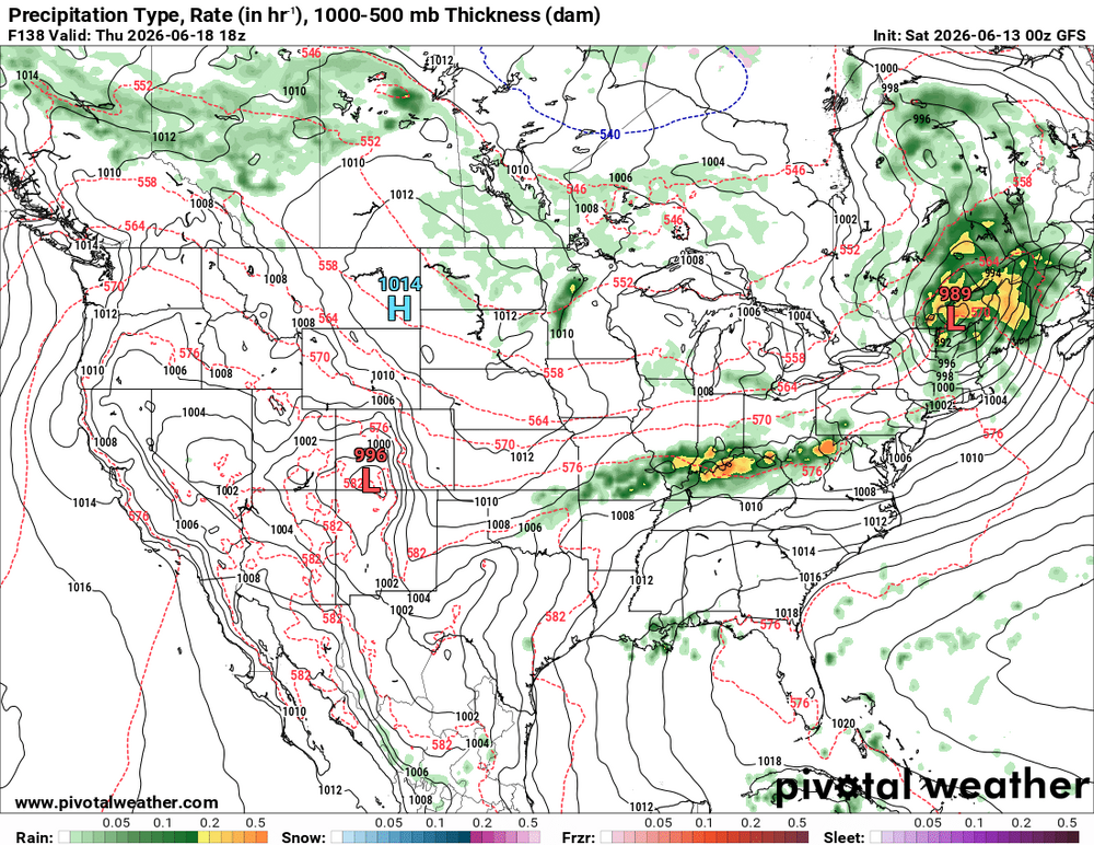
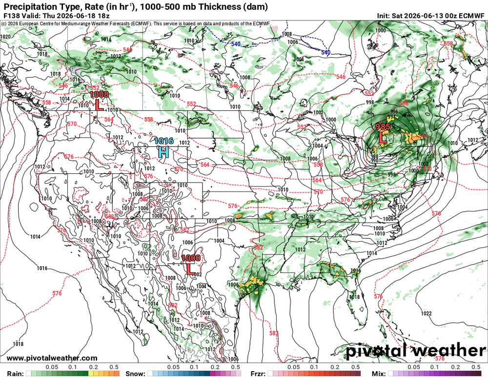
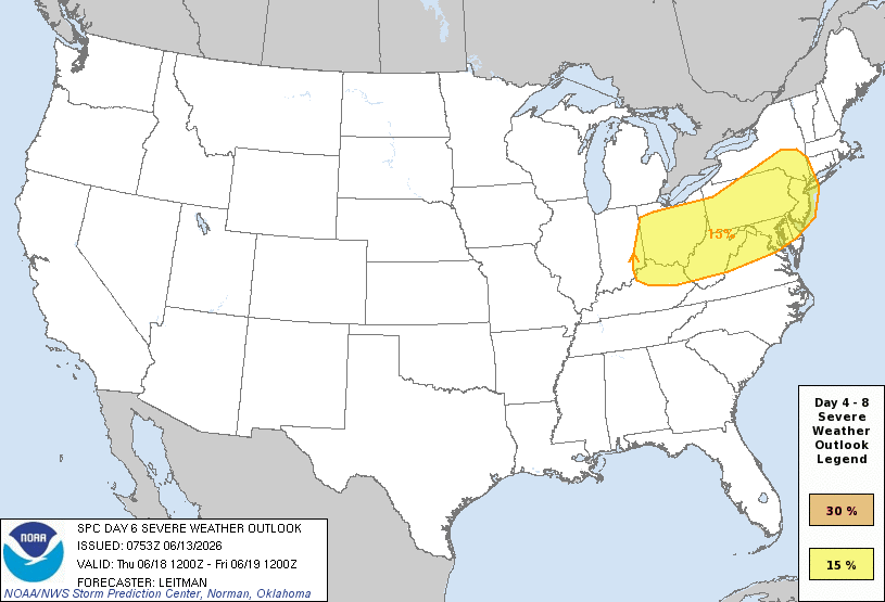
SPC DY6 has SVR outlooked OH Valley-DCA-NYC? Time for WxWiz to starting getting ready. He been waiting for something like this for so long! And CoastalWx can stop saying "SNE SUCKS for convection!" LOL. From pattern recognition, I am very impressed, and it takes a *lot* to impress me for svr these days. An unusually strong sfc low for mid June is fcst (below 990 mb) to track across southern Ontario and Quebec. 00z GFS and ECMWF same idea on 6/18 for wind fields -- GFS a bit stronger than the ECMWF, but does not matter, they are still through the roof for this time of year. GFS 120 kt 250, 95 kt 500, 75 kt 700, 65 kt 850 and 925 in New England this time of year w/ available CAPE this time of year? Ho-ly ( )!!! Actually, w/ these kind of wind fields, you don't need more than say 2000-2500 CAPE for sigtor. Anywhere from the OH Valley-Mid Atlantic-Northeast may be in for a sig tor event! I don't have to quote the big tor outbreak for our region, but just mention July 10, 1989, and WxWiz will faint! FYI, winds of 65 kt at 850 existed for the ORH 1953 event. For the July 10. 1989 event, the sfc low that tracked across NNE was "only" 998 mb. Not overstating things here for potential at all. But of course, it's all in the details. *But* again, SPC outlooking SVR this part of the country on DY6 this time of year? That says something! You don't get that w/o a synoptically-evident set up.
-
The DY6 SPC outlook? It is definitely warranted. An unusually strong sfc low for mid June is fcst (below 990 mb) to track across southern Ontario and Quebec. Wind fields are clearly high end for this time of year. GFS and ECMWF same idea on 6/18 -- 70 kt 500, 60 kt 700, 50 kt 850, 40 kt 925 over Mid-Atlantic. That means business and this time of year w/ higher CAPE? Anywhere from the OH Valley-Mid Atlantic-Northeast may be in for a sig tor event June 23, 1944 comes to mind so does June 8-9. 1953. Also July 10, 1989 (New England's largest single day tornado outbreak for number of tornadoes). Derecho not out of the question. Svr mode is up in the air at this range. Not overstating things here for potential at all. But of course, it's all in the details. *But* SPC outlooking SVR this part of the country on DY6 this time of year? That says something! You don't get that w/o a synoptically-evident set up!


- 651 replies
-
- 4
-

-

-
- severe
- thunderstorms
- (and 7 more)
-
This ^.
-
I'll be on atlantic city tuesday through Friday.. maybe ill get lucky..
-
This has the feeling of being one of our "runs" of severe risk. Been a while. When this happens it can last a week or two anecdotally
- 651 replies
-
- 2
-
-

-
- severe
- thunderstorms
- (and 7 more)
-
Morning AFD from LWX for Sunday DISCUSSION... KEY MESSAGE 1...Dry conditions today, severe thunderstorms return Sunday. Quiescent wx returns today with mostly sunny skies and lower humidity. Temps will still be 5-8 degrees above average for highs (upper 80s to around 90), but it will feel cooler and less humid as dewpoints drop into upper 50s and low 60s. Sun features the next chance for severe wx. SPC has maintained a Level 2 out of 5 (Slight Risk) for the area, however they have increased the wind probs to 30%. Could see upgrade to Level 3 out of 5 (Enhanced Risk) depending on model trends over the next 24 hours. Stay tuned for the latest... In terms of the meteorology, a sw will rotate around the base of an UL trof Sun. Ahead of the wave, southerly flow will usher in anomalous moisture with PWs nearing 2" and dewpoints near 70F. The sw will bring height falls aloft near peak heating resulting in notable instability. The above will overlap with increasing wind shear. The combination of increasing instability, shear, and large scale forcing for ascent ahead of the shortwave and an approaching cold front will lead to the development of widespread thunderstorms during the afternoon, some of which could be severe. Model soundings indicate steep low level lapse rates (especially for the Mid-Atlantic) which will result in higher DCAPE values and therefore stronger wind gusts. There`s still a fair amount of spread in guidance with respect to the timing and exact placement of the storms, but as of now the threat looks to be greatest to the east of the Blue Ridge. Some guidance has discrete supercells ahead of the front, followed by linear segments which make sense given unidirectional shear. The main threats with storms will damaging winds, large hail, locally heavy rainfall, and frequent lightning. WPC has a Level 1 out of 5 (Marginal ERO) for the metros, but progressive nature and prevailing drought look to limit the overall flood threat. The system`s cold front will move through Sunday night, advecting cooler and drier air into the region, which will bring the threat for severe thunderstorms to an end.
- 651 replies
-
- 1
-
-
- severe
- thunderstorms
- (and 7 more)
-
Oh okay then SPC... @high risk @Kmlwx @wxmeddler @Eskimo Joe Day 4-8 Convective Outlook NWS Storm Prediction Center Norman OK 0253 AM CDT Sat Jun 13 2026 Valid 161200Z - 211200Z ...DISCUSSION... ...Days 5-6/Wed-Thu -- Lower MO/Mid-MS Valley to Ohio Valley and Mid-Atlantic... An upper trough is forecast to deepen over the Upper Midwest/Great Lakes on Wednesday. As this occurs, an intensifying 500 mb jet streak will develop across the central Plains and increase to 80-100 kt as it moves into the Mid-MS Valley Wednesday night, and spreads eastward across the Ohio Valley and Northeast on Thursday. At the surface, low pressure will develop over the northern/central Plains late Tuesday night into early Wednesday. As this occurs, increasing southerly low-level flow will quickly transport rich Gulf moisture northward into the Lower MO/Mid-MS Valley by Wednesday afternoon as the surface low moves across IA and a trailing cold front moves eastward in tandem with the low across portions of the central Plains and Mid-MS Valley. Strong to extreme instability is forecast across the strongly sheared warm sector. An all-hazards severe thunderstorm event appears likely. An intense southwesterly low-level jet is expected to develop during the evening. This could support upscale growth into an MCS moving across portions of the Midwest Wednesday night, posing a risk for swaths of damaging winds. This system will spread east on Thursday across parts of the Ohio Valley into the Mid-Atlantic/Northeast. A continued risk for all severe hazards, and possible MCS with damaging winds, will persist as the mid/upper jet streak is forecast to remain quite strong as it overspreads a seasonally moist airmass. While some timing differences of aforementioned features is evident in various NWP guidance, overall medium range consensus and mean calibrated ML/AI guidance suggests a multi-day severe episode is likely as this system overspreads portions of the Midwest to the Mid-Atlantic/Northeast, though the 15 percent risk areas may shift in the coming days as details become better resolved, and higher probabilities are possible in subsequent outlooks. The southern extent of severe potential is more uncertain across parts of the Plains toward the TN Valley as these areas will remain further removed from stronger flow aloft. ..Leitman.. 06/13/2026
- 651 replies
-
- 2
-
-
- severe
- thunderstorms
- (and 7 more)