All Activity
- Past hour
-
might see a blizzard on the 4th of July
-
1 more time Gfs also tries to spin up a coastal


-
The coverage is low due to the best forcing lagging farther west (where overnight crapvection muddied things), but I feel like high end potential deserves a watch. Especially in southern Michigan where the population isn’t exactly sparse. The parameters were certainly there for a strong tornado, even if the models weren’t firing convection at that time.
-
One last chance during this timeframe and thats it.

-
April
-
Gfs is getting colder in the mid range like the Euro.
-
Today was a fluke, but it goes to show why the new SPC format is flawed trash. The science is currently not good enough and never will be good enough to set a min/max on hail size, wind speed and tor strength in outlooks and MD's.
-
Reminds me of the 2011 Tuscaloosa–Birmingham tornado or the El Reno tornado in 2013 that everyone hates talking about. Hopefully the injured recover, but my god... I hate those multi-vortex tornadoes that have those "arms." Those are some of the most violent tornadoes out there.
-

Central PA Spring 2026 Discussion/Obs Thread
Blizzard of 93 replied to Voyager's topic in Upstate New York/Pennsylvania
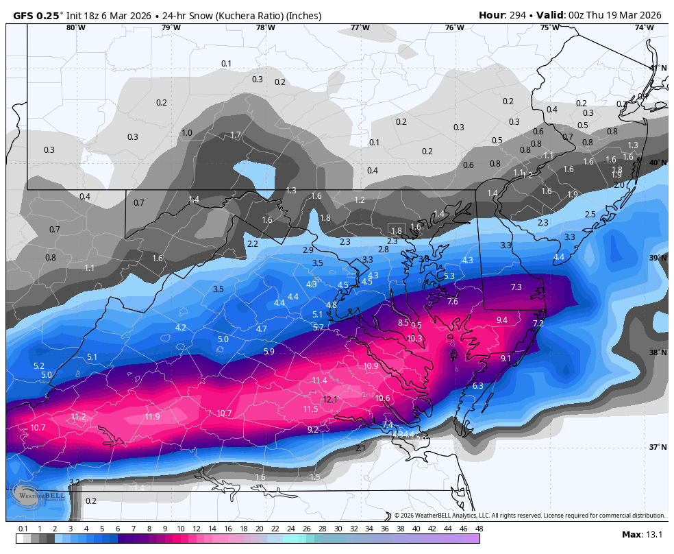
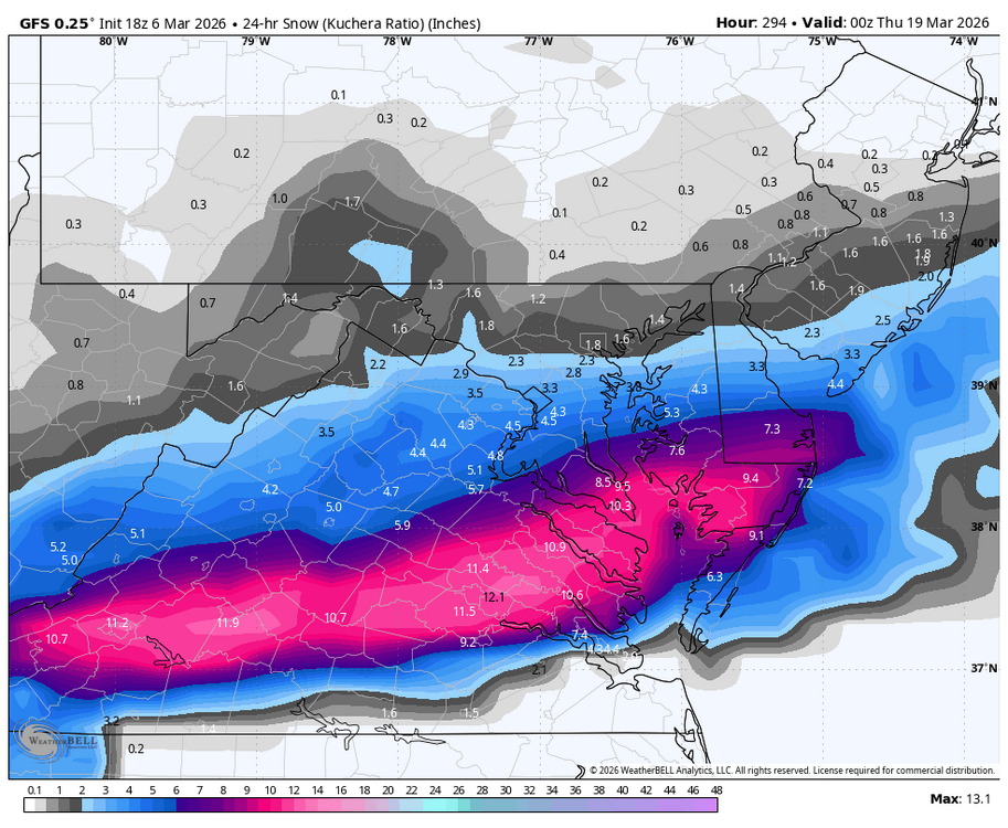
I’m looking forward to our 3 or 4 day warm up while actively tracking snow chances around St.Patty’s Day! I am hunting that 6.2 of snow to get MDT to climo seasonal average! -
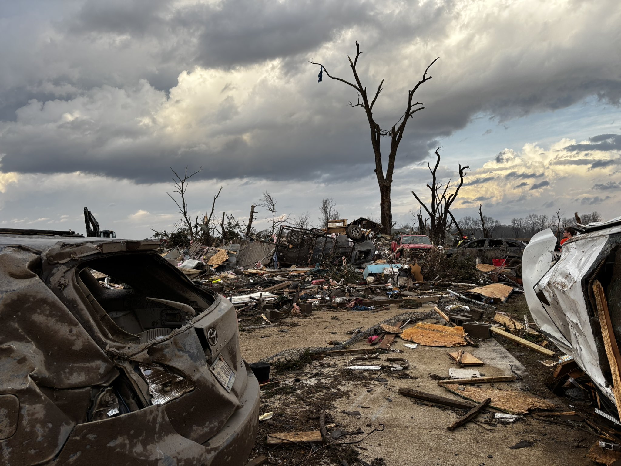
Could be the first MI violent tornado in nearly 50 years. Tragic to say the least .
-
Make it stop
-
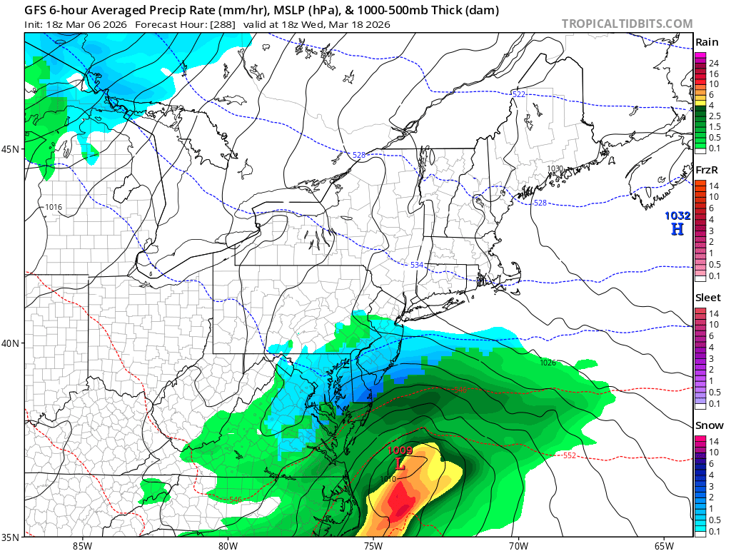
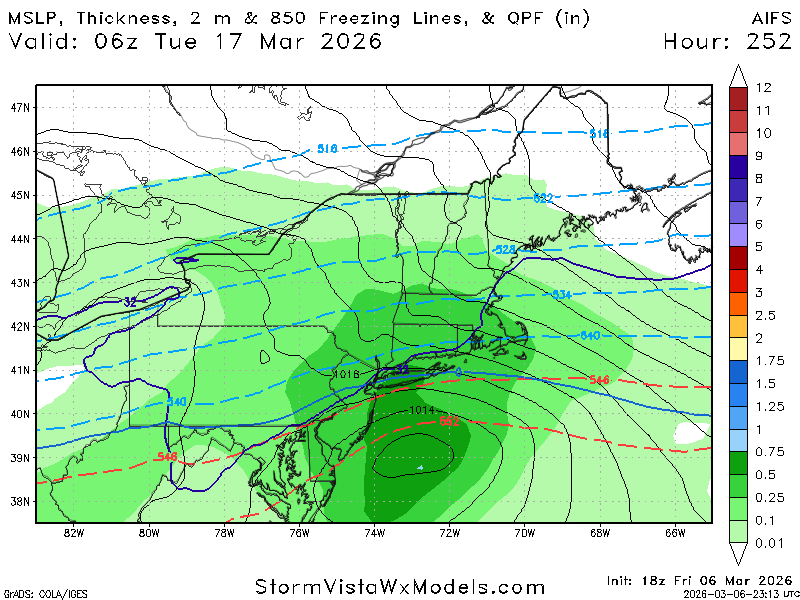
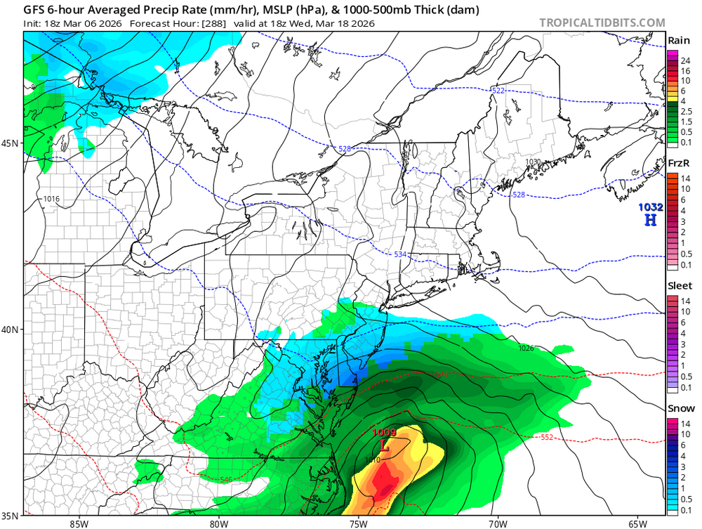
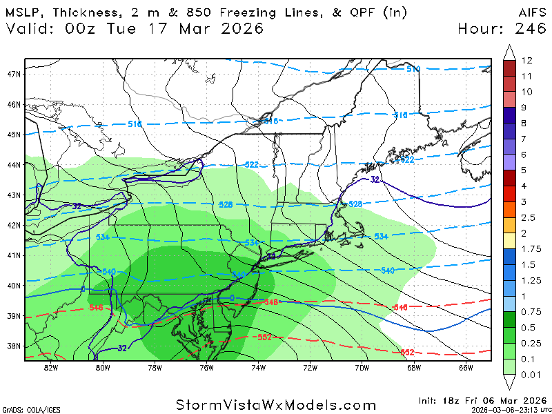
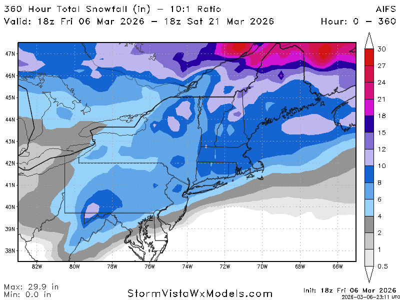
WB 18Z GFS does have fantasy storm during mid March period.
-
Yep. It all goes down the drain eventually. A lot will be gone mid week
-
Been a steady melt off here. Kind of been under the radar, but we’ve lost a lot of snow. Guessing a lot of what’s left gets vaporized next week here. Couple days of 60+ will make a big dent
-
Tough to measure this with the wind but I'm thinking 6" and maybe 7-8" considering the early melting.
-
^that's violent, to say the least.
-
First winter with DJF all below 60˚ (although barely, the pre-xmas Gricn hit 59˚ in BOS) since 2013-2014. After Feb 2015 (high of 39˚) every Feb was above 60˚ until last year (53˚) and this year (49˚). I'll take it.
-

Texas 2026 Discussion/Observations
radarman replied to Stx_Thunder's topic in Central/Western States
could be a cap bust in N TX, at least til later -
Had some decent rain come through around 4. Picked up .12”. Only the 6th of the month and have 3.81” of rain. More than I think I had all last summer.
-

2026 Severe Wx - General Thread
HillsdaleMIWeather replied to largetornado's topic in Lakes/Ohio Valley
Multiple fatalities in Union City
-

Central PA Spring 2026 Discussion/Obs Thread
Voyager replied to Voyager's topic in Upstate New York/Pennsylvania
From mid 60's to mid 50's to low 50's to now upper 40's... I am beyond pissed off right now. The warmth is delayed and almost denied, but the cold push will be right on schedule. Saturday A chance of showers before 7am. Areas of fog before 10am. Otherwise, mostly cloudy, with a high near 48. Calm wind becoming south around 5 mph. Chance of precipitation is 30%. -
By far the worst week of weather I remember in a very long time.
-
Finished with a nice 1.10" from this morning. Nice soaker. May get a little more later tonight but looks like the 2nd round will die off mostly before reaching the QCA.
-

2025-2026 ENSO
michsnowfreak replied to 40/70 Benchmark's topic in Weather Forecasting and Discussion
Yes. If anything, I've seen time and time again this winter modeled warmups or cold breaking down get muted once it gets closer in time from Michigan eastward. The warm west/cold east pattern has dominated since November, so will be interesting to see if its more of the same in late March. Regarding the cold shots, euro and gem continue to be much colder then the gfs. -
2026 Severe Wx - General Thread
HillsdaleMIWeather replied to largetornado's topic in Lakes/Ohio Valley
Not one to crap on the spc but kinda baffled they didn't issue a watch. They've shown multiple times they're willing to issue one for lone supercells causing tornadoes but this time just didn't.