Cartier God
-
Posts
55 -
Joined
-
Last visited
About Cartier God

Recent Profile Visitors
2,931 profile views


.thumb.jpg.ad3a2e31d30aff035044689b311a0540.jpg)
-
Could be the first MI violent tornado in nearly 50 years. Tragic to say the least .
-
Was about to drop 400 bones on an ice shanty. Might shelf that one for a bit .
-
-
the trend is our friend here in wayne county

-
Thanks man, still can’t believe it happened. Chase of a lifetime for me.
-
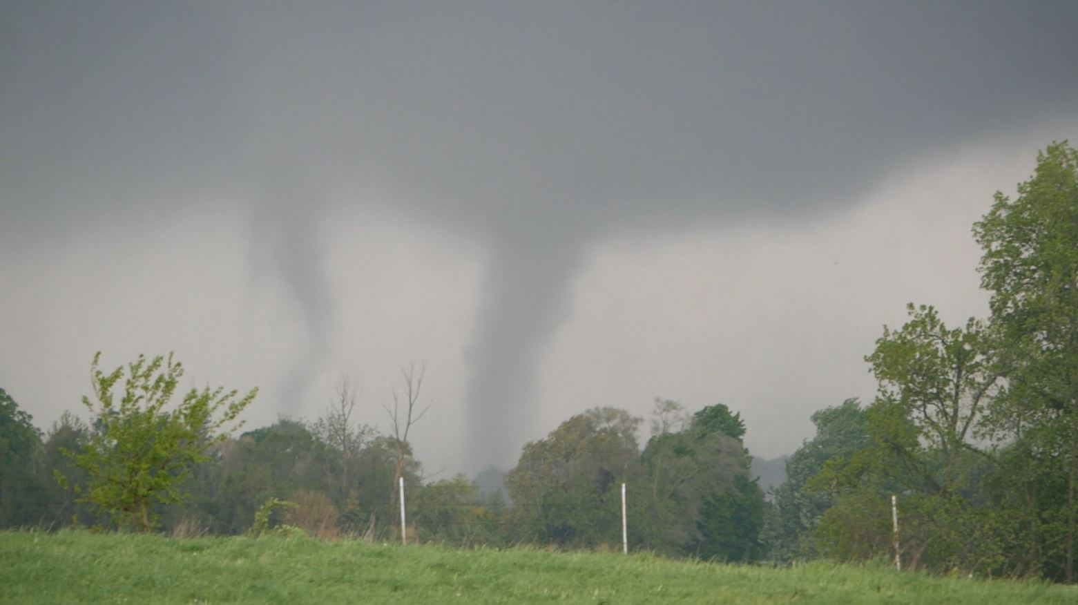
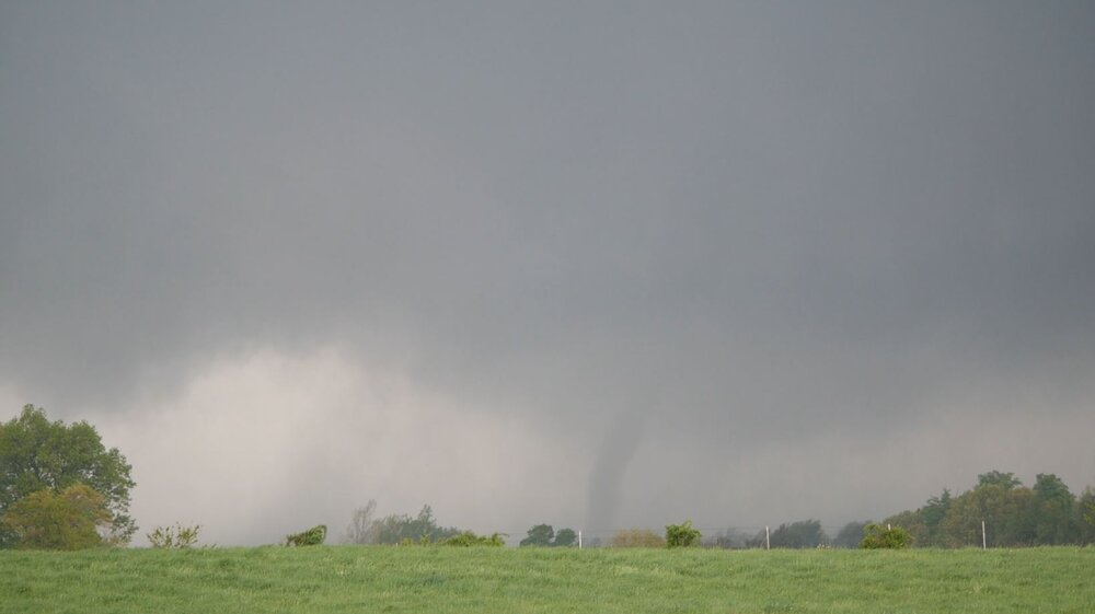
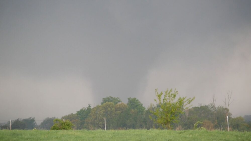
Some more pictures of the Colon/Sherwood tornado, all taken from M-66. Officially rated a 130mph EF2. Path length 19.52 miles and 950yds wide. .
-
Intercepted a significant tornado 2 miles ENE of Nottawa, MI just after 5:45pm yesterday. Me and my friend Rune watched as it crossed M-66 in front of us. Multiple vortices were visible prior to the tornado crossing the highway. Afterwards it fully condensed and intensified before becoming shrouded from our vantage point by rain and trees. This tornado made the one I saw in Perry last year seem like a bird fart. We saw large debris from barns lofted, but thankfully no fatalities were reported. Fighting for a view through the trees was difficult (customary for chasing in MI), but we managed to get some decent shots. This tornado has been preliminarily rated EF2 with winds upwards of 130mph, with another damage survey taking place tomorrow.

- 153 replies
-
- 12
-

-
Saw my second tornado today, multi vortex near Nottawa. I’ll post more pics tomorrow .
- 153 replies
-
- 15
-
-

-
First chase of the year locally today, saw a tornado warned supercell while stopped northeast of Eaton Rapids. .
-

2023 Short/Medium Range Severe Weather Discussion
Cartier God replied to Chicago Storm's topic in Lakes/Ohio Valley
Yesterday’s chase started after leaving a party at my boss’s house around 6:30. Storms began to fire southwest of the warm front around 6:40, looking pretty anemic at first. Still on the fence about chasing, I drove to Staples in Frandor to stop and check mesoanalysis. Soon after I noticed a small cell east of Dewitt that was broadly rotating on radar. I drove north to get a view of the storm at 7:10. Shortly after I caught a glimpse of the distant updraft base. As I approached the storm from the southwest, the RFD clear slot became more apparent, and a broadly rotating wall cloud could be seen. After heading east to get a better view, I witnessed the old updraft base move off to the north and begin to occlude. Off to the south, a new and more vigorous updraft was wrapping up. I cautiously drove east behind the storm. After the trees parted, I was greeted with a closer view of the mesocyclone looking ENE on Bath Rd. The RFD surge was mesmerizing. A tornado looked imminent. I noticed wispy funnels emerging from the mesocyclone about 3 miles west of perry accompanied by rapid upward motion. I continued east as my view of the ground became obscured by trees. I stayed west of I-69 not wanting to risk getting too close or missing out on the storm structure. A weak tornado was visible at this point, lofting small debris. The funnel quickly widened and intensified after crossing I-69. I repositioned and gained sight of the tornado after stopping at the intersection of Bath and Ruess. I watched the now uncondensed funnel cross Ruess Rd, with a brief power power flash and some swirling debris noted. I continued east and witnessed a few more ragged lowerings before calling it a night and heading home at dusk. .- 882 replies
-
- 12
-
-
2023 Short/Medium Range Severe Weather Discussion
Cartier God replied to Chicago Storm's topic in Lakes/Ohio Valley
Was on this storm for nearly an hour and a half last night, watching it change from a weakly rotating updraft base to a large and damaging tornado as it entered Perry. Followed it from the west on Bath rd, witnessed lofted debris and power flashes as it crossed Ruess rd. Will post more pics after work -
The last tornado to be rated F4/EF4+ in Michigan was actually a little later, in April 1977. Two F4 tornadoes struck Kalamazoo and Eaton counties respectively. Still been an insanely long streak. I have to work up in Grayling today, otherwise I would fs be chasing today.
-
what's up with the 00z HRRR for tomorrow? really diminishes the severe threat for MI compared to 18z.
-
see April 3 1956. multiple supercells went surface-based and tornadic the instant they crossed the lake. not saying tomorrow will be anything like that, but it is possible this time of year.
-
March 24-25 Palm Killer (Snow Event)
Cartier God replied to hardypalmguy's topic in Lakes/Ohio Valley
ghost of kyiv reference