All Activity
- Past hour
-
WTF? Radar actually looked like a lock over Calvert last night when I turned out the lights, the precip was almost over us. Woke up this morning...nothing. This thread sucks.
-

Central PA Winter 25/26 Discussion and Obs
Blizzard of 93 replied to MAG5035's topic in Upstate New York/Pennsylvania
Bottom line is that Next weekend is still a period of interest that needs monitored for a possible Winter storm chance. -

2025-2026 ENSO
40/70 Benchmark replied to 40/70 Benchmark's topic in Weather Forecasting and Discussion
As someone who also has a great deal of experience making seasonal forecasts, I'm sure you understand that it can be tough to nail the timing and precise placement of the anomalies in a composite map. This was largely due to two factors: 1) The -NAO during the latter half of January was unexpected, and it caused the cold to focus east of where I had it. I touched on this in my write up. 2) I have not addressed this yet because I was saving it for the post season analysis, but I went more conservative than my forecast narrative would imply due to an overcompensation to account for CC. Two things were clear to anyone that took the time to actually read my work. I was expecting a very cold +TNH pattern to ensue after mid January, and I used 1951-2010 climo maps to forecast 1991-2020 anomalies. I testing some things out to try to better account for CC, but I think it's abundantly clear that I had a very firm grasp on the pattern this season. I'm not sure why you are so insecure despite possessing such a wealth of knowledge with regard to long range forecasting. I'm sure your failed business venture concerning gambling on the weather didn't help, buy my advice is to try to remain mindful of the perils of making others feel small as opposed to focusing more on how to make yourself feel tall. Better luck in your future endeavors- -
Central PA Winter 25/26 Discussion and Obs
Blizzard of 93 replied to MAG5035's topic in Upstate New York/Pennsylvania
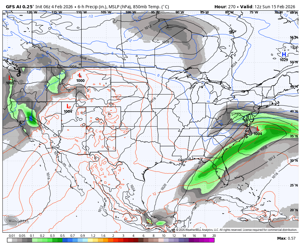
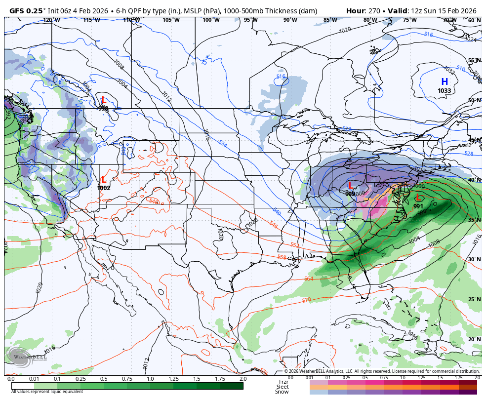
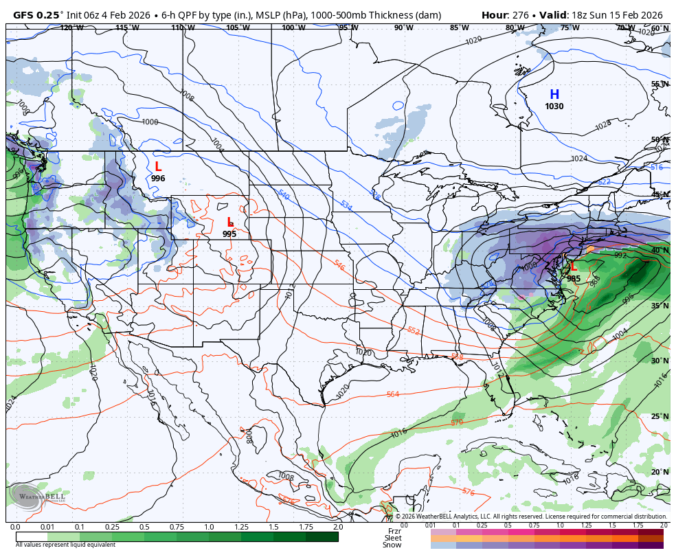
The 6z AI GFS actually keeps the low mostly to our south this run in response to the blocking.
-
This blows.
-

Winter 2025-26 Medium/Long Range Discussion
cyclone77 replied to michsnowfreak's topic in Lakes/Ohio Valley
Could make a run at 60 on Monday. -

February 2026 Medium/ Long Range Discussion: Buckle Up!
RevWarReenactor replied to Weather Will's topic in Mid Atlantic
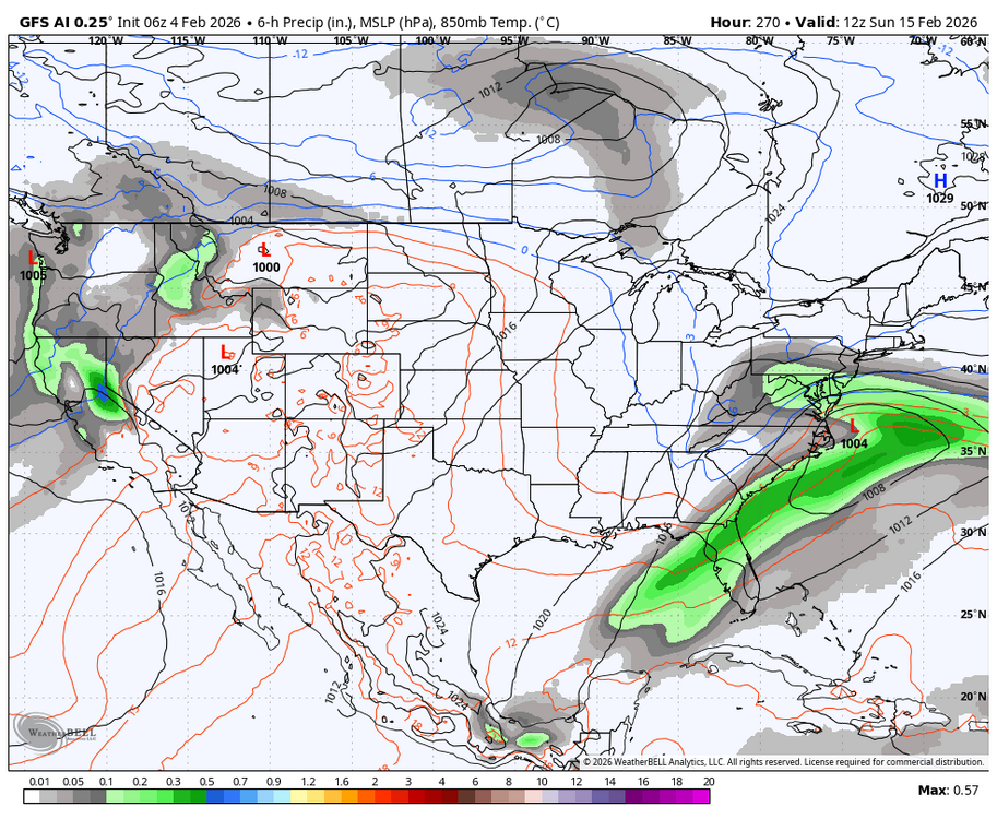
No model has a clue that far out. Honestly at this point the GFS shouldn't run past hr 84. You all are looking in the 200's. Its essentially fiction. -
Central PA Winter 25/26 Discussion and Obs
Blizzard of 93 replied to MAG5035's topic in Upstate New York/Pennsylvania
Likely way overdone to say the least this run, but the 6z GFS had the general idea of a low tracking towards Ohio & then forming a secondary in response to the blocking in the Northeast. The good recent off & on runs the last few days of the Euro & the AI models had this same general idea. The 6z GFS just gets the coastal going a little earlier & then rapidly strengthens it, producing a historic result, that is of course unlikely.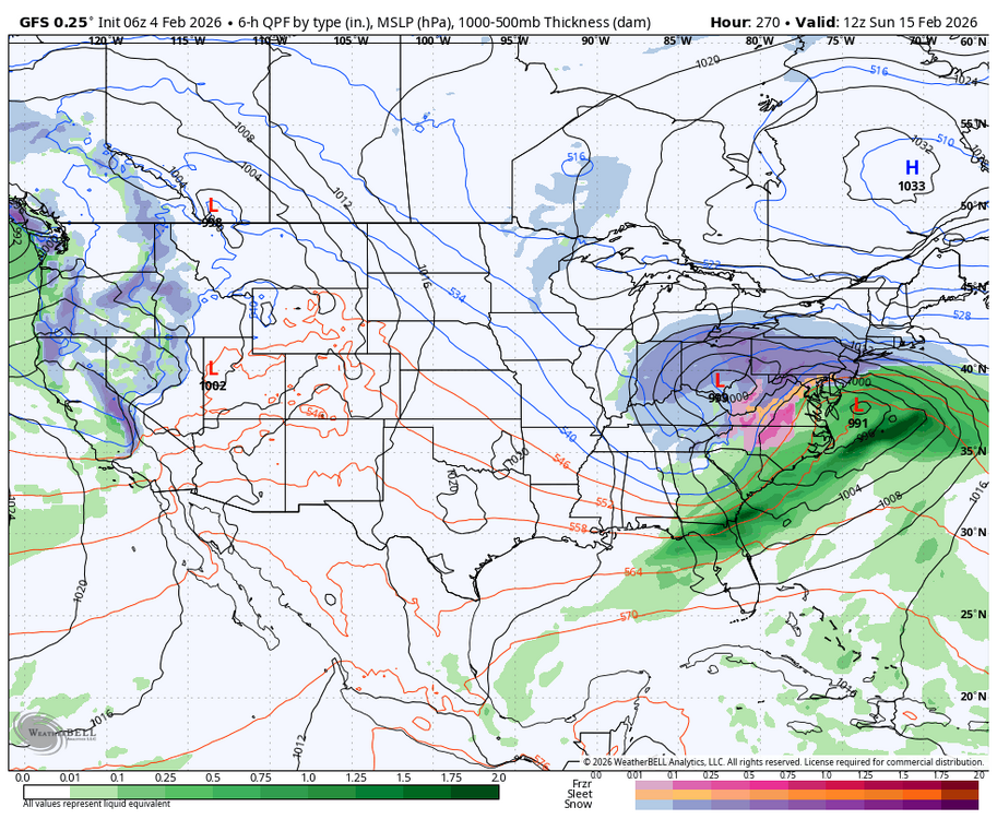

-

Friday February 6 FROPA / WINDEX small event
Kitz Craver replied to HoarfrostHubb's topic in New England
Is this thing gonna have any accumulation or just fropa snow showers? -

Central PA Winter 25/26 Discussion and Obs
MickeyTim6533 replied to MAG5035's topic in Upstate New York/Pennsylvania
euro AI is a dud -

Central PA Winter 25/26 Discussion and Obs
mahantango#1 replied to MAG5035's topic in Upstate New York/Pennsylvania
Let's do this! -
 Almost time to install!
 -

February 2026 Medium/ Long Range Discussion: Buckle Up!
stormy replied to Weather Will's topic in Mid Atlantic
Yes, "next weekend still has potential" though the father AI has lost interest. EPS, GEFS and GEPS are all interested.................. GFS Op will last about 4 more hrs.. -
I’d toss Brockton. They had 14.0” listed in new snow on 3/31 but nothing after that. On the April form they had no new snow listed and only reported depth. The depth for 4/1 was 18”. They had 0” going into the storm. So there’s data that doesn’t jive.
-
Central PA Winter 25/26 Discussion and Obs
paweather5 replied to MAG5035's topic in Upstate New York/Pennsylvania
Just need it to be right this one time. -
great old buildings, don't make 'em like this anymore
-

February 2026 Medium/ Long Range Discussion: Buckle Up!
Climate175 replied to Weather Will's topic in Mid Atlantic
It takes humility to say a lot don’t know how to read models properly (I’ll say myself included LOL), that’s why I try to read more than I post. Mainly post for reacting to developments. -
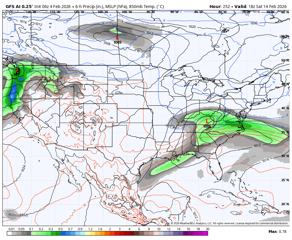
Ideally we squeeze in a clipper and a SWFE or coastal before the 15th. Then we’ll warm up and see what happens later. Some signs it tries to reshuffle a bit. If we can squeeze in something and limit the bleeding, that would be a better outcome than how it looked several days ago. It’s still kind of tenuous though and may not break our way.
-

Winter 2025-26 Medium/Long Range Discussion
A-L-E-K replied to michsnowfreak's topic in Lakes/Ohio Valley
these doldrum periods are the worst -
36.6 for the low, first non freezing low in forever. No rain here
-

February 2026 Medium/ Long Range Discussion: Buckle Up!
anotherman replied to Weather Will's topic in Mid Atlantic
If only the GFS had a single clue.... -
 Warm night at BDR. Spent most of the night at 28.
.thumb.png.922038f96c0575b1fc137f6fd97acbd5.png)
-
Central PA Winter 25/26 Discussion and Obs
MickeyTim6533 replied to MAG5035's topic in Upstate New York/Pennsylvania
Euro AI says what storm -
you must be new here, welcome to the forum!
-

February 2026 Medium/ Long Range Discussion: Buckle Up!
CAPE replied to Weather Will's topic in Mid Atlantic
Then Will says we should be using the ensembles more lol. Uh, yeah been saying and doing it forever lol. Only post I made this morning was 'big picture' ens mean. Good to see Will post that though. Reborn!


.png.0d039c1e5be217a58017f8863f000a4d.png)
