All Activity
- Past hour
-
that tree was ready to go. meh
-
off and on tropical downpours here all afternoon
-
There was a tornado in Shoemakersville, Berks County also.
-
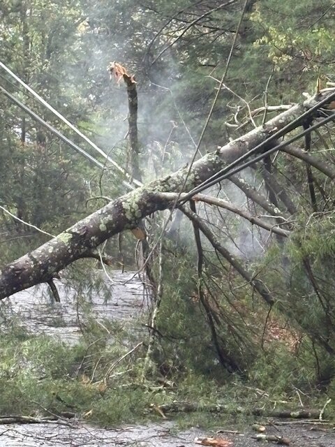
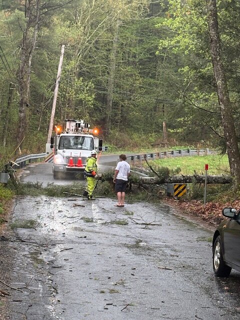
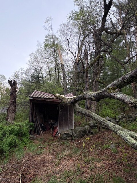
O.K. Damage-Devas-- The scene from Monson after Saturday's violent down-burst. The smoke in one of the pics is from a live wire--
-
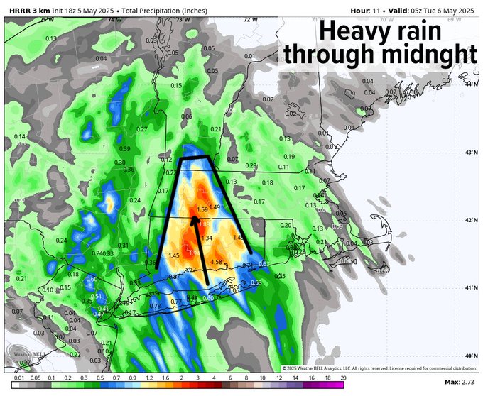
Hopefully this juices up more over the next few runs

-
Line of storms near RIC looks like a good track for Frederick!
-
Watch potentially coming soon Mesoscale Discussion 0701 NWS Storm Prediction Center Norman OK 0429 PM CDT Mon May 05 2025 Areas affected...Parts of the Mid-Atlantic Concerning...Severe potential...Watch possible Valid 052129Z - 052330Z Probability of Watch Issuance...60 percent SUMMARY...Thunderstorms moving north out of southeast Virginia will migrate into a buoyant air mass in place across the DelMarVa region. Re-intensification is expected and may result in an uptick in the severe hail/wind threat. Watch issuance is being considered to address this potential. DISCUSSION...A mix of semi-discrete thunderstorms and weakly organized linear segments continues to migrate north out of southeast VA. While a few stronger cores persist, much of the convection currently appears weak/disorganized based on GOES IR imagery and MRMS vertical ice/echo top data. However, these storms are moving into an environment characterized by better buoyancy (MLCAPE between 1000-2000 J/kg) that is in place across the DelMarVa region. Consequently, some uptick in intensity is anticipated within the next 1-2 hours. Deep-layer wind shear sampled by regional VWPs is fairly modest - around 20-25 knots of 0-6 km BWD. However, this should be sufficient for a few organized cells and linear segments capable of producing damaging winds and 1.0 to 1.5 inch hail. ..Moore/Smith.. 05/05/2025 ...Please see www.spc.noaa.gov for graphic product... ATTN...WFO...PHI...AKQ...CTP...LWX... LAT...LON 37687760 38617858 39057882 39307881 39677865 39997827 40077798 40057760 39837722 39257636 38867603 38407592 38117592 37777606 37557624 37357656 37357685 37467726 37687760 MOST PROBABLE PEAK TORNADO INTENSITY...UP TO 95 MPH MOST PROBABLE PEAK WIND GUST...55-70 MPH MOST PROBABLE PEAK HAIL SIZE...1.00-1.75 IN
- 468 replies
-
- 1
-

-
- severe
- thunderstorms
- (and 2 more)
-
Watch potentially coming soon
-

E PA/NJ/DE Spring 2025 Obs/Discussion
RedSky replied to PhiEaglesfan712's topic in Philadelphia Region
Steady rain shower -
Check out Upton snowfall map
-
Yeah, summer early and often this year. Going to be a lonnnng season
-
About damn time
-
Here in Eastern Sussex Co, we are the only bob left of severe drought in Tri-State area beside small blob in southern NJ. Total here since last Thur is .73. Very frustrating as we have missed heavier rains by 5-10 miles all year. Our wells need some drink before summer. You like boring weather, this is your place.
-
Tucker released https://www.espn.com/nfl/story/_/id/45011729/ravens-make-tough-decision-release-kicker-justin-tucker
-
JUST east of Manhattan today had good rains. That late morning batch really upped our totals
- Today
-
Friday. 09 Saturday. 78 Sunday. 78 Monday .87 Literally doubled my YTD totals..what a silly year
-
Lots of convection next few days . Deep summer hits and holds starting Sunday and beyond. Hammertime
-
Just .02" here so far. Maybe when this is done I'll get up to .10" lol
-
Yup. Nailed it Westetn NE
-
You missed your calling to be a forecaster. I got 0.21" on Saturday and 0.19" on Sunday lol I sh*t you not. The only interesting thing was 0.09" in way less than a minute yesterday - hardest I've seen it rain in a very long time.
-

-
I hope your basement floods with sewage lol. Seriously, though. I'm happy to see the western areas getting the moisture. That area out there has been worse than my area. I don't hate the radar down south. I'd love to get some thunderstorm action.
-
-
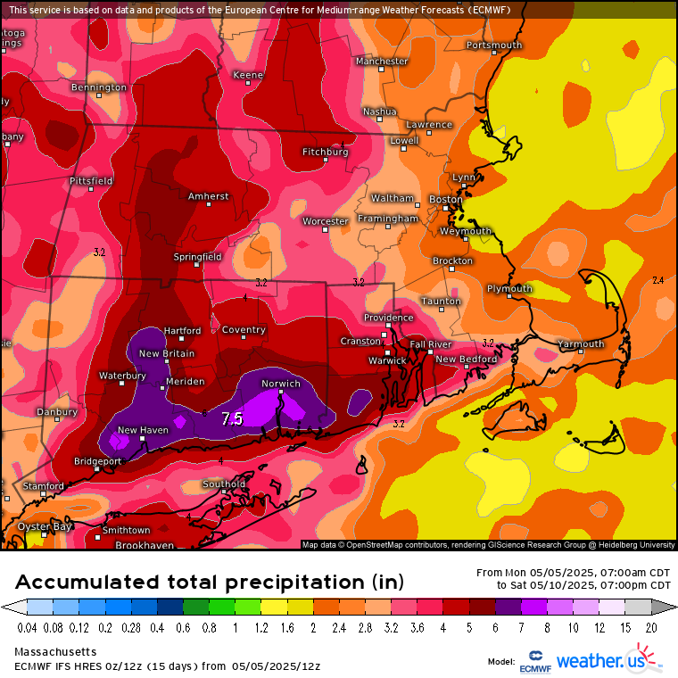
2.16” so far for the entire event. we need a lot more.
-
Actually it would cause an enormous increase in global temperatures from the heat of the fusion reactions. Followed by a global firestorm similar to that after Chicxulub. Many months later when the fires smolder out and dust blocks the sun, then the nuclear winter begins.


.thumb.JPG.418e8a9a2902ae687ec35ff4bc0e038e.JPG)


