All Activity
- Past hour
-
 it's winter in the summer. Someone seems bound though to get some good rains but I'm a little skeptical of widespread amounts that high like the NAM has.
 -
 If this was winter these wet n wild Mets would be so conservative when they should be gung ho. In summer it’s rains gone wild when so many things could go wrong . Interfering to note
 -
 Congrats Dendrite
 -
With convection involved in the mid Atlantic. Proceed with much caution on big amounts
-
He’s well aware of my thoughts . Thanks for your obsession
-
Several mesonet sites in the eastern shore and southern MD are running ahead of yesterday.
-
That is going to be they key I think to where the heaviest totals occur. Have to see where that sets up but sort of seems like that may be just north of SNE. We get into the heavy rains as it moves through but this might be maximized just north. I foresee one big band of rain lifting north then more showery
-
 Yeah 36 hours of that 850 fgen.... with 2" pwats on the south coast.
 -
Not as hot here yesterday at the same time. Clouds
-
Also should start to see some cumulus start to form in the next couple hours. Already popcorn storms over the higher elevations
-
Number of ensemble members pretty close to doubled overnight for the BDL area. I would be more willing to toss if there wasn't a band of warm advection f-gen on all models.
-

2026 Mid-Atlantic Severe Storm General Discussion
Ellinwood replied to Kmlwx's topic in Mid Atlantic
Cap won yesterday. Less of an issue today despite the lower dews, but given the uncertainty with the placement and coverage of storms, I'm a little surprised to see the 45% from SPC today (though they kept me in a Slight at the 00z update last evening despite it being clear nothing was gonna happen after 00z). I do think whatever storms do form will likely overperform because we haven't had any turnover in the atmosphere since the start of the heatwave. Congrats to whoever gets the storms today (assuming it doesn't cancel your plans). I think we get scattered storm coverage with stuff that comes in off the mountains, but where those end up exactly is my biggest uncertainty.- 923 replies
-
- 1
-

-
- severe
- thunderstorms
- (and 7 more)
-
95 / 65 here
-
 Good luck with your half inch.
 -
This is a big/strong signal for big rains.
-
Great Falls 4th of July parade was hot but fun as always. Glad they didn’t cancel for the heat!
-
 I would tend to agree-but models seem to be moving towards that solution for whatever reason right or wrong.
 -
Nams & hrr actually look pretty good for the city and Long Island til late night
-
 NH Seacoast special later today?
 -
https://www.capitalweather.com/100-degree-days-in-washington-d-c/ 1930 had 11 2012 had 8
-
(002).thumb.png.6e3d9d46bca5fe41aab7a74871dd8af8.png)
Central PA Summer 2026 Discussion/Obs Thread
ChescoWx replied to Voyager's topic in Upstate New York/Pennsylvania
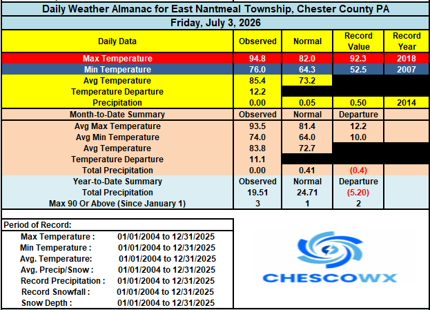
Thank you so much!!! I appreciate all the folks that post in this forum and others!! -

2026-2027 Super El Nino
snowman19 replied to Stormchaserchuck1's topic in Weather Forecasting and Discussion
Bjerknes feedback in full force. And yea, the EPAC is about to be off to the races with TC’s this month too -
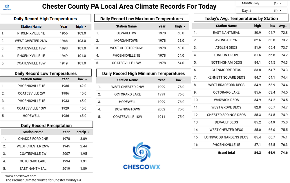
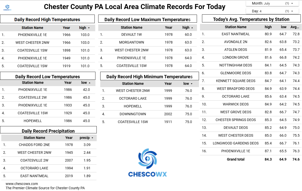
July 4 1999: Severe winds knock down millions of trees in the BWCA, injuring 19 people. Note: You can read about this event here: https://www.weather.gov/dlh/July_4_1999_BWCA_Storm 1962: An extremely heavy downpour falls at Jackson, dumping 7.5 inches of rain in two hours. For Saturday, July 4, 2026 1776 - Thomas Jefferson paid for his first thermometer, and signed the Declaration of Independence. According to his weather memorandum book, at 2 PM it was cloudy and 76 degrees. (David Ludlum) 1911 - The northeastern U.S. experienced sweltering 100 degree heat. The temperature soared to 105 degrees at Vernon, VT, and North Bridgton ME, and to 106 degrees at Nashua NH, to establish all-time records for those three states. Afternoon highs of 104 at Boston, MA, 104 at Albany, NY, and 103 at Portland, ME, were all-time records for those three cities. (The Weather Channel) 1956 - A world record for the most rain in one minute was set at Unionville, MD, with a downpour of 1.23 inches. (The Weather Channel) (The National Severe Storms Forecast Center) 1987 - Thunderstorms around the country provided extra fireworks for Independence Day. Thunderstorms produced wind gusts to 82 mph at Clearwater, KS, eight inches of rain in four hours at Menno SD, and three inches of rain in just fifteen minutes at Austin, KY. Morning thunderstorms drenched Oneonta AL with 8.6 inches of rain, their greatest 24 hour total in thirty years of records. The heavy rain caused mudslides and serious flooding, claiming two lives. (The National Weather Summary) (Storm Data) 1988 - Thunderstorms produced heavy rain over the Central Gulf Coast Region for the second day in a row. Monroe, LA, was deluged with 3.75 inches in two hours. Aberdeen and Rapid City, SD, reported record high temperatures for the date, with readings of 105 degrees. (The National Weather Summary) 1989 - Independence Day was hot as a firecracker across parts of the country. Nineteen cities, mostly in the north central U.S., reported record high temperatures for the date, including Williston ND with a reading of 107 degrees. In the southwestern U.S., highs of 93 at Alamosa, CO, 114 at Tucson, AZ, and 118 at Phoenix, AZ, equalled all-time records for those locations. (The National Weather Summary) Observances: (Note: Timely observance with sidewalk egg frying day for some out East.) 4 Sat National Sidewalk Egg Frying Day 4 Sat Independence Day 4 Sat International Day of Cooperatives 4 Sat Alice in Wonderland Day 4 Sat Filipino-American Friendship Day 4 Sat Fourth of July 4 Sat Independence From Meat Day 4 Sat Indivisible Day 4 Sat Jackfruit Day 4 Sat Invisible Day 4 Sat National Barbecued Spareribs Day 4 Sat National Grill Safety Day 4 Sat National Hillbilly Day 4 Sat Sidewalk Egg Frying Day 4 Sat National Caesar Salad Day
-
 Looks like my heatwave winds up being 93-93-93. Pretty neat. 87 or so for the high here today.
 -
Central PA Summer 2026 Discussion/Obs Thread
ChescoWx replied to Voyager's topic in Upstate New York/Pennsylvania
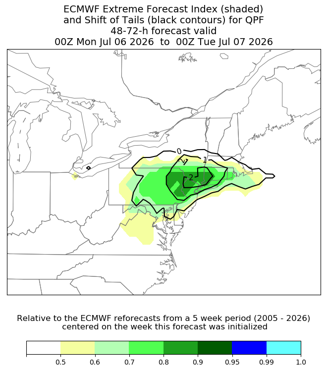
Happy Independence Day to all!!! Well while today will still be sweltering it will be a few degrees cooler than yesterday. Real relief arrives tomorrow as temperatures fall back to near normal levels for early July with highs in the mid-80's. We will see temperatures fall to below average by Monday and continue through the middle of the week. Shower chances start to increase this evening, but I think the best chances for rain will be after fireworks. Rain chances really increase Sunday night into Monday morning. Some spots could see between 1 to 2 inches of much needed rain.