All Activity
- Past hour
-
Picked up a quarter inch after midnight, with more storms incoming. I mean, could someone turn off the rain machine in my area please?? Send it east where it's still needed.
-

2026-2027 Super El Nino
Stormchaserchuck1 replied to Stormchaserchuck1's topic in Weather Forecasting and Discussion
I'm really starting to miss the Daily Climate Composite maps, as current SSTA configurations could start giving us clues about the cold season NAO and WPO, and SLP maps over the Arctic, an indicator of cold season AO. -
How? It hasn't been bad at all yet and we had snow a few weeks ago
-
2026-2027 Super El Nino
Stormchaserchuck1 replied to Stormchaserchuck1's topic in Weather Forecasting and Discussion
Here's an interesting stat: 13 straight February's with +NAO (CPC). 10/13 have been >+1.00. For comparison, our last Winter month (DJFM) with any monthly NAO <-1.11 was Dec 2010. -

2026-2027 Super El Nino
40/70 Benchmark replied to Stormchaserchuck1's topic in Weather Forecasting and Discussion
They still haven't calculated the QBO since February. What an absolute nightmare this administration is. -
-

Central PA Summer 2026 Discussion/Obs Thread
Voyager replied to Voyager's topic in Upstate New York/Pennsylvania
Thanks. I'm new to this as I was just diagnosed a week and a half ago. I guess when I have my follow up appointment, medication suggestions and diet will be discussed. -
SLGT risk up for Monday on afternoon Day 3 @high risk @Kmlwx @Eskimo Joe ...Mid-Atlantic... Areas of showers and thunderstorms are expected to be ongoing Monday morning across the lower Great Lakes/upper OH Valley region. Ahead of that convection, a southwesterly low-level jet is forecast to migrate through the Mid-Atlantic, enhancing the poleward transport of an increasingly moist and unstable boundary layer. Increasing height falls/forcing for ascent coupled with convergence near and ahead of the surface low, cold front, and any existing outflow boundaries are expected to foster an increase in storm coverage and intensity by afternoon. Strengthening mid-level flow aloft will combine with backed, near-ground winds ahead of the surface low to enhance vertical shear across the DelMarVa region, supporting the potential for supercell storm modes capable of all severe-weather hazards.
-
Central PA Summer 2026 Discussion/Obs Thread
Porsche replied to Voyager's topic in Upstate New York/Pennsylvania
I’ve been dealing with this for around 30 years. Under control with medication and no diet restrictions, although I pay for ice cream if too much. Need any info, DM me. -
2026-2027 Super El Nino
40/70 Benchmark replied to Stormchaserchuck1's topic in Weather Forecasting and Discussion
WPO....it's usually + in these uber warm ENSO events, but 1982-1983 was negative....I could see us pulling that off again given the recent changes on the North Pacific. May be another notable difference between this year and 2023-2024. -

2026-2027 Super El Nino
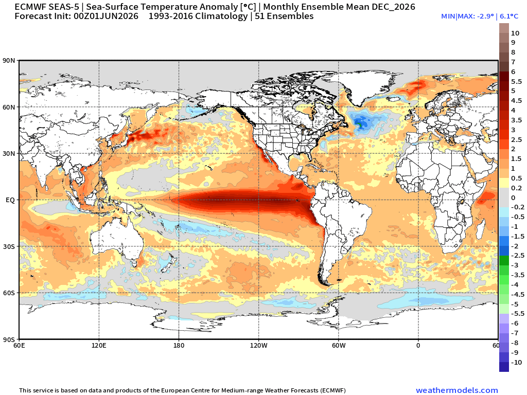
bluewave replied to Stormchaserchuck1's topic in Weather Forecasting and Discussion
The December forecast map shows the +IOD becoming more neutral following the fall peak with the SSTs rebounding a bit near the Maritime Continent So we’ll have to see how things verify once we get that far out in time. Also note the December forecast chart has warmer SSTs east of Japan and over the Atlantic.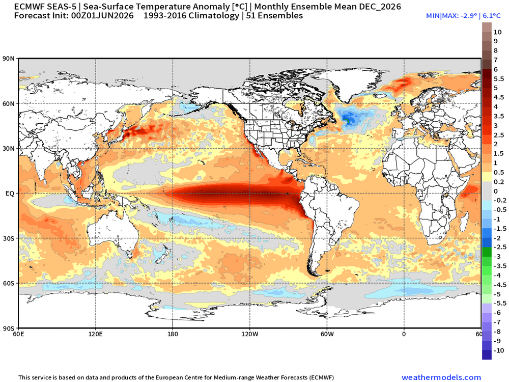
-
Looks like an inch of rain is possible tomorrow for this area. 2-3" rains possible south of I-80.
-
acatt having a rough summer
-

Central PA Summer 2026 Discussion/Obs Thread
canderson replied to Voyager's topic in Upstate New York/Pennsylvania
Well true but if that stuff is what makes you to feel horrible at least you know! -
It will be warm but not hot and humid like some are thinking.. average to slightly below temps but also looks like we get into a wetter pattern..
-

2026-2027 Super El Nino
snowman19 replied to Stormchaserchuck1's topic in Weather Forecasting and Discussion
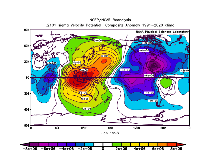
All the January, 1998 -NAO/-AO did was trap Pacific air underneath the blocks - Today
-
don't really buy the slight risk being pushed into Ohio tomorrow, ample shear but MLCAPE will likely be below 300j/kg. like wednesday's event on a budget.
-
2026-2027 Super El Nino
40/70 Benchmark replied to Stormchaserchuck1's topic in Weather Forecasting and Discussion
1957-1958 also had quite a bit of -NAO.....but Chris is correct to question how effective it would be today because even if the west warm pool relents, we still need to account for the exaggerated ridge and attenuated trough responses in our modern climate. -
2026-2027 Super El Nino
40/70 Benchmark replied to Stormchaserchuck1's topic in Weather Forecasting and Discussion
Never any guarantees with an El Niño that powerful, but we can all agree that we'll need some negative NAO to have an appreciable shot. -
2026-2027 Super El Nino
bluewave replied to Stormchaserchuck1's topic in Weather Forecasting and Discussion
Even a -NAO -AO during a super El Niño can be warm with very little snow like we saw in January 1998. The issue was how strong the El Niño ridge was in the Great Lakes into the Northeast to the south of the block over Greenland. Also note that the forcing to the east of the Dateline didn’t help since it was so strong.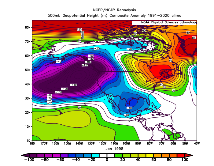
-
2026-2027 Super El Nino
40/70 Benchmark replied to Stormchaserchuck1's topic in Weather Forecasting and Discussion
I would welcome this, regardless of how we fare this coming winter. -
2026-2027 Super El Nino
40/70 Benchmark replied to Stormchaserchuck1's topic in Weather Forecasting and Discussion
Yea, that's more of a traditional, canonical-intense El Niño response, more in line with 1997. NAO will be crucial to salvaging a winter. Probably cooler than 2023 in the NE in the absence of that competing MC element. -
2026-2027 Super El Nino
snowman19 replied to Stormchaserchuck1's topic in Weather Forecasting and Discussion
Nice write up. Been saying it, but in addition to the east-based super Nino, +IOD, maybe slightly +PDO and -AMO, the Copernicus suite is showing the 30C isotherm getting pushed all the way to 140W, which would be the first time it history, the previous record being 155W. If that actually happens, it would effectively end the “split forcing” that we saw in 2015-16 and 2023-34. IMO, given these basically non stop major WWBs and DWKWs since April, which look to continue, that entire equatorial WPAC/Indo warm pool gets sloshed/shunted east (finally) -
I'm forecasting 1" with locally higher amounts along I-78 on northward at the moment. We'll watch for subtle shifts. At a minimum I think 1/2" - 1" looks pretty solid between the I-78 - I-90 corridor. With locally higher amounts. I'll be disappointed with anything under 1". Sunny parts of the lawn not reached by sprinklers are taking it on the chin. Looking terrible. If this keeps up much longer I'm worried NJ will issue mandatory restrictions and start banning all but essential irrigation as we head through July.
-

2026-2027 Super El Nino
BlizzardWx replied to Stormchaserchuck1's topic in Weather Forecasting and Discussion
And it's worth noting it's not just really warm vs less warm. ECMWF seasonal shows genuine cool anomalies near the MC as part of that +IOD along with the eastward leaning nino. I think if this roughly happens it really would kill the split forcing Bluewave is always talking about. Even further north the ECMWF seasonal is mostly breaking down the warm water in the west Pacific with what is a neutral to maybe slight +PDO look. This would be a genuine change from the last decade. And that's to say nothing of what still looks to be a marginally negative AMO.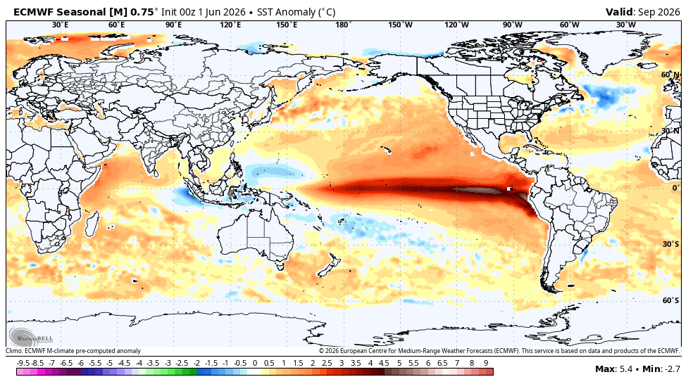


.thumb.gif.f92b16c631a1d15d405ed77b33f0710d.gif)


.thumb.jpg.ad3a2e31d30aff035044689b311a0540.jpg)
