All Activity
- Past hour
-
He promised not till next December though if we get this one.
-
Where I agree with you is that if you pre-define a synoptic setup as simple (moist southerly flow into a cold dome), then it is comparatively simple. We do get hung up on semantics. But I also think we oversimplify and broad-brush weather events with terms that are too general.
-
Down to 34 here - breezy
-
Oddly enough once the snow stops he doesn't care. He will complain 3 days after a HECS though if there is nothing else to track on the models
-

Another Coating of Snow Saturday - "It's all we Got"
Spanks45 replied to Sey-Mour Snow's topic in New England
Yeah, one of these years we will make a run....I scored more 16"+ events living in Delaware for 7 years than I have being up here for 10 years...odd times -
The temp is falling during the afternoon here as expected. Down to 34 now. Wind feels very cold.
-
Almost 2:30 pm and I've 'warmed' to 22.9/8.0. In and out of clouds and occasional flurries with NW 20-30 mph winds. Feels quite wintery.
-
Holding out hope:
-
I did start the one last year that turned into the RDU-NE NC storm so I was riding a hot streak. Kinda like Riley reeling off wins vs app state and wake I thought I’d figured it out
-
Sledgehammer and we all know it would probably be Ji
-
Imho thats going to be more an Aleutian low signal than an Alaska proper vortex. That look presented actually gets us in +PNA territory and verbatim would move the PNA ridge axis near the benchmark (Idaho iirc). I would be ok with the epo easing a bit as this look takes shape going into the waning days of Jan/early Feb. One thing seems certain at least, anyone that declared winter over is likely in for a rude awakening shortly.
-

First Legit Storm Potential of the Season Upon Us
eduggs replied to 40/70 Benchmark's topic in New England
I disagree with this. ECMWF and NOAA/NWS should be the baseline. AI can use verification to improve modeling beyond the current state of physics-equations-based modeling, which is limited by its programming and unable to quickly iteratively improve. -

2025-2026 Fall/Winter Mountain Thread
strongwxnc replied to Buckethead's topic in Southeastern States
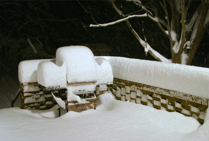
I know some where expecting more for sure out of last night. Great pics Buckethead!! -
Cold dry winters were always a thing.... but it hurts that much more when 80% of our winters are warm now...we can't afford to waste cold ones.
-

Central PA Winter 25/26 Discussion and Obs
pasnownut replied to MAG5035's topic in Upstate New York/Pennsylvania
Gotcha. sounds like a little road trip will lift your spirits. Thats how I get by when winters suckin down here...head north or northwest. -
Here in Chesterland, I believe at least 15” fell as of now with 3’ drifts against the front of my house. Easily the heaviest snow here since 12/2020!!
-
This... the trough is there on our big storm composite look...which as you say is why our big storms tend to come at the end of cold periods and are usually followed by moderation...because the trough there temporarily creates the perfect longwave configuration for a big amplification along the east coast but also leads to warmer air invading the CONUS shortly after...but it doesn't necessarily always have to torch or the warmup doesn't have to last...depends how things evolve from there. But if we do finally get a big snowstorm I'm gonna hit the first person who says "But it all melted a week later" over the head with a tack hammer.
-
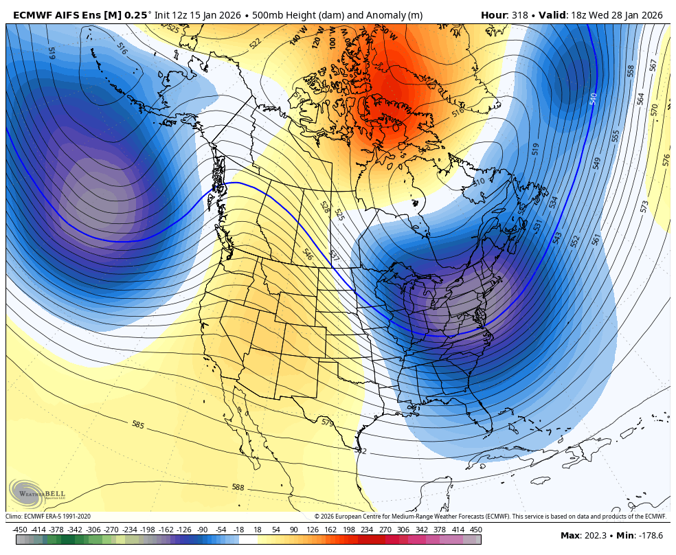
The biggest thing is that northern stream vortices are out of phase w/ STJ energy. The EURO AIFS shows what happens when they are in phase.
-
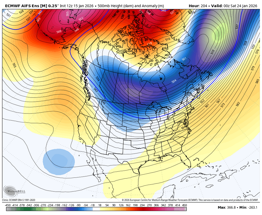
See the panel I posted above. See the wall of HP to the north? Wont be so many pieces of vorticity flying around and digging southward, so simpler perhaps. Look at what we have for the upcoming (non) event compared the advertised h5 look for around the 24th- Still could have some vorticity rotating southward from the TPV, and that would provide confluence as the shortwave in the SW moves eastward- too much of that could be suppressive. There are always obstacles to our ultimate goal lol.
-
I can only hope your replacement stirs more excitement than his did. I know I want be starting any threads. The one time I did turned out about like this one is looking.
-

First Legit Storm Potential of the Season Upon Us
MegaMike replied to 40/70 Benchmark's topic in New England
Thanks, dude. I always think of Ian Malcolm's quote from Jurassic Park when AI models are mentioned: Data scientists are so "preoccupied with whether or not they could, that they didn't stop to think if they should." I think they're more useful for climatological/ensemble purposes. Its resolution is too course for nowcasting, and whether people like it or not, the best real-time product we have is the HRRR (only model to update every hour not considering the RRFS). Users just need to understand its limitations... Within a few hours = good ||| outside a few hours = meh ||| beyond a PBL cycle = ignore... I've been thinking; theoretically, the ceiling for AI should be that of current NWP... I don't think it's possible to outperform the dataset its trained on, so to improve AI, you must improve NWP <OR> increase the size of your training dataset. As a result, NWP will never be phased out. :fist bump: If I remember correctly, the evaluation was conducted wrt an analysis dataset (not in-situ locations). To me, that implies they're evaluating its efficacy (can it 'hang' with a traditional modeling system?) and not its accuracy. I did this too when I compressed assimilation data and reran CMAQ simulations when I worked with the EPA. I won't trust AI until evaluations are conducted at remote sensing stations. Analysis datasets aren't entirely accurate. -

Pittsburgh/Western PA WINTER ‘25/‘26
colonel717 replied to Burghblizz's topic in Upstate New York/Pennsylvania
I grew up in West Mifflin. Over by the Community College. That's a far drive for you. -
the Pacific trough pumps the PNA... that's part of the reason why it usually torches after big storms as the jet overextends
-

January 2026 regional war/obs/disco thread
brooklynwx99 replied to Baroclinic Zone's topic in New England
yup. first, moisture pushing into a cold dome and then a shot at a retrograding block to end the month. can't ask for more at this range
-
Not great to see that trough build in so quickly over Alaska?