All Activity
- Past hour
-
If they're in line for an inch of ice they should be wishing for it too.
-
Was boiling water yesterday. This bitter air is desert dry. Some of you may wish to do that in the next days to keep humidity up.
-
With so many events, we tend to see the 06z guidance waffle or dry up. With the 06z Euro et al beefing up, it's a great sign. We're almost at the point where a "fail" would only be 4" - 8".
-
Currently in a PI refinement session. I tried to start the convo off talking about the upcoming snowstorm. Worked for a couple mins…but yea, paychecks are important, too.
-
Oh hello
-
This is banter, they can say whatever they want. Just like what Webb was doing yesterday, save us the trouble. We're looking at synoptics and quite literally reporting on what the trends are.
-

January 25/26 Jimbo Back Surgery Storm
neatlburbwthrguy replied to Jimbo!'s topic in Southeastern States
Where can I read Allan’s thoughts? -
And now my daughter texted that “people are saying like a foot of snow”
-

January 2026 regional war/obs/disco thread
mahk_webstah replied to Baroclinic Zone's topic in New England
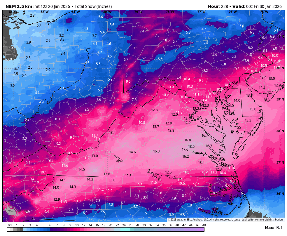
I think this is a useful analysis because I tend to think that when they amp up, they move north and that is obviously not always the case. But just as someone who’s been watching the storms for four decades I think this will end up north of the baseline and southern New England will probably get a 6 inch plus snowstorm. -
Wow what a great looking storm! That cold air really does look legit here. In some ways this reminds me of the Feb 2011 storm. I think that's the one anyways. A lot of NC ended up with around 4-8 inches of snow and like an inch or two of sleet. Rooting for you guys!
-
SE forum accusing us of wish casting that this comes north…
-
There's always a silver lining somewhere
-

Central PA Winter 25/26 Discussion and Obs
paweather replied to MAG5035's topic in Upstate New York/Pennsylvania
For sure stayed up for the EURO this morning might try to get some sleep tonight before staying up the rest of the week with naps lol -

Central PA Winter 25/26 Discussion and Obs
mahantango#1 replied to MAG5035's topic in Upstate New York/Pennsylvania
Sleepless nights are certain for the rest of this week. -
This not going to happen but my weather channel app shows possibly 15”-22”. Lol
-

Richmond Metro/Hampton Roads Area Discussion
Conway7305 replied to RIC Airport's topic in Mid Atlantic
2016 was epic. Hard to believe we are right at the 10 year mark about. I live near Short Pump and we had 16 inches. Beautiful Storm -
a balmy 14 early this morning
-

Texas 2026 Discussion/Observations
DFWWeather replied to Stx_Thunder's topic in Central/Western States
Good analogs to this event synoptically are Feb 2003 and December 2013 with this event producing potentially more QPF and a much colder and denser Arctic airmass entrenched. The H5 pattern is one of the 4 classic setups that gives North Texas significant snow/ice. This will likely be a sleet maker initially with snow on top, and I wouldn't even rule out some freezing rain accretion at start. I do expect the change over to be quicker timing than currently advertised by FWD, probably more late morning early afternoon on Friday. We'll know a lot more when in range of the NAM. Too early to try and call accumulations right now with precip type and phase changes unknown at this range. -

Richmond Metro/Hampton Roads Area Discussion
RVASnowLover replied to RIC Airport's topic in Mid Atlantic
Impressive to say the least!
-
Classic overrunning. There will likely be a finger of precip that pushes out ahead of the main round due to the forcing aloft. When you have a dense cold dome at the surface and a screaming Jetstream at 300mb, it doesn't take much to generate precipitation. Notice it coincides with the surface front screaming in from the parent HP.
-
Found a -26 in Lind, WI, which is NE of Rush City, MN near the St. Croix river.
-
The audacity of this place that gives me a check for working expecting me to work on a day like today. Busy morning, but calming down. NAM looks good...now we await the king of models...the ICON
-
A $5,000 disaster for my trees was November, 2018
-
The Euro solution isn't necessarily less snowy, it's just slower (at least the 6Z run). There's more to come - possibly much more to come - after 144.
-

1/23/26-1/25/26 Winter Storm Thread
Save the itchy algae! replied to AMZ8990's topic in Tennessee Valley
A little off topic here, but I just went over to the mid Atlantic board to see where their heads were at on the storm and let me just say that they were giving nazi-esque vibes with their over moderation. I appreciate this board with 100% sincerity.