All Activity
- Past hour
-

September 2025 OBS-Discussion centered NYC subforum
bluewave replied to wdrag's topic in New York City Metro
The record ridge and drought in Canada generated strong high pressure and low dewpoints. This was followed up by the record trough over the Western Great Lakes ago. These very cold early season temperatures are actually being driven by the minimums allowing ideal early fall radiational cooling. We should continue with the comfortable early fall temperatures here right into mid-September as Canadian high pressure dominates. But much the CONUS is experiencing expanding drought conditions. So we could see a drought feedback warm up beginning to west while we enjoy the great early fall weather here. Unfortunately, the reliable models only go out 15 days. So the pattern from late September into October will depend on the pattern evolution. If we start getting more high pressure to our SW, then that drought feedback warmth could arrive here later September into October. Statistically we don’t see much 90° heat here at the warm spots like Newark that late in the season. We haven’t seen any 90° heat at these locations that late since 2017 and 2019. But you never know if this will be the first 2020s year to pull it off. Especially if the winds can turn more SW. The big theme here in recent years has been record 80s warmth right into late October and early November like last year. -
45° for the low here. Love this weather
-
10/10 out there. Only picked up 0.4" this weekend but that's enough to keep the grass growing and prevent more burnout for a couple days. Long range, CPC has us in normal to slightly above normal precip after the 15th... we'll see
-
Snow plows are out in NYC. Winter is coming!
-
-

September 2025 OBS-Discussion centered NYC subforum
TheClimateChanger replied to wdrag's topic in New York City Metro
Can definitely see that immediate, incredible impacts of that sensor change at FFC, which occurred on July 31, 2024. Based on this data, some locations may have cooled as much as 3.5 or 4F with the new sensors, but perhaps the aspiration was broken at the FFC site. They also changed (or are in the process of changing) the aspiration and solar radiation shields. Still even low temperatures dropped precipitously compared to ATL. June 2024 FFC: 92.9/68.2 ATL: 91.1/71.8 July 2024 FFC: 92.4F/73.0 ATL: 90.7/74.0 August 2024 FFC: 90.2/67.3 ATL: 92.0/72.3 Wow! ATL was 2.0F above 1991-2020 in August 2024, while FFC was 1.1F below 1991-2020. -
It is like Ireland here. Every single storm and rain event hit hard. Should be best foliage season in many many DJT years locally. Had the lawn aerated and overseeded this morning.
-

Summer 2025 Medium/Long Range Discussion
A-L-E-K replied to Chicago Storm's topic in Lakes/Ohio Valley
EPS look consistently mild/warm but not seeing any death ridge heat either blessed -

September 2025 OBS-Discussion centered NYC subforum
FPizz replied to wdrag's topic in New York City Metro
What does this have to do with this forum? Go cry in theirs. Also, all the bitching in the world doesn't matter, see NYC. It never gets fixed. If they don't care, why should we. -
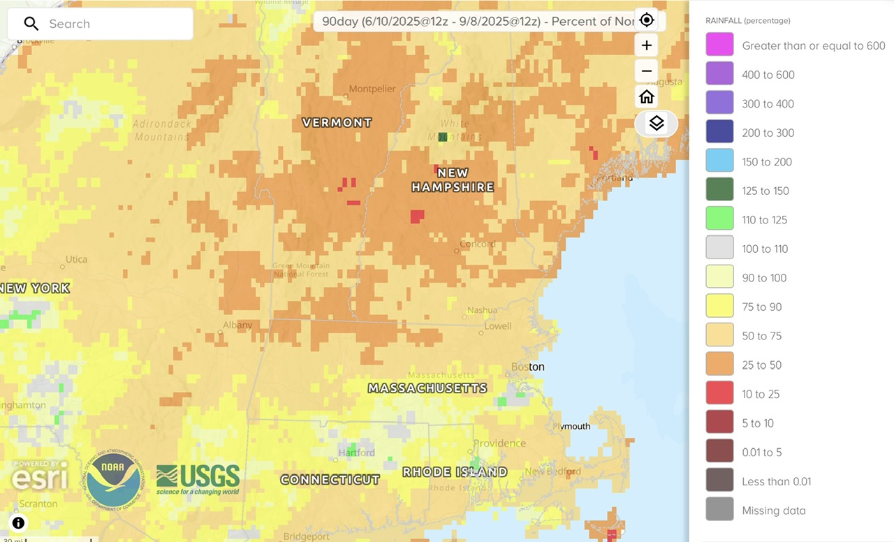
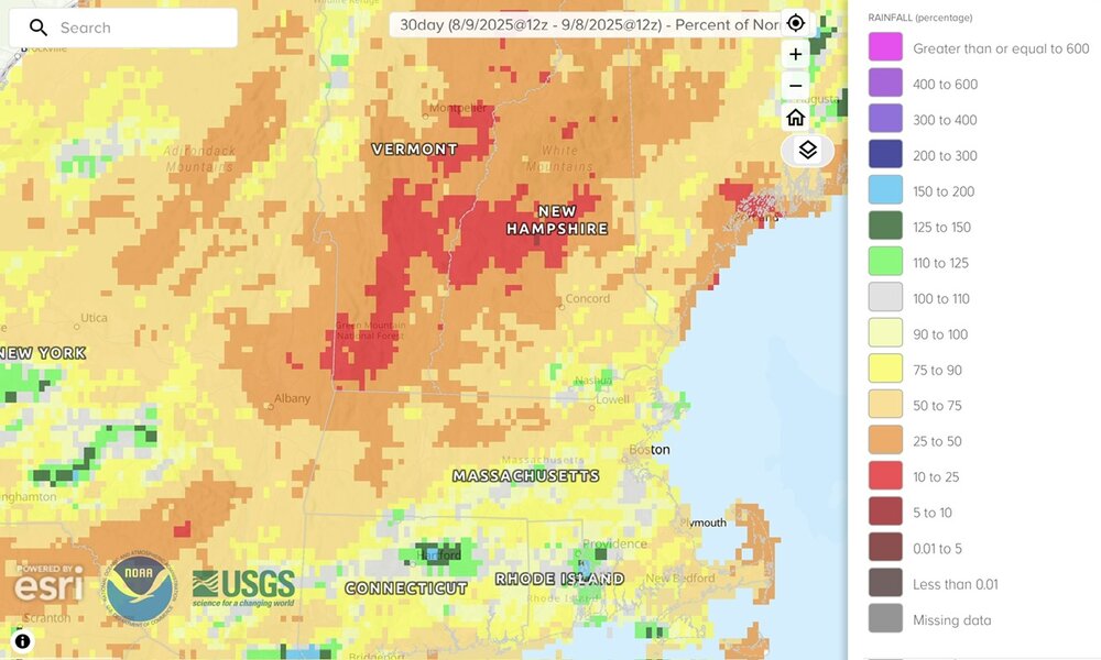
% normal precip…last 30 days and 90 days Water pouring out of hills in Tolland while grass spontaneously ignites here. The foliage looks like it’s 3-4 weeks ahead.

-

Summer 2025 Medium/Long Range Discussion
madwx replied to Chicago Storm's topic in Lakes/Ohio Valley
3rd coldest 9/1-9/8 in MSN this year. But things are about to change drastically, wouldn't be surprised if we end up with an above average departure at the end of the month -
What a stretch upcoming.
-
September 2025 OBS-Discussion centered NYC subforum
TheClimateChanger replied to wdrag's topic in New York City Metro
What is so funny about this comment? It's a legitimate question/concern. Others have noticed this change as well on other weather forums: New ASOS Temperature/Dewpoint System This user noted that FFC, one of the original test sites, went from running warmer than ATL to colder: This user noted that Valentine (NE) Airport went from quite a bit warmer than his readings to about the same, if not cooler. He also notes the sudden proliferation of 100% humidity which was pretty much non-existent on the traditional sensors. -
finally bagged a low in the 30s, down to 38 this morning. already up to 60 less than 3 hours later though.
-
So far so good with my peak season forecast…
-
Basically, we can take a set of numbers and break them into quarters. Just like we do with the months in a year. Interquartile is the set of numbers between Q1 and Q3, the numbers in the middle of the dataset. So if the models are putting out numbers that are very spread out and uncertain like in your example, the Interquartile Range will be high. If the models are all putting out similar numbers, the difference between Q3 and Q1 will be low, so making a temperature forecast might be easier.
-
September 2025 OBS-Discussion centered NYC subforum
TheClimateChanger replied to wdrag's topic in New York City Metro
Looks like its going to vary widely from site to site. DTW has only cooled about 0.1F relative to its divisional mean, while CLE has cooled about 0.6-0.7F relative to its divisional mean compared to 2024. -
Flatlined as expected after Erin. What’s really interesting though is that this has been a multi-year global trend. The basins have struggled. WPAC in particular.
-
September 2025 OBS-Discussion centered NYC subforum
TheClimateChanger replied to wdrag's topic in New York City Metro
Looking at the observations from Pittsburgh (PIT), it appears to be about a 1F cooling offset. But YMMV by location - definitely something to keep an eye out for. In June 2024, PIT was 72.8F, which was 3.9F above the Pennsylvania Southwest Plateau mean of 68.9F. In June 2025, PIT was 73.1F, which was 2.9F above the Pennsylvania Southwest Plateau mean of 70.2F. In July 2024, PIT was 76.5F, which was 3.3F above the Pennsylvania Southwest Plateau mean of 73.2F. In July 2025, PIT was 77.0F, which was 2.3F above the Pennsylvania Southwest Plateau mean of 74.7F. So it looks like relative to the Climate Division in which it is located, the new sensor shaved off 1F. Of course, the WBAN sites make up a decent proportion of the total stations in nClimDiv such that the offset may bias the divisional means unless it's been corrected by the pairwise homogenization algorithm. But if there is a residual bias in the divisional data, then the actual cooling offset may be a bit more than 1F. This is a big reason why state and divisional rankings were higher this summer than the cities, as the cooperative sites [and other stations] had no change in equipment and thus had more continuity of record. This is a reversal of recent years/decades in which cities tended to rank higher than the corresponding state and divisional data. -
Low of 45.6°
-
Yeah…through d9 lol
-
Yeah I think we have to punt away this season and hope and pray Biscotti finally does what needs to be done. I came into this year skeptical about it being the SB year to begin with--so while it's disappointing it's not surprising!
-
Thursday and Saturday rainfall totaled just .37" here. (.02" on Saturday)
- Today
-
September 2025 OBS-Discussion centered NYC subforum
TheClimateChanger replied to wdrag's topic in New York City Metro
Do you think the new sensors are playing a role in the explosion of record lows? It's been wild to see these airports go from way warmer than everywhere to colder. 100% humidity observations went from basically non-existent to now I'm seeing some of these rural airports having eight hours a night at 100% with no weather (fog, precipitation). -
I think that is also BN too. Erin spiked it up, but we’ve had garbage outside of that.