All Activity
- Past hour
-
It’s actually not too bad currently at jones beach, almost full sunshine. Significantly better then this morning.
-
Oh good, more rain moving in.
-
heard that. long range looks promising... didn't think i'd have to say that between march and november
-
-
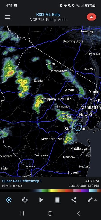
Most of the higher totals are to the South. A winter pattern.
.gif.0e63b9cdbe42594318c1f588858230f5.gif)
-
It would be in the upper 20s/low 30s in January rn…and I’m glad it’s not.
-
These stuck weather patterns are the bane of my existence. It helps with sleeping though because #depression. I see NYC beaches open this weekend... Ready for the polar plunge?
-

2025-2026 ENSO
Stormchaserchuck1 replied to 40/70 Benchmark's topic in Weather Forecasting and Discussion
The AMO may have an imapact: -AMO ibb.co/bR3LvKW+AMO ibb.co/KctZCPm-AMO ibb.co/wKX4YCC+AMO ibb.co/sFSwm0j I don't know what the numbers are at 40N.. Maybe it is +3F. +WPO flexes the SE ridge further north, and as Ray pointed out it has been positive every Winter but 1 since 16-17 I don't think that we are seeing more of a SE ridge because of global warming. I think that whatever the global temperature increase is divided by latitude is what that impact is. -
Hopefully it misses me, we have a lot of deep blue sky. I got rid of my lawn at this house years ago. I hate grass lol.
-
hopefully we don't get that here, there are large patches of deep blue sky here, I only see a bank of clouds to my north, so all the bad weather must be up there far away from me lol
-
Little shower approaching here and the trajectory of the showers to NW moving SE look promising (though it might miss to my north). My lawn is loving all this water.
-
Hey Chuck, -A pro met at (the former?) Maxar who I keep in touch with on occasion blamed the increased SE ridge tendency a few years ago on the disproportionately very warm western equatorial Pacific. -Also, I’ve seen some others give a portion of the blame to the +AMO. -Wasn’t GW closing in on +2.5 to +3.0 F after that big 2023 spike?
-
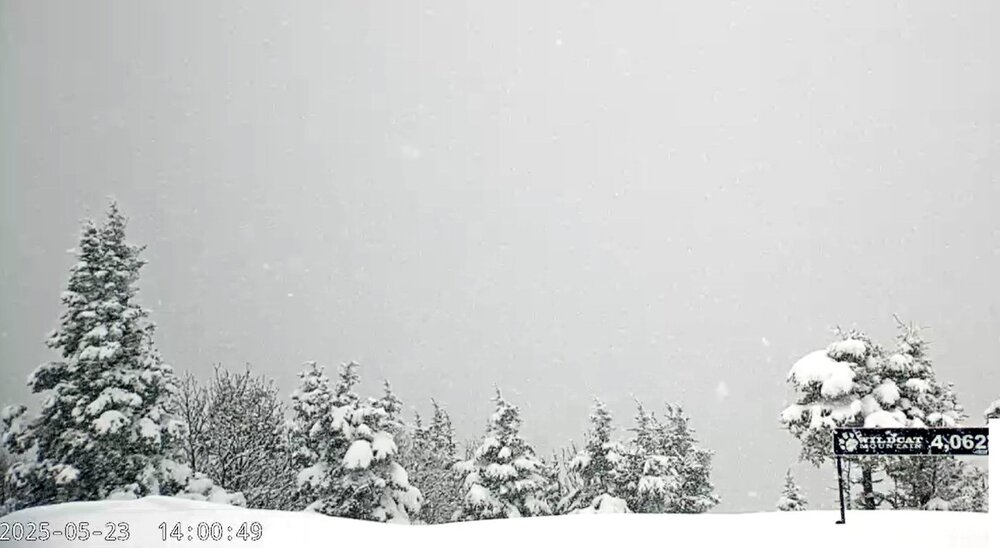
I always loved taking the lift up to Wildcat's summit. It can get wild in that final stretch, no pun intended. Like a different world up there.
-
Sipping on a Limited Release 120 min IPA to start the long weekend. Glorious weather the next few days. Probably wont have this again until early October lol.
-
You glad you installed in April yet?
-
2025-2026 ENSO
Stormchaserchuck1 replied to 40/70 Benchmark's topic in Weather Forecasting and Discussion
I'm tired of global warming being blamed for the Winter SE ridge, especially during -AO/-NAO periods, when the Pacific has been in +WPO/-PNA. This map makes sense to me in regard to those 2 patterns and downstream effects. Global warming makes a +2F overall difference, but that's about it. It's not some unicorn pattern that is causing new things, like a more impactful SE ridge. There is meteorology involved, everything that happens has a reason. The global warming effects are global, but not localized. -
Was sunny here then out of nowhere started raining again
-
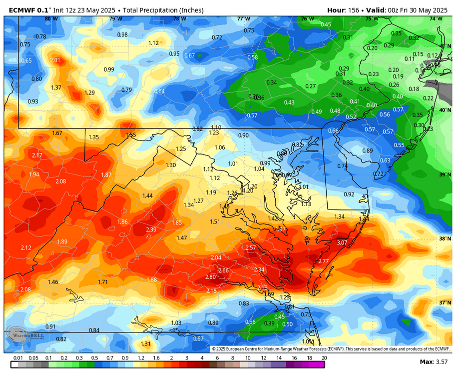
WB 12Z EURO shows another Wed. storm this upcoming week.
-
2025-2026 ENSO
Stormchaserchuck1 replied to 40/70 Benchmark's topic in Weather Forecasting and Discussion
That map is the SST profile May-July that leads the Winter WPO.. positive phase, although it has correlated with -PDO more so in the last 8 years. -

E PA/NJ/DE Spring 2025 Obs/Discussion
BBasile replied to PhiEaglesfan712's topic in Philadelphia Region
7-10 split.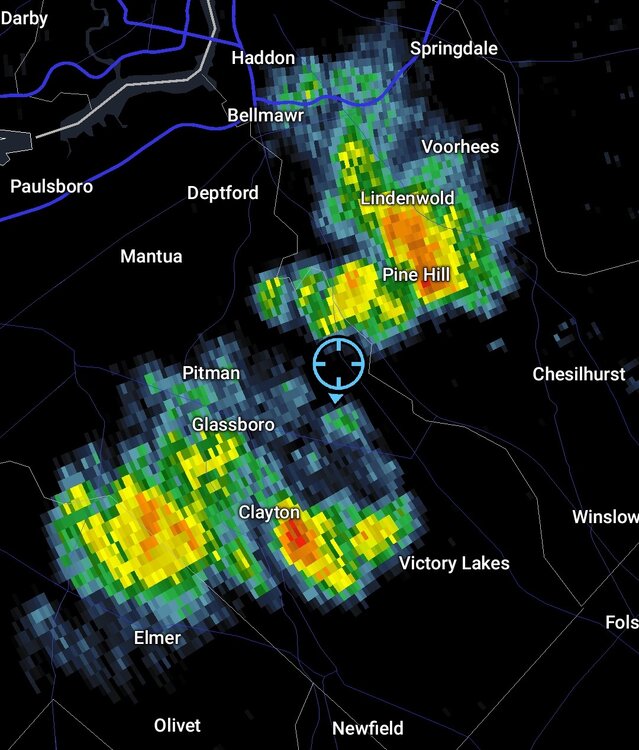
-
2025-2026 ENSO
Stormchaserchuck1 replied to 40/70 Benchmark's topic in Weather Forecasting and Discussion
Not according to this https://www.longpaddock.qld.gov.au/soi/ -
It would be nice if we could reach 60 tomorrow. Fingers crossed.
-
had some light showers move through here-sun line approaching though on satellite
- Today
-
The summit of Wildcat probably has over 6"
-
Not today though, the sun has been out for awhile and has heated everything up nicely.

.thumb.png.4150b06c63a21f61052e47a612bf1818.png)


