All Activity
- Past hour
-
Yeah it was sarcasm. I was still in D1 last week.
-
-
Central Park, so far, 1.26”. The majority in two downpours. As always …..

-

Wet late Monday 6/22 or another Fizzle?
Weather Will replied to Weather Will's topic in Mid Atlantic
You dust yourself off, and look for the next chance. Saturday is still looking like a possible decent rain event. -
The wind with that line of storms was white impressive last night even though here in south Greensboro it wasn't nearly as bad as north Greensboro. What was really usual was how long the wind was sustained, 10-15 minutes of winds gusting to 40-50 mph
-
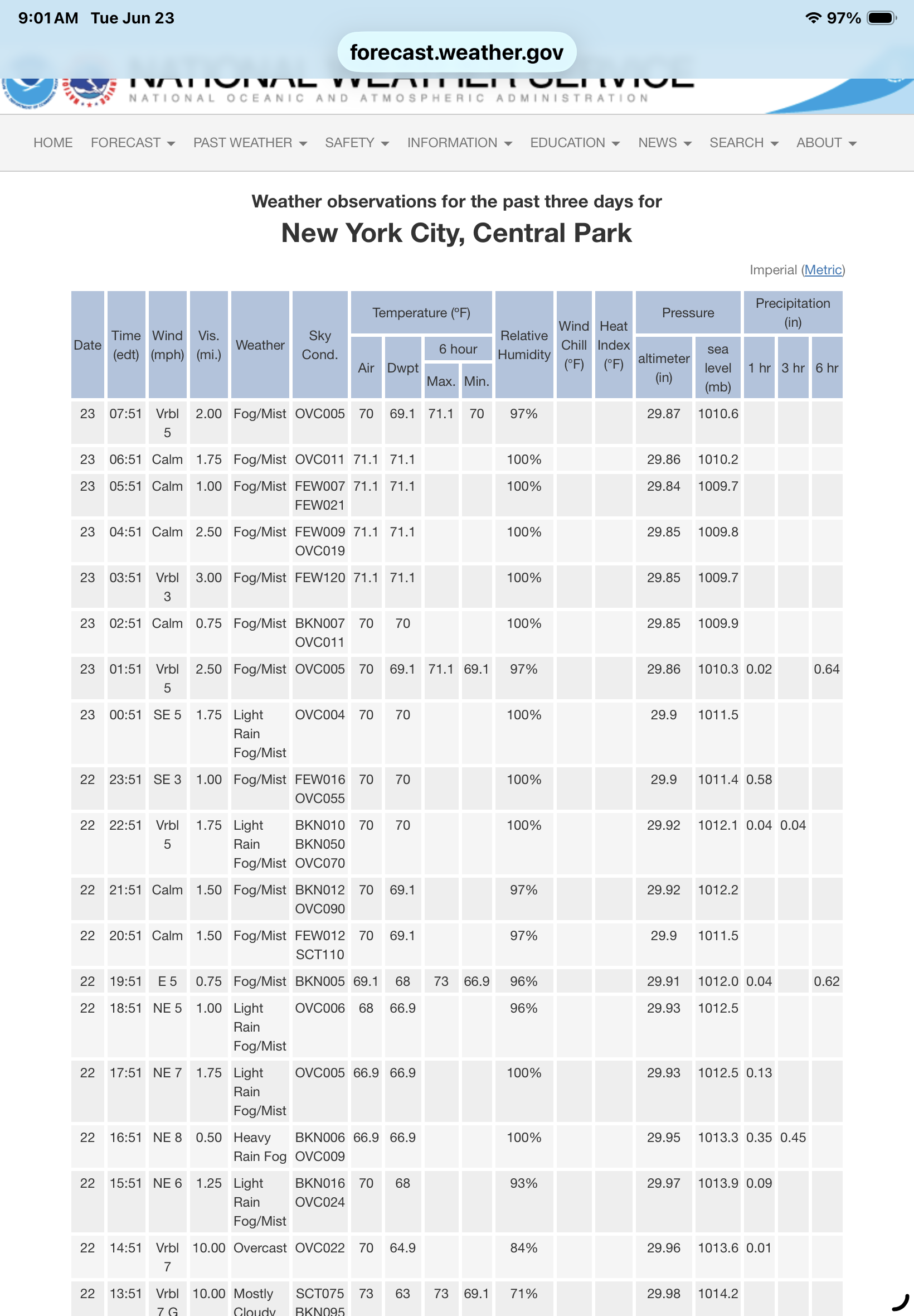
Rain has started back up here. Radar looks somewhat hopeful, however, very muggy out there. 7:51 AM 73 F. Overcast Humidity 90% Wind Speed W 5 mph Barometer 29.86 in (1010.9 mb) Dewpoint 70°F (21°C) Visibility 10.00 mi Last update 23 Jun 7:51 am EDT
-
Many saw very little
-

Wet late Monday 6/22 or another Fizzle?
JenkinsJinkies replied to Weather Will's topic in Mid Atlantic
What went wrong? -
Maybe that is why it doesn't show that blob... LOL
-

Central PA Summer 2026 Discussion/Obs Thread
Itstrainingtime replied to Voyager's topic in Upstate New York/Pennsylvania
I want to publicly pop back to say that you were correct. While most of the eastern half of Lanco was under a warning yesterday afternoon, there were no confirmed severe reports according to the SPC storm map. I apologize for questioning you. I saw the warning and thought that severe weather was underway. The storm sure looked gnarly on radar. -
Wet late Monday 6/22 or another Fizzle?
Weather Will replied to Weather Will's topic in Mid Atlantic
Light rain showers. -
I haven’t moved in an hour . Rt 6 flooded .
-
When I load COD radar it’s stuck 5-6 hours ago
-
ORH still hanging on to +3.7F for the month. Today will drop that a bit, but the month should still end solidly AN
-
.30" yesterday
-
Other possibility around then is MCS given those looks. That seems like a slam dunk consideration. You know ...even if we don't get inside the DOME dome dome, the period of time will quite likely average AN
-
Heat dome!
-
While yesterdays first 2 rounds during the so called severe threat produced less than a quarter inch of rain. Rounds 3 and 4 of just plain rain between 9 and midnight delivered pushing my total to 1.16. A much needed drink for the lawns
-
Morrissey boulevard of the South Coast.
-
0.96” in Muttontown & 0.94” in Syosset with rain popping on radar.
-
Raleigh will put in place level 2 water restrictions once Falls Lake drops to 45% full. According to the graphs at the following link, that happens between 241 and 242 feet. The current forecast suggests that would happen in September but that is basically extrapolation. https://epec.saw.usace.army.mil/falls_summ.htm
-
Central PA Summer 2026 Discussion/Obs Thread
Itstrainingtime replied to Voyager's topic in Upstate New York/Pennsylvania
.10" of rain yesterday. Nothing at home when I left for work, steady rain falling here in Conestoga. -

Occasional Thoughts on Climate Change
donsutherland1 replied to donsutherland1's topic in Climate Change
Very tragic. Unfortunately, there will almost certainly be many more fatalities across Europe as the heat dome expands. -
0.09
-

2026-2027 Super El Nino
bluewave replied to Stormchaserchuck1's topic in Weather Forecasting and Discussion
Yeah, these seasonal models are more or less just defaulting to ENSO correlations depending on the state ENSO is in at the time. So they really aren’t forecasts in the traditional sense. This is why none of the seasonal forecasts issued relying on them came close to the magnitude of the warmth experienced since December 2015. The common denominator to all the forecasts is that the ridge was magnitudes stronger than the original forecasts and the trough areas were generally weaker. None of these records were forecast beyond a week or two before they actually occurred. These extremes used to be very rare before December 2015 during months like March 2012 or January 2006. This is not getting very much attention since we have tended to normalize all the warmth. Plus record warmth during the winter doesn’t generate as much attention as the periods of extreme cold which have become few and far between. The last -10 month in the Northeast during February 2015 got much more attention than most of the +10 months since then have. I chalk this up to human nature which was conditioned to fear cold from thousands of years back to the ice ages which made survival so difficult. This is why so much of the population has moved to the sun belt areas. Back in the 1970s when -10 months were much more common, all the talk was about an impending return of another ice age. So imagine how much attention the 17 months below would be getting if they were all -10s instead of +10s. The super El Niño in 2015-2016 had 2 months go 10+ from December to March with 2023-2024 also having 2 months reach this mark. None of those months like the others were forecast from the long range seasonal guidance. It would be very challenging for any seasonal forecast to pick out the specific month and geographic location this coming 2026-2027 super El Niño that would potentially experience one of these extremes. Forecasters just don’t feel comfortable including +10s to their seasonal forecast maps. We seldom see much beyond a +1 to +3 area and sometimes up to +5. DEC…2015….NYC….+13.3 MAR…2016…MOT….+10.5 JAN…2017….BTV…..+11.0 FEB….2017….ORD….+10.3 FEB…..2018…ATL….+10.6 FEB….2019…MGM….+10.5 JAN….2020…YAM….+9.8 DEC….2021….DFW….+13.2 JAN….2023….DXR….+12.3 FEB….2023…..SSI…..+9.8 DEC….2023….INL…..+15.8 FEB…..2024….FAR…..+17.5 DEC….2024…..LND…..+11.3 DEC….2025….CPR…..+12.1 JAN….2026….RIW……+10.2 FEB…..2026….LND…..+11.3 MAR….2026….PHX…..+12.5