All Activity
- Past hour
-

Central PA Summer 2026 Discussion/Obs Thread
mahantango#1 replied to Voyager's topic in Upstate New York/Pennsylvania
WGAL News 8 Storm Team · SUMMER 2026 RECAP We still have a few weeks of Astronomical Summer left, but Meteorological Summer ended earlier this week. Here is a look at the final statistics for Summer 2026 from the Susquehanna Valley's official NWS climate site - Harrisburg International Airport (HAI). We had 3 days with highs in the 100s. The last time we had 3 days or more in the 100s during a summer season was 1999. Even though we had some incredibly hot days, we were only 0.8° above average for the whole season. This places Summer 2026 as the 15th warmest on record (out of 139 years). Summer 2026 was dry for some and wet for others in the Susquehanna Valley. At Harrisburg International Airport, it was dry with only 9.05" recorded all season. This is 3.44" below average and places Summer 2026 as the 47th driest Summer on record (out of 139 years). NOTE - some areas across the Susquehanna Valley saw very heavy rainfall due to scattered showers and thunderstorms. Due to the high variability with rainfall over short distances, the 9.05" recorded HIA may not reflect the Summer season for everyone in the Susquehanna Valley. #PAwx #WGALWeather -
From WJLA: Boy rescued after large tree crashes into Prince George's County home
-
That Andrej Flis dude is such a weenie....always finds a way to end up with a cold/snowy narrative.
-
Even more open water than we have recently seen this time of year at the North Pole. https://www.livescience.com/planet-earth/arctic/a-worrying-snapshot-satellite-image-shows-large-patches-of-open-water-less-than-40-miles-from-the-north-pole We can see open water at times at the North Pole but I don't think it's ever been this extensive," Stroeve told Live Science in an email.
-
Possibly the most unusual path of a hurricane to hit New England was Esther in 1961. It hit Nantucket and headed east over the Atlantic only to make a large loop and come back to cross over the Cape and into Maine.
-
FInally got my power back in Arlington about an hour ago. Some tree debris got wedged in front of my vehicle on the street. Some refuse carts got blown over ((don't know if the ones upright are because people fixed that before heading for work)).
-
Looks like something an Accuweather forum member made while on acid.
-

2026-2027 Record-breaking El Nino
40/70 Benchmark replied to Stormchaserchuck1's topic in Weather Forecasting and Discussion
Extremely doubtful considering our level of skill and overall understanding of seasonal forecasting remains in it's infancy. -
0.6”
-
This has been a very impressive week for PA. It's one of the more impressive non tropical events I can remember. Wave after wave of big time storm complexes for 5 straight days. Some places up there saw more thunderstorms than I've seen in the past 3 years combined. My backyard missed everything. I've had a couple passing showers from dieing storms. Drought is still the base state in my area.
-
2026-2027 Record-breaking El Nino
40/70 Benchmark replied to Stormchaserchuck1's topic in Weather Forecasting and Discussion
I think so, as well...however, that isn't the absolute certainty that it was 20-30 years ago. If you don't feel as though the development of a massive Aleutian low would affect the winter forecast, then I'm not sure what to tell you...you are essentially disregarding the extra tropical influence of ENSO, which isn't particularly wise during the strongest event in recorded history. I couldn't disagree more, especially considering how the entire Pacific basin has been predisposed to a cool ENSO orientation for the past decade. Take a look at winter 2023-2024 and consider how that winter would have been different with a bonafide Aleutian low. -

Septorcher 2026 Discussion - Endless Summer
CoastalWx replied to Damage In Tolland's topic in New England
I’ve never seen anything like it. -
Septorcher 2026 Discussion - Endless Summer
CoastalWx replied to Damage In Tolland's topic in New England
I think you’ve missed 15 tstms within 40 miles from you. -
0.28", some wind damage
-
I slept through it but woke up to 1.8 in the gauge! Glad we didn't lose power - it seems to happen easily here. If you haven't seen it, check out the video of the Navy yard in the severe thread. WOW
-

Septorcher 2026 Discussion - Endless Summer
Damage In Tolland replied to Damage In Tolland's topic in New England
We literally are the only area of the country that didn’t crushed with severe this summer . Just gouging eyes out with grapefruit spoon -

Septorcher 2026 Discussion - Endless Summer
Brian5671 replied to Damage In Tolland's topic in New England
T-storm overnight another .40 this wet summer. Weekend looks great though -
another storm overnight-about .40 The wet summer continues
-

Septorcher 2026 Discussion - Endless Summer
Brewbeer replied to Damage In Tolland's topic in New England
68/68 and fog this morning -
0.28" overnight
-
Only for a few more hours
-
Things can run in streaks. Florida had no hurricanes for a record 10 years in a row from 2006-2015. Plenty since then. Long Island has not had a direct hit in over 40 years but the 1950s into early 60s were very active. I believe New England has had only one direct hit in the same time period, hurricane Bob in the early 90s. This could also be the second year in a row without a hurricane hitting the United States, many are hoping that to be the case.
-
In advance, have a very happy birthday.
-
Got missed by much of that rain. Picked up .12 on the backside. The older Ms J texted me close to midnight last night saying the rain woke her up in Bethesda it was coming down so hard.
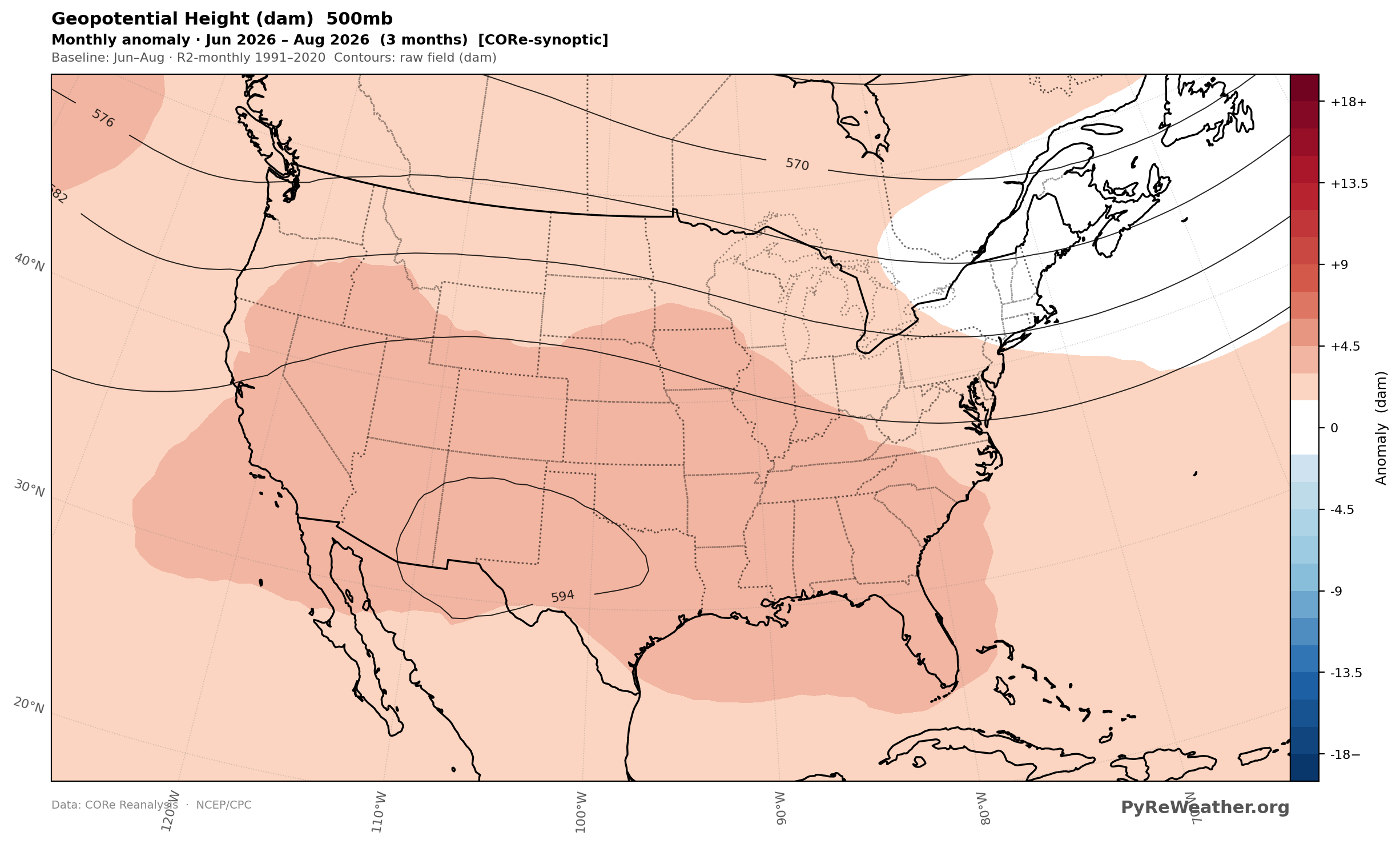
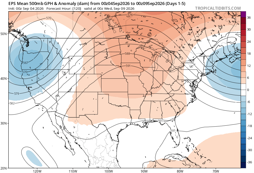
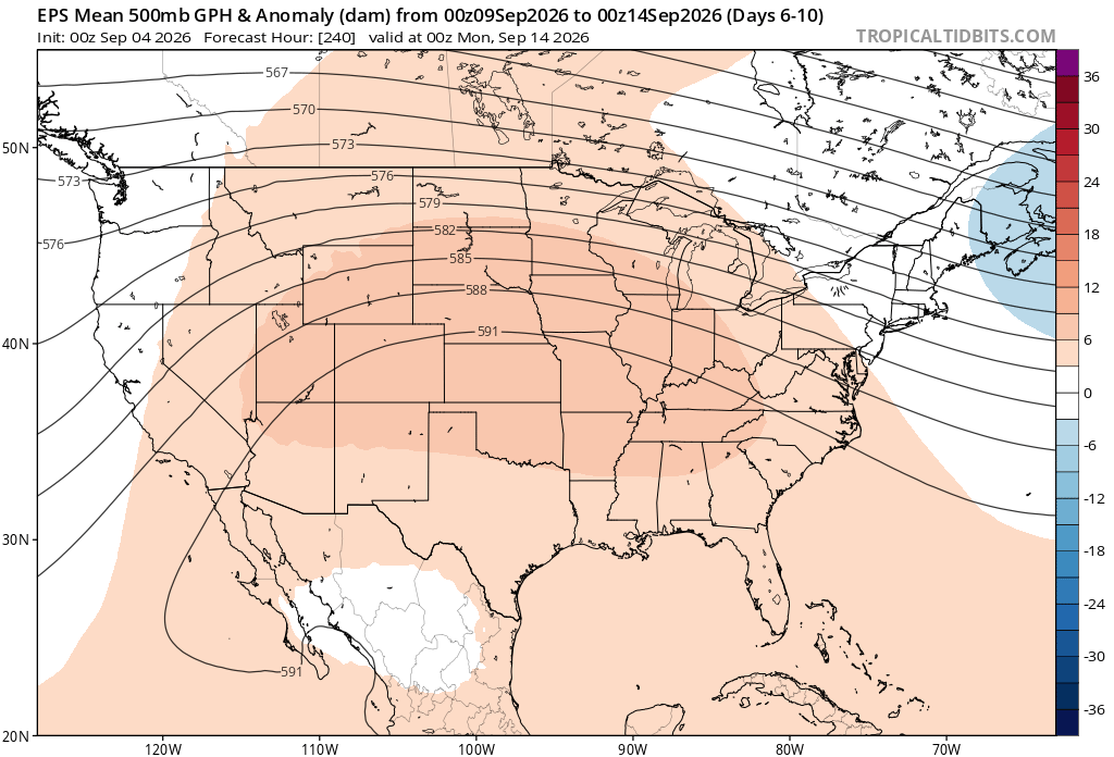
-
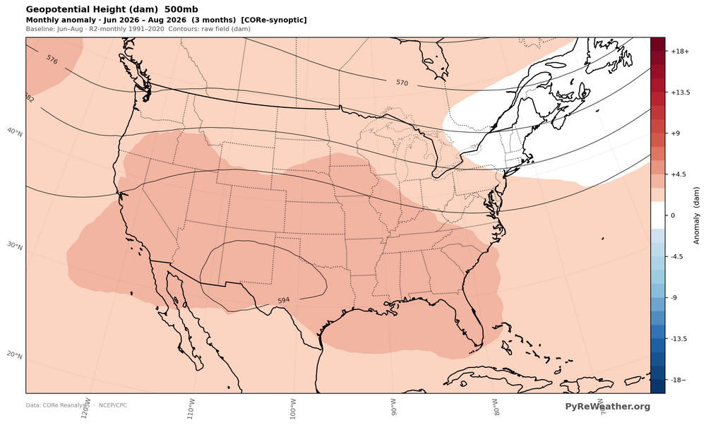
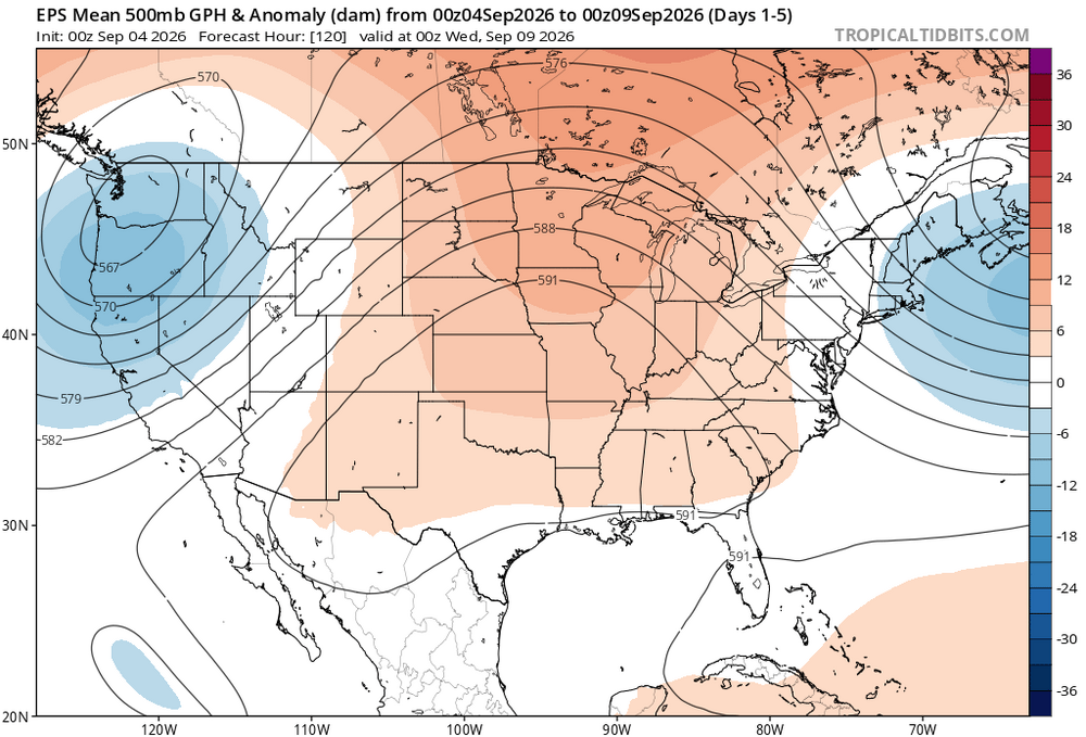
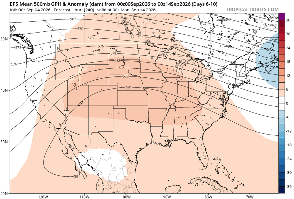
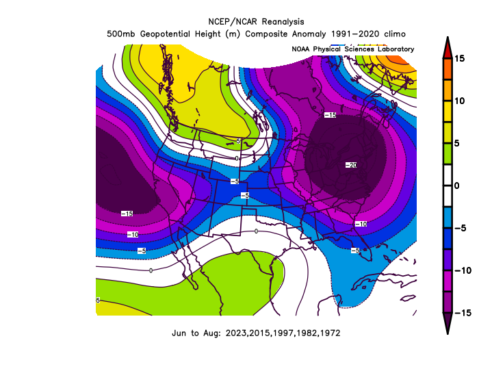
In terms of 95°+ days it was a pretty high ranking for many locations. Areas away from the sea breeze made it to 35 days of 90° and over 40 days at the Philly stations. But this would have been a cooler summer in the past during developing super El Niños. Most summers following super El Niños had more heat than the one while it was still developing like this year. So we would expect more heat than this one during the next few summers. Since the ridge axis this summer was out near 100W, the strongest heat this summer in our region was from Philly to ACY. We have been getting the stalled fronts with too much convection here to have the kind of heat areas just to our south did. The start of September looks like more of the same with the main heat dome staying to our west. Maybe we can get a day or two next week near 90° but it could stay closer to Philly. Have a very happy birthday coming up. You pick the perfect spot at a higher elevation which is cooler than areas just to your south and east. Summer 2026 heat dome centered near 100W Next 10 days look like more of the same Past developing super El Niño summers have been much cooler with more troughs than ridges