All Activity
- Past hour
-
1. For you: How’s the surf in your area? 2. For all: Can a subtropical cyclone attain hurricane force winds but still not be classified as tropical?
-
Phenomenal stretch of days. Hard freeze starts in the 20s and goes to 60F under cloudless skies. It is crazy how this time of year there can still be frost in the shade at like 11am despite it closing in on like 50F outside.
-
Thats all I have is white oaks. The bark is very different from a red oak. They are great for fire wood and floors. Thats about it. They make a mess in the yard.
-
Not a good day. Cloudy and pretty breezy all day. Mid 50s at best. Offshore storm making itself known the last couple of days.
-

2026 Atlantic Hurricane Season
LongBeachSurfFreak replied to Stormchaserchuck1's topic in Tropical Headquarters
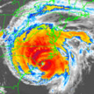
Absolutely. You can see the fronts are gone in Josephine. But the convention is not particularly deep near the center. It also has a relatively large area of tropical storm force winds in the northern quadrant (gradient driven) . -
Severe weather outbreak in progress in central AZ. Could be another huge night in these parts as well. Only had to go 3,000 miles and wait 13 months for severe weather
-
That stupid tie feels worse than any other losses
-
2026 Atlantic Hurricane Season
NorthHillsWx replied to Stormchaserchuck1's topic in Tropical Headquarters
Hope all those weather hypers on social media study this system. This is what a STS looks like. Not that nor Easter last time -
I don't think it's going to be a black and white El Nino event.
- Today
-
I'm curious how it'll do with precipitation amounts, but we'll have to wait a bit for that.
-
Subtropical Storm Josephine Advisory Number 1 NWS National Hurricane Center Miami FL AL102026 500 PM AST Wed Oct 21 2026 ...SUBTROPICAL STORM JOSEPHINE FORMS... ...FORECAST TO MOVE NORTHEASTWARD AWAY FROM THE UNITED STATES... SUMMARY OF 500 PM AST...2100 UTC...INFORMATION ---------------------------------------------- LOCATION...37.4N 69.5W ABOUT 265 MI...425 KM S OF NANTUCKET MASSACHUSETTS ABOUT 585 MI...940 KM SW OF HALIFAX NOVA SCOTIA MAXIMUM SUSTAINED WINDS...65 MPH...100 KM/H PRESENT MOVEMENT...N OR 10 DEGREES AT 6 MPH...9 KM/H MINIMUM CENTRAL PRESSURE...990 MB...29.24 INCHES Subtropical Storm Josephine Discussion Number 1 NWS National Hurricane Center Miami FL AL102026 500 PM AST Wed Oct 21 2026 The non-tropical area of low pressure (Invest AL93) that we have been monitoring this week has acquired enough subtropical characteristics to be considered a subtropical storm. Scatterometer data showed that fronts near the cyclone had dissipated, with a smaller radius-of-maximum wind than yesterday. Additionally moderate-to-deep convection has been organizing near and west of the warm-core center. Thus, advisories have been initiated on a subtropical storm, and 55 kt is shown as the initial intensity based on the scatterometer data. Josephine has been moving slowly northward today as a shortwave ridge passes across the northeastern United States. The storm should accelerate northeastward tomorrow as a mid-latitude trough digs into the Great Lakes and Northeastern United States, taking the system away from the US. By Friday, the low should turn eastward, to the south of Newfoundland. Model guidance is in good agreement on this path, and the new forecast is close to a blend of the global model consensus and the NOAA corrected-consensus aid HCCA. The subtropical storm will likely intensify during the next day or so through a favorable trough interaction while it remains near the north wall of the Gulf Stream. Global models are in good agreement on a band of hurricane-force winds developing tomorrow on the back side of the low as it undergoes extratropical transition. A slow weakening is anticipated by late Friday with the loss of forcing from the trough while the system moves over cold water. The NHC intensity forecast is similar to a blend of the GFS/ECMWF global model solutions. The cyclone should become absorbed in about 4 days within a much larger low over the North Atlantic. Since the coastal wind hazards with this system have been covered for the last several days through non-tropical products issued by local National Weather Service offices, and the system is forecast to move away from the coast, those products will remain in effect until the threat diminishes. FORECAST POSITIONS AND MAX WINDS INIT 21/2100Z 37.4N 69.5W 55 KT 65 MPH...SUBTROPICAL 12H 22/0600Z 38.1N 69.0W 60 KT 70 MPH...SUBTROPICAL 24H 22/1800Z 39.6N 66.2W 65 KT 75 MPH...POST-TROP/EXTRATROP 36H 23/0600Z 41.4N 61.6W 70 KT 80 MPH...POST-TROP/EXTRATROP 48H 23/1800Z 43.3N 56.9W 60 KT 70 MPH...POST-TROP/EXTRATROP 60H 24/0600Z 44.1N 53.5W 50 KT 60 MPH...POST-TROP/EXTRATROP 72H 24/1800Z 44.4N 50.4W 45 KT 50 MPH...POST-TROP/EXTRATROP 96H 25/1800Z 43.5N 37.5W 40 KT 45 MPH...POST-TROP/EXTRATROP 120H 26/1800Z...DISSIPATED
-
Yes. It will be interesting to see how it fares in coming days.
-
We got Josephine
-
 mixing gabapentin and soma: gabapentin for chronic daily headache - therapeutic dose gabapentin pain
-
I’m expecting a record mild winter imby using some farmers almanac type logic. The warmest winter on record in Minneapolis was set in 23/24 while my wife was pregnant with our second child. This winter she is pregnant with our third.
-
I’ve ignored him years ago….
-
Special Tropical Weather Outlook NWS National Hurricane Center Miami FL 340 PM EDT Wed Oct 21 2026 For the North Atlantic...Caribbean Sea and the Gulf of America: Special Outlook issued to raise formation probabilities for AL93 Offshore of the East Coast of the United States (AL93): Updated: Shower and thunderstorm activity has become better organized in association with a storm-force low pressure area located a few hundred miles off the mid-Atlantic United States coast. The system has continued to acquire subtropical characteristics today and has become separated from fronts. If these trends continue, a subtropical storm could form later this afternoon or tonight while it accelerates northeastward. Regardless of the status of the system, high winds, coastal flooding, and dangerous surf are expected along portions of the U.S. East Coast during the next few days. For more information, including hurricane-force extratropical wind warnings, please consult statements and warnings from local National Weather Service offices and the Weather Prediction Center, along with the High Seas Forecasts and the Storm Warnings issued by the National Weather Service. * Formation chance through 48 hours...high...70 percent. * Formation chance through 7 days...high...70 percent. Evidently, this was already declared STS Josephine just a few minutes ago. ———————— 12Z UKMET was still another having run it even though the text technically called it a TS (I don’t think it is capable of distinguishing T from ST): TROPICAL STORM 93L ANALYSED POSITION : 36.7N 69.0W ATCF IDENTIFIER : AL932026 LEAD CENTRAL MAXIMUM WIND VERIFYING TIME TIME POSITION PRESSURE (MB) SPEED (KNOTS) -------------- ---- -------- ------------- ------------- 1200UTC 21.10.2026 0 36.7N 69.0W 995 44 0000UTC 22.10.2026 12 37.5N 69.4W 991 47 1200UTC 22.10.2026 24 38.8N 68.4W 985 49 0000UTC 23.10.2026 36 39.9N 65.1W 984 66 1200UTC 23.10.2026 48 41.4N 59.5W 982 61 0000UTC 24.10.2026 60 43.0N 56.6W 986 51 1200UTC 24.10.2026 72 43.0N 54.8W 990 46 0000UTC 25.10.2026 84 42.8N 51.4W 994 41 1200UTC 25.10.2026 96 41.7N 45.7W 1004 38 0000UTC 26.10.2026 108 CEASED TRACKING
-
buy zithromax online or zithromax online zithromax order online uk http://www.boosterblog.net/vote-146-144.html?adresse=zpacksupply.com&popup=1 zithromax purchase onlineor http://bbs.51pinzhi.cn/home.php?mod=space&uid=8475323 zithromax 250 mg [url=http://clients1.google.bt/url?q=https://zpacksupply.com]purchase zithromax z-pak[/url] buy zithromax canadaor [url=https://brueckrachdorf.de/user/mfmofrsbno/]zithromax online[/url] zithromax z-pak
-

Yellow Medicine County, MN - Climate Fact or Climate Fiction?
Cobalt replied to Cobalt's topic in Climate Change
Sep 2026 data is still yet to come in for Yellow Medicine County, Minnesota (Population 9,477), but the trend from past Septembers indicates that the month is among the fastest warming. Increases in both high and low temperatures are to blame.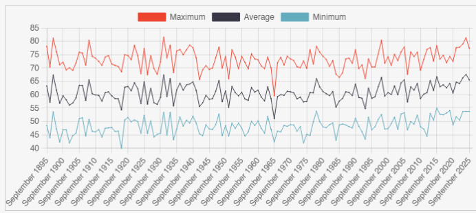
-
ISP hit 59, warmer here at 63
-

E PA/NJ/DE Autumn 2026 Obs/Discussion
ChescoWx replied to PhiEaglesfan712's topic in Philadelphia Region
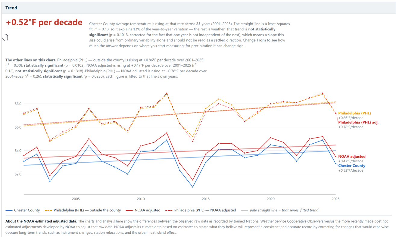
Over the last 25 years, Since 2001 PHL Airport warming is statistically clear in both its raw and NOAA-adjusted records. By comparison here in the nearby philly burbs of Chester County PA our warming is less or about 40% smaller than the PHL heat island. The warming across Chester County has not been statistically significant using either the raw or NCEI adjusted data over the last 25 years! The gap between the two (+0.34°F/decade) is consistent with an urban/airport effect. One more point of interest: NOAA’s data adjustment only trims PHL’s trend slightly (0.86 → 0.78). So, importantly whatever UHI warming that is in the airport record over this window, the homogenization is removing very little of it!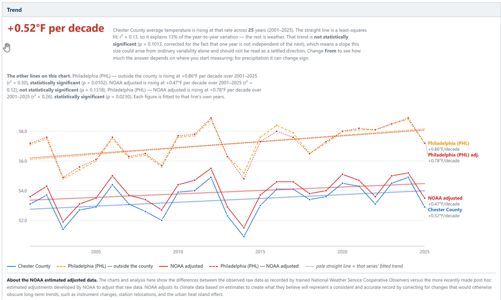
-
don't you just love when the oak leaves blow around on top of snowpack and settle into footprints and snowmobile tracks. ruins a beautiful pack
-
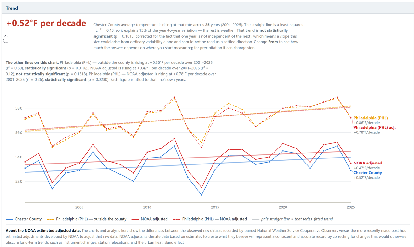
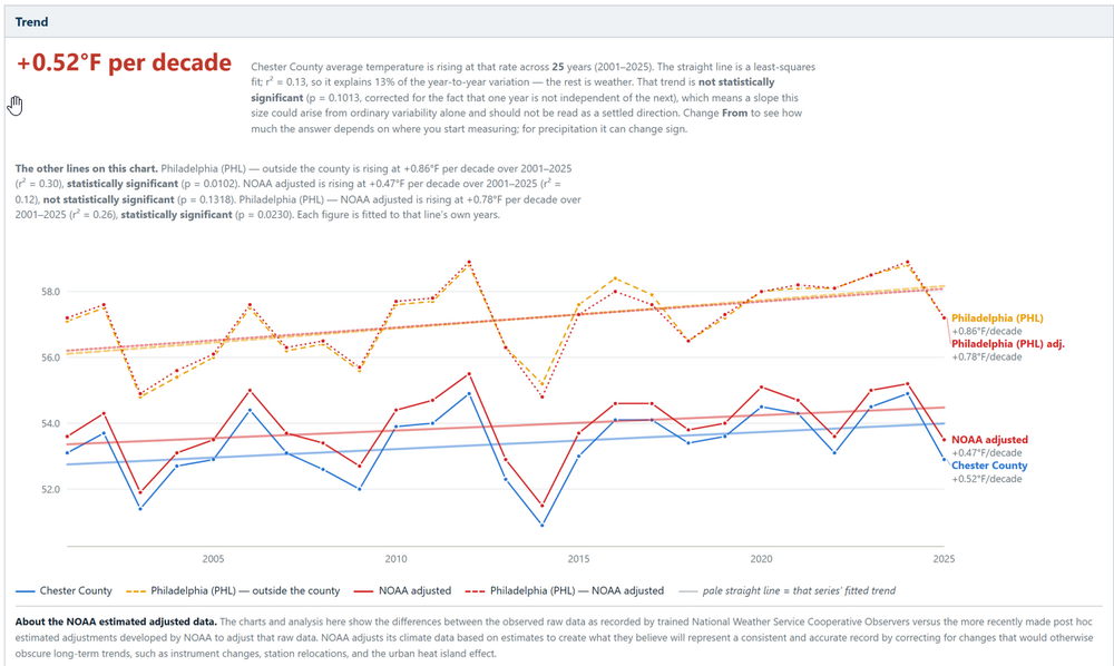
Over the last 25 years, Since 2001 PHL Airports warming is statistically clear in both its raw and NOAA-adjusted records. By comparison Chester County’s warming is about 40% smaller and not statistically significant using either the raw or NCEI adjusted data. The gap between the two (+0.34°F/decade) is consistent with an urban/airport effect. One more point of interest: NOAA’s data adjustment only trims PHL’s trend slightly (0.86 → 0.78). So, importantly whatever UHI warming that is in the airport record over this window, the homogenization is removing very little of it!
-
I'm moving up to Barns Corner, Tug Hill on Dec 1. I'm looking at forward to learning all the different species of trees up there. I know all the trees here in Maryland. I can identify trees by the bark, leaves, and crown shape. While I'm playing in the snow I'll be studying the different trees species. Sorry so the banter. I get excited when fokes talk about trees.
-
Exactly. I pointed this out a couple weeks ago and got weenied for some reason...but it's true! I mean in any winter the prime window always starts around that time anyway.