weatherMA Posted April 6, 2011 Share Posted April 6, 2011 There's a pile at my school from when they roof raked...its massive. It looks about half the size as it was. It's ice packed and at least 10 feet tall. It must have been 20+ feet at the start. Maybe it will last until June? It would be cool for there to still be some snow piles on a 90F day in May. Although by that point it will be more like a dirt pile. Link to comment Share on other sites More sharing options...
moneypitmike Posted April 6, 2011 Share Posted April 6, 2011 Had a gust to 31 half an hour ago. Better than expected--blowing pretty good there still. Link to comment Share on other sites More sharing options...
weatherMA Posted April 6, 2011 Share Posted April 6, 2011 WOW. Whdh bold on the warmth and sun. They say no rain fri/sat then approaching 80 on Monday. Link to comment Share on other sites More sharing options...
ski MRG Posted April 6, 2011 Share Posted April 6, 2011 The last winter pile has melted. Took till 4/5 and it was in the shade. But give us a day in the 60s with high td and rain and the pile is no match. Give it up folks if you're in SNE. It's been over for awhile but now unquestionably. LOL. Link to comment Share on other sites More sharing options...
Logan11 Posted April 6, 2011 Share Posted April 6, 2011 He is probably right for Boston...but not GC. LOL. Link to comment Share on other sites More sharing options...
TalcottWx Posted April 6, 2011 Share Posted April 6, 2011 LOL. Winter is over minus the mtns Link to comment Share on other sites More sharing options...
ski MRG Posted April 6, 2011 Share Posted April 6, 2011 Winter is over minus the mtns Life outside the mountains is not one of my concerns. Link to comment Share on other sites More sharing options...
CoastalWx Posted April 6, 2011 Share Posted April 6, 2011 Life outside the mountains is not one of my concerns. It's over. Drip away. Link to comment Share on other sites More sharing options...
dendrite Posted April 6, 2011 Share Posted April 6, 2011 WOW. Whdh bold on the warmth and sun. They say no rain fri/sat then approaching 80 on Monday. 00z EC has 2m temps in the 80s for the Champlain/Hudson/CT valleys...it'd probably make the Merrimack valley too. 850s reach +16C. Link to comment Share on other sites More sharing options...
CoastalWx Posted April 6, 2011 Share Posted April 6, 2011 00z EC has 2m temps in the 80s for the Champlain/Hudson/CT valleys...it'd probably make the Merrimack valley too. 850s reach +16C. Euro is an inferno. Link to comment Share on other sites More sharing options...
Damage In Tolland Posted April 6, 2011 Share Posted April 6, 2011 Life outside the mountains is not one of my concerns. Big melting incoming..big big melting Link to comment Share on other sites More sharing options...
Damage In Tolland Posted April 6, 2011 Share Posted April 6, 2011 The TORCH is coming !!!! Link to comment Share on other sites More sharing options...
HoarfrostHubb Posted April 6, 2011 Share Posted April 6, 2011 24.2F attm. Torch schmorch. Link to comment Share on other sites More sharing options...
powderfreak Posted April 6, 2011 Share Posted April 6, 2011 Life outside the mountains is not one of my concerns. Woke up to the sound of the plow in my parking lot... thought huh that's funny there was no snow when I went to bed. Sure enough, 2-3" of beautiful January-quality snow blowing and drifting around out there. Up here at the mountain there's 3-4" in the parking lots and groomers are reporting at least 4-6" on the upper 2/3rds of the mountain. Roads throughout town are snowpacked, icy, and have that arctic feel as dry powder sifts and drifts around the road following each car. All the dirty brown snowbanks are gone, replaced by virgin white. Fresh cornices on roof-tops and always fun to watch the snow blow and drift all over the place. I'm going to enjoy this mid-winter feel for as long as it lasts. Everytime I think winter is done, it just snows some more. It really didn't even rain all that much during that storm... have no idea how that turned into a snowfall on the front and a snowfall on the back with some warmth in the middle. Link to comment Share on other sites More sharing options...
moneypitmike Posted April 6, 2011 Share Posted April 6, 2011 The TORCH is coming !!!! Seems like that's a possibiility. My zfp is caling for lower 50's on Saturday and near 60 on Sunday. Will be warm during this weekend's burning session. 30.0/19. Had a peak gust last night of 32mph. Link to comment Share on other sites More sharing options...
Damage In Tolland Posted April 6, 2011 Share Posted April 6, 2011 Seems like that's a possibiility. My zfp is caling for lower 50's on Saturday and near 60 on Sunday. Will be warm during this weekend's burning session. 30.0/19. Had a peak gust last night of 32mph. I'm talking 70's Link to comment Share on other sites More sharing options...
weathafella Posted April 6, 2011 Share Posted April 6, 2011 LOL. What's so funny Mr I'm in AK? Link to comment Share on other sites More sharing options...
weatherMA Posted April 6, 2011 Share Posted April 6, 2011 00z EC has 2m temps in the 80s for the Champlain/Hudson/CT valleys...it'd probably make the Merrimack valley too. 850s reach +16C. damn The TORCH is coming !!!! Joe Will be happy that CTTORCH has arrived. Link to comment Share on other sites More sharing options...
ski MRG Posted April 6, 2011 Share Posted April 6, 2011 What's so funny Mr I'm in AK? How many times you've sworn Winter off. Link to comment Share on other sites More sharing options...
Allenson Posted April 6, 2011 Share Posted April 6, 2011 Winter is over minus the mtns Rollin' here in the hill-country. See NNE thread. Life outside the mountains is not one of my concerns. LOL. We're in the Highlander Regiment. How's AK? My wife is heading there for work at the end of the month. I'm very jealous and can't accompany her. We have some good friends in Anchorage and she's staying with them.... Link to comment Share on other sites More sharing options...
weathafella Posted April 6, 2011 Share Posted April 6, 2011 How many times you've sworn Winter off. It's April 6th in the Boston area. It's gone. Unless you expect a freak snow weeks from now which I would not have any use for. I'm of the mindset that each season in it's time. Any snow under mega totals at this point is not worth losing sleep over. Link to comment Share on other sites More sharing options...
Mr Torchey Posted April 6, 2011 Share Posted April 6, 2011 The TORCH is coming !!!! YES, CTHEAT IS BACK BABY!!!!!!!!!!!!!!!!!!!!!!! IT WILL BE TOUGH TO BE LAST YEARS PERFORMANCE BUT GOOD LUCK :sun: :sun: Link to comment Share on other sites More sharing options...
HoarfrostHubb Posted April 6, 2011 Share Posted April 6, 2011 Might see some flakes overnight mixed in with raindrops... Joe, need you shout? Link to comment Share on other sites More sharing options...
Mr Torchey Posted April 6, 2011 Share Posted April 6, 2011 Might see some flakes overnight mixed in with raindrops... Joe, need you shout? Yes, its a glorious day that the saviour CTHEAT has returned. Off to work sunny 43 Link to comment Share on other sites More sharing options...
HoarfrostHubb Posted April 6, 2011 Share Posted April 6, 2011 Yes, its a glorious day that the saviour CTHEAT has returned. Off to work sunny 43 I like the Rev Kev persona better... 18-24" with lollies to 30" vs torch melting your face off highs near 105F But to each his own. Not a bad day out there. Our town outhouse contest thing broke through yesterday. We are hoping one of my son's friends won since he was pretty close to the correct date/time. Top prize is $2,000.00. Last year it went through on March 13, the year before March 20. Link to comment Share on other sites More sharing options...
Tropopause_Fold Posted April 6, 2011 Share Posted April 6, 2011 Euro is an inferno. yes it is. hopefully the flow can hold W enough to bring that kind of air right to shore. like how the ec is able to resolve 40s on ACK and 80s in C/W MA. Link to comment Share on other sites More sharing options...
Damage In Tolland Posted April 6, 2011 Share Posted April 6, 2011 Hopefully that's ripe with storms on Tuesday..Euro really slowed downthe fropa. Link to comment Share on other sites More sharing options...
CoastalWx Posted April 6, 2011 Share Posted April 6, 2011 yes it is. hopefully the flow can hold W enough to bring that kind of air right to shore. like how the ec is able to resolve 40s on ACK and 80s in C/W MA. Hopefully it's not a junky atmosphere like the GFS shows. I don't think they'll be that much low level garbage as depicted, but that's always the risk. Link to comment Share on other sites More sharing options...
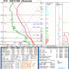
Typhoon Tip Posted April 6, 2011 Share Posted April 6, 2011 Hopefully it's not a junky atmosphere like the GFS shows. I don't think they'll be that much low level garbage as depicted, but that's always the risk. Nice to see the denizens of this fine organization have caught on This multi-day teleconnector flagged warm departure is still on-going. The PNA is negative and pinneed, and the NAO is positive - either could signal a warming pattern; having them both is a converging signal. This is consistent at both the CPC and CDC. However the CPC does have a 2-d fly in the ointment dip in the NAO to nearly neutral, but then rockets it back to over +1SD in the extended. I'm not sure such a brief excursion is enough to orchestrate much of a mass field response at our lat/lon. Not likely... That said, I recall mentioning last week or thereabouts that the deterministic guidance might rather abruptly catch on and begin depicting bigger warming. The recent Euro runs play terrific homage to that. That 144 hour panel (8 pm next Monday evening) from 00z last night is a whopper warm day here in SNE considering we have not really had any seriously warm departed stints, so it may come as a bit of a shocker actually. +17C at 850 mb, with a WSW wind, along with 700mb RH of 50% allows for substantial solar insolation - if the BL gets that tall, and I think it could if that PP verified due to sufficient mixing in a 22kt mid BL flow, we'd make 84F at places like BED and CEF in a snap. Tough to go that bullish with the GFS so cool, but the GFS does have a slight longitudinal bias so it is not surprising that it is... Also, keep in mind folks not to be too MOS reliant in mid spring and mid autumn for your middle and extended ranges. MOS verification is best in mid winter and mid summer, when for a number of weeks climo becomes static. At the transition seasons, the dailies are shifting warm and cooler respectively, and thus climo melded into the MOS products out in time will tend to mute any extremes. 78F is what the Euro has for Monday afternoon at FIT, and that is about 6F underdone balanced against the synoptics of the day off the Euro run and as is. Again, this is notwithstanding whether it actually verifies that way. However, I will add that the Euro has been honing at least one hugely warm departed afternoon during either Monday or Tuesday of this next week, more so than not across recent runs. Personally I'd go with 80F for Monday and word that as possibly even warmer. Seasonal: This is appearing to duplicate last year to some lesser degree - no pun intended. Though we did not register regionally a warm March as we did last year, I do see some similarities going forward in that we are loosing just about all vectors for cold unilaterally in much in the same way. April may very well go down as above, perhaps well above normal. The AO is lofty, meaning that hemispherically the westerlies gradient is relaxing at middle latitudes by day. Combined with a general retreat N by the more middle latitude teleconnectors (PNA/NAO), indicates even perhaps early warm season eruption of subtropicl ridge dominance. This can be seen also in the AAM totals, showing increased torque (or lessening meridional flow); though it is not a prognostic tool, it does give some semblance of where we are going particularly when balancing in these other statistical packages. Interesting... Link to comment Share on other sites More sharing options...
ski MRG Posted April 6, 2011 Share Posted April 6, 2011 Rollin' here in the hill-country. See NNE thread. LOL. We're in the Highlander Regiment. How's AK? My wife is heading there for work at the end of the month. I'm very jealous and can't accompany her. We have some good friends in Anchorage and she's staying with them.... AK is absolutely awesome. I can't even find the words to describe it. As often as I've been here I'm still floored by it's beauty. Link to comment Share on other sites More sharing options...

Recommended Posts
Archived
This topic is now archived and is closed to further replies.