

StormyClearweather
-
Posts
716 -
Joined
-
Last visited
Content Type
Profiles
Blogs
Forums
American Weather
Media Demo
Store
Gallery
Everything posted by StormyClearweather
-
From LWX Disco THE BIGGEST AREA OF FOCUS OF THE THE LONG TERM WILL BE AN AREA OF LOW PRESSURE TRACKING FROM THE MISSISSIPPI RIVER VALLEY TOWARDS NEW ENGLAND, BRINGING WINTRY WEATHER TO THE REGION SUNDAY EVENING THROUGH MONDAY. THERE REMAINS A GOOD BIT OF MODEL DISCREPANCY REGARDING THE TRACK AND TIMING OF THE LOW PRESSURE SYSTEM, THEREFORE LEADING TO UNCERTAINTY WHEN IT COMES TO A SNOWFALL AMOUNT AND PRECIPITATION TYPE FORECAST. WHILE TEMPERATURES AT THE SURFACE ARE EXPECTED TO STAY NEAR OR BELOW FREEZING, MODEL SOUNDINGS INDICATE A PROLONGED WARM NOSE LEADING TO PRECIPITATION TYPE TRANSITIONING FROM SNOW TO SLEET/FREEZING RAIN. THIS WILL LEAD TO LOWER SNOW TOTALS THAN SOME MODELS ARE CURRENTLY INDICATING. 12Z MODEL GUIDANCE IS SHOWING A LIGHT SHIFT NORTH FOR THE LOW PRESSURE SYSTEM, WITH ACCUMULATION AMOUNTS CONTINUING TO SHOW A GOOD BIT OF DISCREPANCY. PRECIPITATION ONSET WILL LIKELY BE SUNDAY AFTERNOON THROUGH SUNDAY NIGHT WITH PRECIPITATION MOVING OUT OF THE AREA EARLY TUESDAY MORNING.
-
Or better yet, expand those pretty pinks. PV version:
-
-
Check out those DPs
-
To me, NAM looks very close to ECMWF at 84, but that's just the surface, which is all I know how to look at.
-

January Medium/Long Range: A snowy January ahead?
StormyClearweather replied to mappy's topic in Mid Atlantic
Except with far lighter QPF. But agree in general. -
January Medium/Long Range: A snowy January ahead?
StormyClearweather replied to mappy's topic in Mid Atlantic
To my untrained eye, ECMWF AI looks wetter for most of us than 12Z (noise-ish level). Low position is roughly the same as 12Z. It shows precipitation breaking out for most at or after 6Z Monday. 12Z -
January: Medium/ Long Range: May the Force be with Us....
StormyClearweather replied to Weather Will's topic in Mid Atlantic
He meant Ji. Also GFS is faster again. -
January: Medium/ Long Range: May the Force be with Us....
StormyClearweather replied to Weather Will's topic in Mid Atlantic
Yep, ICON souther and even faster than the Euro now. -
January: Medium/ Long Range: May the Force be with Us....
StormyClearweather replied to Weather Will's topic in Mid Atlantic
Was just about to post the PW version, with the 24-hour option: -
January: Medium/ Long Range: May the Force be with Us....
StormyClearweather replied to Weather Will's topic in Mid Atlantic
Man that looks sexy. Sped up a bit vs. 6Z, better matching the Euro's timing. -
January: Medium/ Long Range: May the Force be with Us....
StormyClearweather replied to Weather Will's topic in Mid Atlantic
Well CMC is certainly different than 12Z. I make no calls, but maybe good signs so far? -
January: Medium/ Long Range: May the Force be with Us....
StormyClearweather replied to Weather Will's topic in Mid Atlantic
Verbatim, GFS has many of us go below freezing by 3Z on the 7th and stay there through the end of the run (12Z on the 14th). -
A little too progressive for my liking. Wound up at .10 here.
-
Sign me up. (For entertainment purposes only.)
-
Forecast models seem like they'd be one area where AI can make a rapid impact. Curious to see how this evolves: https://www.theverge.com/2024/12/7/24314064/ai-weather-forecast-model-google-deepmind-gencast
-
It's a good thing we know that JB would never stoop to the level of hyping something without substance to boost the subs. Seriously though, I get why people post his takes on here, but do people really still follow and listen to him?
-
11th Annual Mid-Atlantic Snowfall Contest
StormyClearweather replied to RodneyS's topic in Mid Atlantic
BWI: 7.4” DCA: 5.1” IAD: 9.6” RIC: 3.1” Tiebreaker (SBY): 5.9 -
Hurricane Helene: Remnants Impact to Mid-Atlantic
StormyClearweather replied to WxUSAF's topic in Mid Atlantic
Helene now up to Category 4. Going to be a wild night in the south. -
Remnants of PTC8: Drought Denting Rain Event
StormyClearweather replied to Weather Will's topic in Mid Atlantic
Think you might be on to something! GFS is downright painful. You know it's dry when we're starting threads about a little rain. -
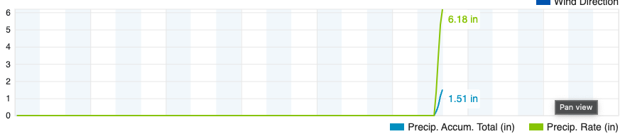
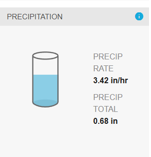
Pretty good storm starting to wind down here. Torrential rain with an hourly rate of 6.18". Looks like we'll land at about 1.7", which is just a little less than I got from Debbie.
-
Tropical Storm Debby: Mid-Atlantic Impacts
StormyClearweather replied to WxWatcher007's topic in Mid Atlantic
FWIW, 0Z HRRR looks pretty significantly east than the 18Z, though still plenty west to keep the folks who really need rain in on the game. -
GFS looks to be holding firm on the southern track, re-landfalling near Savannah Thursday morning and pushing slowly west.
-
Dangerous Situation Warning up for cell in NoVa: Severe Thunderstorm Warning National Weather Service Baltimore MD/Washington DC 502 PM EDT Sat Aug 3 2024 The National Weather Service in Sterling Virginia has issued a * Severe Thunderstorm Warning for... Southwestern Loudoun County in northern Virginia... North central Fauquier County in northern Virginia... Northwestern Prince William County in northern Virginia... * Until 530 PM EDT. * At 500 PM EDT, a severe thunderstorm was located near Delaplane, or 15 miles north of Warrenton, moving east at 40 mph. THIS IS A DESTRUCTIVE STORM FOR DELAPLANE, MIDDLEBURG, AND ALDIE. HAZARD...80 mph wind gusts. SOURCE...Radar indicated. IMPACT...Expect considerable damage to trees and power lines. Your life is at significant risk if outdoors. In addition to some trees falling into homes, wind damage is possible to roofs, sheds, open garages, and mobile homes. * Locations impacted include... Middleburg, Marshall, Saint Louis, Aldie, Halfway, and Rectortown. PRECAUTIONARY/PREPAREDNESS ACTIONS... This is an EXTREMELY DANGEROUS SITUATION. This storm is producing widespread wind damage across Delaplane, Middleburg, and Aldie. SEEK SHELTER NOW inside a sturdy structure and stay away from windows! Large hail, damaging wind, and continuous cloud to ground lightning are occurring with this storm. Move indoors immediately. Lightning is one of nature's leading killers. Remember, if you can hear thunder, you are
-
Wild. I said I'd be happy to get .3 today, so I won't complain, even if the dogs really, really didn't like this: https://video.nest.com/clip/67f945793cee4911bd068a93b2cee8b3.mp4
- 1,696 replies
-
- 2
-

-
- severe
- thunderstorms
- (and 5 more)


