All Activity
- Past hour
-
i appreciate sunny days in january and february, but I would gladly trade those for some sun now.
-
People want to know when the nations of the world will finally start addressing climate change. The answer is when the cost of business as usual gets too high. My guess is that between now and 2040 the damages from climate change to the economy will result in a shift in consciousness about the environment. While we are probably committed to +2C to +3C of warming, I think we can still avoid a PETM +5C to +8C scenario.
-
I like these occasional days especially if I was able to get out and about while it was nice. What’s annoying is the frequency. We had a long duration, gray, overcast period several years back in May. This isn’t like that, but it’s not ideal. I’d rather get our precip via thunderstorms that last 45 mins and are surrounded by mostly sunny conditions.
-

Central Pa. Spring 2024
Itstrainingtime replied to mahantango#1's topic in Upstate New York/Pennsylvania
2 day rainfall total here is just .22" - rained much of the afternoon and a bit more overnight, but nothing at all fell here while the Harrisburg area got the goods last evening. -
Straight outta Dubois.
-
God morning, is there anybody alive out there?! Up to .52" for this event. 2.70" for the month so its looking like another above normal month here. My son got married at Notre Dame on 5/4/24, a fantastic weekend all around! The weather turned out great out there that day. My son and daughter-in-law are doing it again this Sunday in NJ for all friends and family (Notre Dame was a relatively small affair). Hoping the rain gets out of here by Sunday afternoon.
-
Clearfield county quality Sent from my SM-G970U using Tapatalk
-
Talk about mold and germs!
-
How many hookers Sent from my SM-G970U using Tapatalk
-
Patience. Remain vigilant. As EJ said, for as many rainy days as we’ve had, it hasn’t added up to much above normal precip.
-
ETA: I do feel bad for your Saturday event.

-

May 2024 Discussion - Welcome to Severe Season!!!!
Typhoon Tip replied to weatherwiz's topic in New England
Actually the 00z ICON looks like the Euro for the weekend, fwiw. basically, the GGEM/GFS are smudge happy for days. The Euro and ICON are at least dry. It actually wouldn't be a bad thing to get some beneficial rains tomorrow, but it looks like light showers to me. The NAM's 00z/06z trended S ...now just grazing the region with what probably amounts to not completely even wetting the streets type sprinkles. -
I have a pontoon. Let's make a deal.
-
No idea honestly. By all indications it seems I have a deviated septum.
-

Occasional Thoughts on Climate Change
LibertyBell replied to donsutherland1's topic in Climate Change
-
Occasional Thoughts on Climate Change
LibertyBell replied to donsutherland1's topic in Climate Change
what I want to know is why are we getting so much blocking in spring now? -
we might be getting a huge solar flare by then too-- 13 days from now
-
looks like lots of sun and 70s on tap best climo days
-
Low of 31 this morning, cold spot again is Baraga Plains at 22. One more night in the 30's then a bit of unsettled weather and milder. Of the 15 days this month, 10 have been in the 30's at night, the coolest being this morning and the warmest 45 on the 7th. Should be able to start planting in 2 weeks.
-

May 2024 Discussion - Welcome to Severe Season!!!!
powderfreak replied to weatherwiz's topic in New England
We had a min of 57F last night with occasional thunder… all jokes aside, that’s some summer night stuff up this way. Has to be close to a +20 night, ha. -
When was the last time we seen a cutoff low just off coast hang their for a day?
-
May 2024 Discussion - Welcome to Severe Season!!!!
Typhoon Tip replied to weatherwiz's topic in New England
SE zones enjoying a meso-beta scaled sun hole. Surrounded be a rampart of clouds, but looping shows it's holding out. Ha. Can't imagine that's ultimately very sustainable - it's like the General Custard morning -
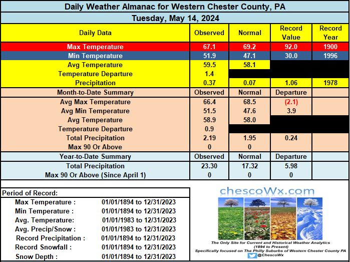
0.58" of rain since yesterday here in East Nantmeal with 0.21" since midnight. Cloudy and chilly weather for May continues through the upcoming weekend with the greatest chances of rain being today and again on Saturday. The sun may should return again by Monday and we should finally see temps rising back to near normal levels again by Tuesday. Chester County records for today: High 95 degrees at Coatesville 1SW (1900) / Low 32 degrees at Devault 1W (1954) / Rain 2.09" at East Nantmeal (2012)
-

E PA/NJ/DE Spring 2024 OBS/Discussion
ChescoWx replied to Hurricane Agnes's topic in Philadelphia Region
0.58" of rain since yesterday here in East Nantmeal with 0.21" since midnight. Cloudy and chilly weather for May continues through the upcoming weekend with the greatest chances of rain being today and again on Saturday. The sun may should return again by Monday and we should finally see temps rising back to near normal levels again by Tuesday. Chester County records for today: High 95 degrees at Coatesville 1SW (1900) / Low 32 degrees at Devault 1W (1954) / Rain 2.09" at East Nantmeal (2012)
-
The record warm winter pattern lingered until around St.Patrick’s day giving us the warmest March 1-17th on record. Then the spring blocking pattern kicked in which has been a dominant feature in recent years. So the average high temperature ranking with all the clouds, rain, and onshore flow dropped down to 22nd place over this period. Time Series Summary for NEWARK LIBERTY INTL AP, NJ Click column heading to sort ascending, click again to sort descending. Rank Ending Date Mean Avg Temperature Mar 1 to Mar 17 Missing Count 1 2024-03-17 51.1 0 2 1973-03-17 50.3 0 3 2016-03-17 49.0 0 4 2012-03-17 48.3 0 5 1977-03-17 48.1 0 6 2020-03-17 47.9 0 7 2000-03-17 47.8 0 8 1946-03-17 46.3 0 9 1990-03-17 46.0 0 10 2010-03-17 45.9 0 Time Series Summary for NEWARK LIBERTY INTL AP, NJ Click column heading to sort ascending, click again to sort descending. Rank Ending Date Mean Max Temperature Mar 18 to May 14 Missing Count 1 2010-05-14 67.8 0 2 1985-05-14 66.5 0 3 2023-05-14 66.3 0 4 2012-05-14 66.1 0 5 1945-05-14 65.9 0 6 2021-05-14 65.3 0 7 1994-05-14 65.2 0 8 1949-05-14 65.1 0 9 1976-05-14 65.0 0 10 1986-05-14 64.7 0 11 2006-05-14 64.2 0 - 1938-05-14 64.2 0 12 1993-05-14 64.0 0 13 1987-05-14 63.8 0 - 1968-05-14 63.8 0 14 1981-05-14 63.6 0 15 1991-05-14 63.5 0 16 1963-05-14 63.4 0 - 1957-05-14 63.4 0 17 2004-05-14 63.3 0 18 2001-05-14 63.2 0 - 1979-05-14 63.2 0 19 2000-05-14 63.1 0 - 1969-05-14 63.1 0 - 1946-05-14 63.1 0 20 2015-05-14 63.0 0 - 1999-05-14 63.0 0 - 1942-05-14 63.0 0 21 1959-05-14 62.9 0 22 2024-05-14 62.8 0


