All Activity
- Past hour
-
-

May 2024 Discussion - Welcome to Severe Season!!!!
RUNNAWAYICEBERG replied to weatherwiz's topic in New England
Your Canadian ain’t good either. -

Central Pa. Spring 2024
Itstrainingtime replied to mahantango#1's topic in Upstate New York/Pennsylvania
Tornadoes and not even a MRGL from SPC. -
Yeah and my expectations of a another dud is looking more like the usual reality... Will see later 2nght if any legit rain occurs...
-

14th Lawn and Garden Thread P Allen Smith 2024
Brewbeer replied to Damage In Tolland's topic in New England
Just mowed for the second time (before tomorrow's misery mist) and I can confirm: lawn does not look as good as it did after the first mow -

May 2024 Discussion - Welcome to Severe Season!!!!
Typhoon Tip replied to weatherwiz's topic in New England
Interesting little short term battle between the this new 18z GFS vs everything else for SNE for tomorrow. GFS is gray but dry...probably a little milder by virtue of being so. Perhaps a little drizzle on the immediate shore points. Maybe some breaks in ceiling out CT and western MA. everything else squares the day into the dumpster with steady light rain shut in weather. -

May 2024 Discussion - Welcome to Severe Season!!!!
Damage In Tolland replied to weatherwiz's topic in New England
EPS has nothing of the sort . Ease back -

Texas 2024 Discussion/Observations
Ed, snow and hurricane fan replied to Stx_Thunder's topic in Central/Western States
My palm survived. NWS reporting just one tornado, near Cypress, preliminary EF-1. Cypress is where the big transmission lines (the reason 600,000 in the county are still in the dark are), I would have though EF-2 damage to take down transmission towers. https://x.com/TexasMoran/status/1791588419132617007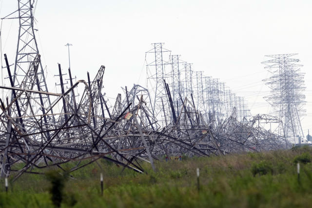
-

Pittsburgh/Western PA Spring 2024
TheClimateChanger replied to Ahoff's topic in Upstate New York/Pennsylvania
https://twitter.com/nwspittsburgh/status/1791577628924912053?s=46 -
Records: Highs: EWR: 94 (1974) NYC: 92 (1974) LGA: 94 (2017) JFK: 89 (1974) LOWs: EWR: 39 (1956) NYC: 39 (1956) LGA: 38 (1983) JFK: 42 (1983) Historical: 1825 - A tornado (said to have crossed all of the state of Ohio) smashed into the log cabin settlement of Burlington, northeast of Columbus. (David Ludlum) 1896: An estimated F5 tornado tracked 100 miles through northeastern Kansas and extreme southeastern Nebraska. Seneca, Oneida, Sabetha, and Reserve, Kansas sustained severe damage. While passing through Reserve, the tornado was 2 miles wide. 25 people were killed, and 200 were injured. The cost was estimated at $400,000. 1960 - Salt Lake City UT received an inch of snow. It marked their latest measurable snowfall of record. (The Weather Channel) 1979: A reading of 12 degrees at Mauna Kea Observatory established a record low for the state of Hawaii. 1980 - Mount Saint Helens (in Washington State) erupted spewing ash and smoke sixty-three thousand feet into the air. Heavy ash covered the ground to the immediate northwest, and small particles were carried to the Atlantic coast. (David Ludlum) 1987 - Thunderstorms in Kansas, developing along a cold front, spawned tornadoes at Emporia and Toledo, produced wind gusts to 65 mph at Fort Scott, and produced golf ball size hail in the Kansas City area. Unseasonably hot weather prevailed ahead of the cold front. Pomona NJ reported a record high of 93 degrees, and Altus, OK, hit 100 degrees. (The National Weather Summary) (Storm Data) 1988 - Low pressure anchored over eastern Virginia kept showers and thunderstorms over the Middle Atlantic Coast Region. Flash flooding was reported in Pennsylvania. Up to five inches of rain drenched Franklin County PA in 24 hours. (The National Weather Summary) 1989 - Thunderstorms developing ahead of a cold front produced severe weather from the Central Gulf Coast States to the Lower Missouri Valley during the day and evening. Thunderstorms spawned sixteen tornadoes, and there were 74 reports of large hail and damaging winds. (The National Weather Summary) (Storm Data) 1990 - Thunderstorms produced severe weather in the central U.S. spawning a sixteen tornadoes, including a dozen in Nebraska. Thunderstorms also produced hail four inches in diameter at Perryton TX, wind gusts to 84 mph at Ellis KS, and high winds which caused nearly two million dollars damage at Sutherland NE. Thunderstorms deluged Sioux City IA with up to eight inches of rain, resulting in a record flood crest on Perry Creek and at least 4.5 million dollars damage. (The National Weather Summary) (Storm Data)
-
May 2024 Discussion - Welcome to Severe Season!!!!
RUNNAWAYICEBERG replied to weatherwiz's topic in New England
Yes. Name me one sane person who wants two rainers like the euro depicts... -
Some of our recent weather reminds me of Summer in UK. I was there for two weeks in early August last year and I loved it. There was quite a bit of sun mixed in with cloudy damp days, but the warmest was a few days in the mid 70s. Best part is I was able to delete 2 weeks of experiencing protracted heat and humidity by not being here lol. It was gross returning to Philly and sweating on the shuttle from the Airport to the parking spot.
- Today
-
We have relatives coming in from south FL tomorrow. They are gonna feel like they've landed in Scotland LOL Can't believe tomorrow, MAY 18, will be the fourth straight Saturday of rain and highs in the 50s
-
https://x.com/mryannagy/status/1791577134571372567?s=46&t=nIoI0c7NSX6uBBZqtNsThg . Near Pittsburgh.
-
Flash Flood Warning for Allegheny County Issued by National Weather Service Pittsburgh, PA 5:17 PM EDT Fri, May 17, 2024 The National Weather Service in Pittsburgh has issued a * Flash Flood Warning for... Central Allegheny County in southwestern Pennsylvania... * Until 815 PM EDT. * At 517 PM EDT, Doppler radar indicated thunderstorms producing heavy rain across the warned area. Between 1 and 2 inches of rain have fallen. Additional rainfall amounts of 0.1 to 0.5 inches are possible in the warned area. Flash flooding is ongoing or expected to begin shortly. HAZARD...Flash flooding caused by thunderstorms. SOURCE...Radar indicated. IMPACT...Flash flooding of small creeks and streams, urban areas, highways, streets and underpasses as well as other poor drainage and low-lying areas. * Some locations that will experience flash flooding include... Pittsburgh, Penn Hills, Mount Lebanon, Bethel Park, Monroeville, McKeesport, Plum, West Mifflin, North Side Pittsburgh, Baldwin, Upper St. Clair, Scott Township, Wilkinsburg, Whitehall, South Park Township, Robinson Township, Munhall, Jefferson Hills, North Versailles and Brentwood. PRECAUTIONARY/PREPAREDNESS ACTIONS... Turn around, don't drown when encountering flooded roads. Most flood deaths occur in vehicles. && FLASH FLOOD...RADAR INDICATED
-

May 2024 Discussion - Welcome to Severe Season!!!!
Torch Tiger replied to weatherwiz's topic in New England
Everyone -
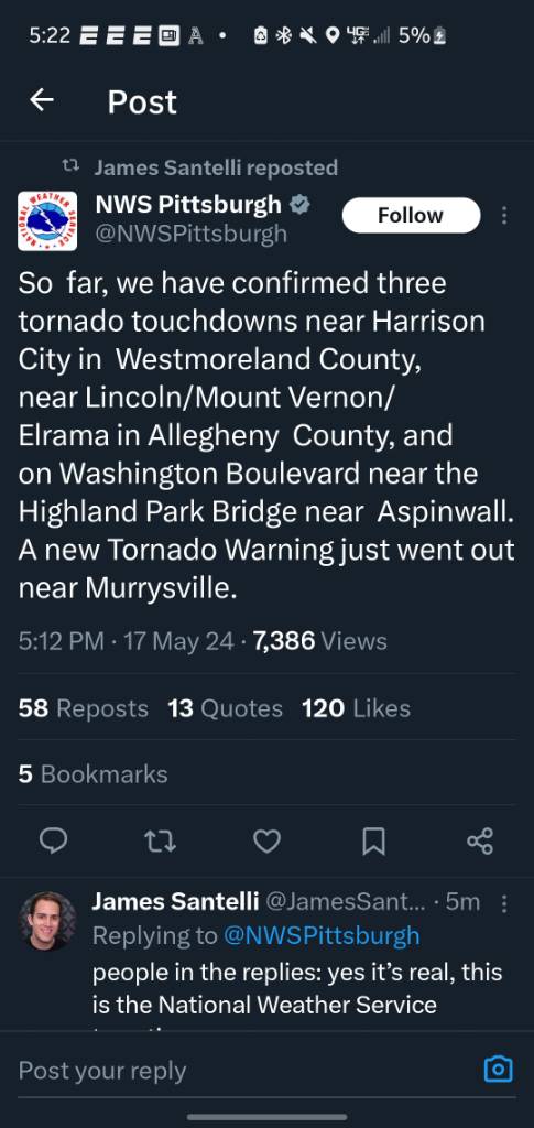
Pittsburgh 3 confirmed tornadoes Sent from my SM-G970U using Tapatalk
-
A partly to mostly cloudy weekend lies ahead. Sunshine will likely increase on Sunday. A few scattered showers are still possible during the weekend. Temperatures should reach the upper 60s to lower 70s tomorrow and lower to middle 70s across the region on Sunday. No significant early-season heat is likely through at least the first three weeks of May. However, it will likely turn warmer next week as sunshine returns. The ENSO Region 1+2 anomaly was -0.4°C and the Region 3.4 anomaly was +0.3°C for the week centered around May 8. For the past six weeks, the ENSO Region 1+2 anomaly has averaged -0.08°C and the ENSO Region 3.4 anomaly has averaged +0.73°C. Neutral conditions are now developing. The SOI was -1.67 today. The preliminary Arctic Oscillation (AO) was -0.023 today. Based on sensitivity analysis applied to the latest guidance, there is an implied 62% probability that New York City will have a warmer than normal May (1991-2020 normal). May will likely finish with a mean temperature near 63.7° (0.5° above normal).
-
Low to mid 70s after that. .
-
And the summer before
-
May 2024 Discussion - Welcome to Severe Season!!!!
RUNNAWAYICEBERG replied to weatherwiz's topic in New England
Everyone is praying the gfs is right with a full coc MDW. -
Tornado Warning for Allegheny County Issued by National Weather Service Pittsburgh, PA 4:40 PM EDT Fri, May 17, 2024 The National Weather Service in Pittsburgh has issued a * Tornado Warning for... East central Allegheny County in southwestern Pennsylvania... Northwestern Westmoreland County in southwestern Pennsylvania... * Until 515 PM EDT. * At 440 PM EDT, a severe thunderstorm capable of producing a tornado was located over Aspinwall, or near Penn Hills, moving east at 15 mph. HAZARD...Tornado. SOURCE...Radar indicated rotation. IMPACT...Flying debris will be dangerous to those caught without shelter. Mobile homes will be damaged or destroyed. Damage to roofs, windows, and vehicles will occur. Tree damage is likely. * This dangerous storm will be near... Penn Hills, Plum, O'hara Township, Oakmont, Fox Chapel, Aspinwall, Verona, and Blawnox around 445 PM EDT. Springdale around 450 PM EDT. New Kensington and Lower Burrell around 500 PM EDT. Arnold around 505 PM EDT. Other locations impacted by this tornadic thunderstorm include Cheswick. PRECAUTIONARY/PREPAREDNESS ACTIONS... TAKE COVER NOW! Move to a basement or an interior room on the lowest floor of a sturdy building. Avoid windows. If you are outdoors, in a mobile home, or in a vehicle, move to the closest substantial shelter and protect yourself from flying debris. Please report severe weather by calling 412-262-1988, posting to the NWS Pittsburgh Facebook page, or using Twitter @NWSPITTSBURGH. && TORNADO...RADAR INDICATED; MAX HAIL SIZE...0.00 IN
-
When the Watch was issued this morning, I flashed it in my newsletter with an advisory that the blend had diminished overnight from 1.02" down to .86" thru 00z 11-20. Who is correct at this hour, the models or the mets. at Sterling???? No contest.......... But 2 am has not arrived.............
-

May 2024 Discussion - Welcome to Severe Season!!!!
tamarack replied to weatherwiz's topic in New England
A few days checking out the buffet, then a week or so of casual dining (the current situation here) followed by a week plus of diving in teeth first - no wandering around looking for a soft spot, just eat and run. Sugar maple leaves about 3/4 grown, red oak halfway, ash and basswood lagging behind as always. -
Using central park as your argument... lmaooo