All Activity
- Past hour
-
We had enough snow, and outside of that heat burst last week, it's not like we've been torching. Next week still looks chilly. Stuck at 27 currently.
-
 Again basically nothing here that shows a moderate risk. A couple tree limbs down ain’t no widespread outbreak. It was an enhanced day maybe DC ne to NJ that’s it.
-
It was not a moderate risk by any definition. Just cause there was a lot of small wind reports does not a moderate make. You need 75+mph wind reports and ef2+ tornadoes. Again moderate risk are rare and what we had the other day happens regularly around here. If that was a moderate risk how was this day a slight risk down south?
-
Both of my game cams reported 8F at 7am in bittinger. 3k ft.
-
we really couldn't have done better that past 3 months than we did. think about 22/23, 23/24, and 24/25 and this winter really made up for that crap. I'm thankful we had that at least. now we can all feel the sun again:)
-
Very interesting. I didn't think to look at the system output for our rooftop in DC. Either the weather is getting shittier every year since 2022, the sun is dying, or my panels are aging.
-

E PA/NJ/DE Spring 2026 Obs/Discussion
LVblizzard replied to PhiEaglesfan712's topic in Philadelphia Region
Looks like we could warm up on Saturday and Sunday, depending on the timing of the warm/cold fronts. The most aggressive models get highs into the 70s on Sunday. Ensembles are much less enthused with highs in the 50s. -
doing my impersonation of the mamas and the papas nyc dreaming on such a winter's day.
-
I'll take another 2002 severe season
-
What’s our snow tally at?
-
But the best effing spring in God’s country. .
-
Tough without any arctic blocking however...
-
Ideal for spring break .
-
I hadn’t really noticed it until I was watching TWC this morning and saw their model blend for the upcoming days, but it looks like there’s a bit of a bread and butter pattern setting up for the coming week, with 3 potential winter systems through the weekend, and 4 over the course of the next week. Modeling shows a system tomorrow night, one Friday night, another Sunday into Monday, and then another on Wednesday. Nothing jumps out immediately as having the potential of the one we had over the weekend, but the recent GFS depictions of the Sunday/Monday system would certainly be in that ballpark. None of the other models really have that setup, and temperatures would potentially be an issue depending on the track, but the GFS is typically pretty good with these patterns, so it’s certainly something to watch. The BTV NWS forecast discussion doesn’t highlight anything too notable at this point, and they mention the potential for warmer temperatures, but they definitely talk about the pattern setting up. We haven’t really seen a Northern Greens bread and butter pattern in a few weeks, so it’s good to see a possible return. It’s definitely worth watching to see if any of the systems or the cumulative accumulations set up any decent or partial resurfacing for the slopes like we saw this past Sunday. Area Forecast Discussion National Weather Service Burlington VT 706 AM EDT Wed Mar 18, 2026 A series of fast moving systems are favored Saturday into Sunday and again later next week as mid/upper level flow goes more near zonal in the base of a long wave trough.

-
Only 25 last night with some clouds keeping it from dropping to 20.
-
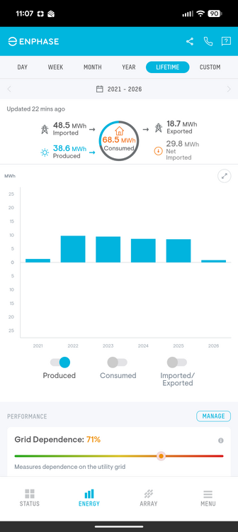
Sample size of one, but for my solar array: 12/20/25 - 3/17/26: 1.2 MWh of power produced 12/20/24 - 3/17/25: 1.4 MWh of power produced 12/20/23 - 3/17/24: 1.4 MWh of power produced So, call it a ~15% reduction in power produced due to cloudiness and snow cover between last winter and this winter (and the winter before that too). Feels worse than that though.
-
It looks like an early final warming this year, yes
-
extended looks dry across nearly the whole country, severe season will be off to a slow start, blessed for our recent rains/action because the zzzzzs are back
-
-
 Hello fellow Philly Dilly. Grew up in Roxborough in the 90s.
 -
I think it was May 02. The shit winter bookended by early and late season events.
-

Occasional Thoughts on Climate Change
donsutherland1 replied to donsutherland1's topic in Climate Change
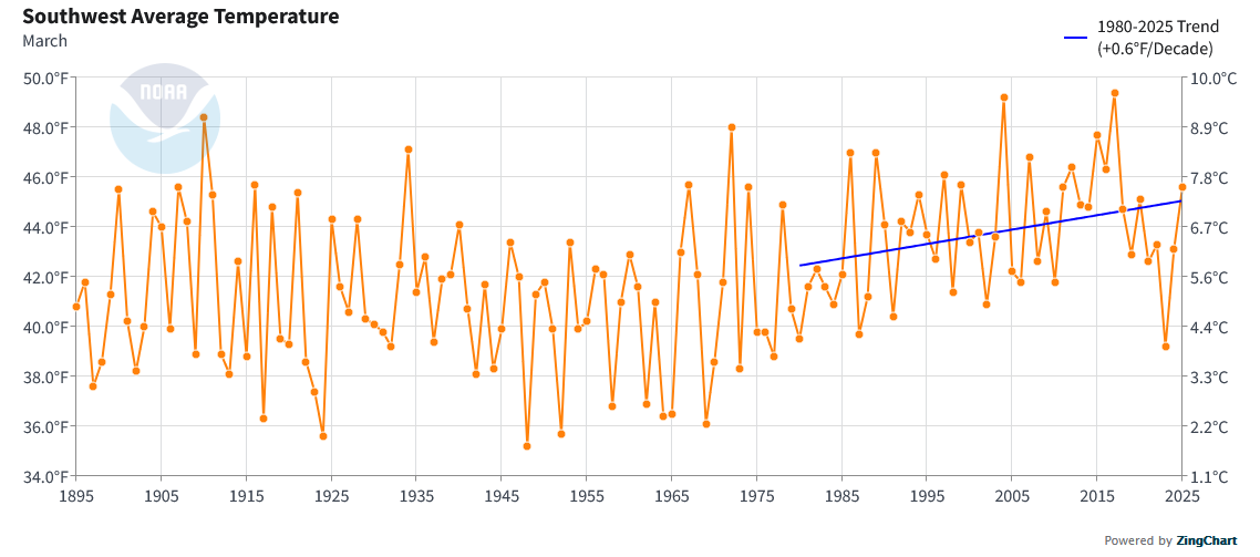
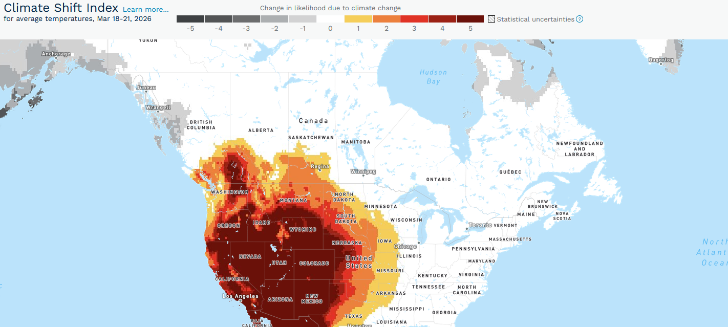
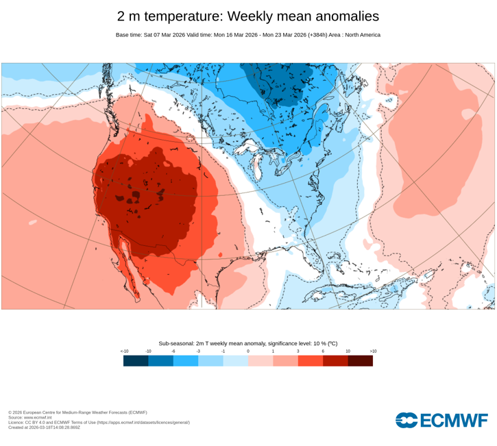
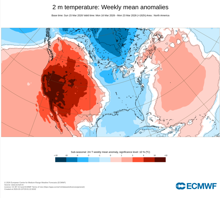
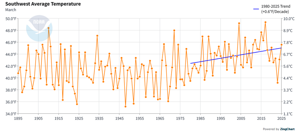
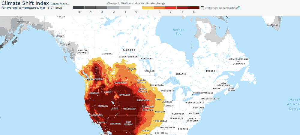
The long-advertised historic March heatwave is now gathering force in the Southwest. Already, monthly high temperature records have fallen in Burbank, Camarillo, and Thermal. Monthly marks were tied in Flagstaff and San Francisco. Downtown Los Angeles missed its longstanding monthly record from 1879 by 1°. Although Palm Springs missed its monthly record by 1° yesterday, it demolished its monthly warmest minimum temperature record by 5° with a low of 75° (a level not seen previously until April 21st). Following the conclusion of a winter that was the warmest on record for many parts of the region, the signature for a possible heat event appeared far in advance. ECMWF Weeklies: March 1: The guidance remained persistence and moved toward an extreme event as the lead time shortened. ECMWF Weeklies: March 7: The final ECMWF weekly forecast from March 15 showed a record-breaking event was imminent. ECMWF Weeklies: March 15: Despite the attention high-profile urban areas receive, the entire region has been warming. Southwest (1980-2025): Warming can produce a non-linear increase in the frequency and severity of heat events, including outside of summer. The March 2012 and September-October 2024 heat events are examples. Climate Central has estimated that climate change has made the forecast event for the Southwest/West at least 5 times more likely in much of those regions. One can expect an avalanche of monthly records over the coming days. Some records could reach or exceed April monthly marks.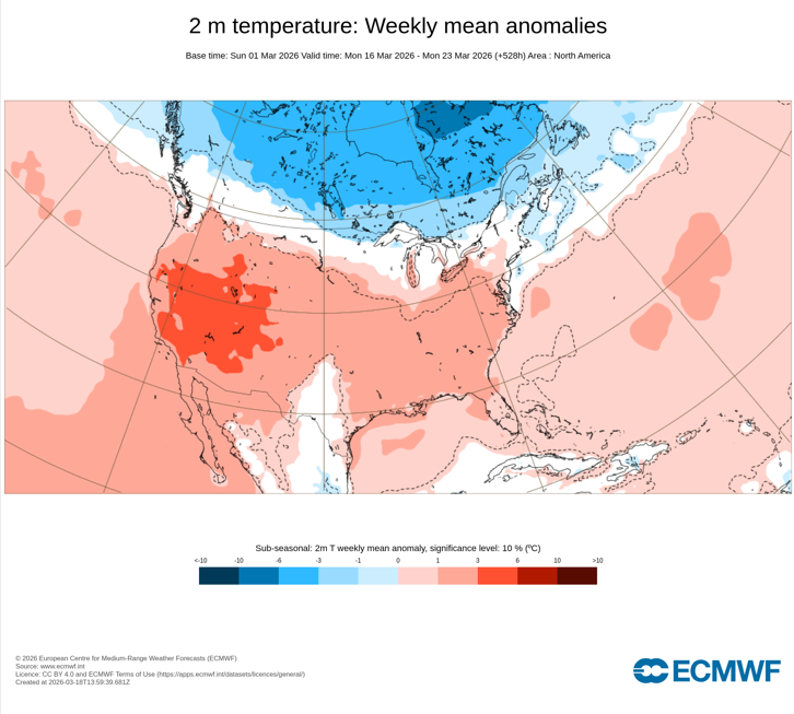
- Today
-
 That's in the past as far as I'm concerned. i just wanna talk weather. If they ever have OT again, I don't want to be a part of it and I won't be allowed anyway lol. Philly is for a number of reasons - but mostly family. I have a ton of family there. And I'm from there.
 -
wondering if this is ewr's record wind gust from the south
-
yes by doing that it almost guarantees more snow by early April - this type of pattern with one colder than normal outbreak after another through early April increases the chances IMO.