All Activity
- Past hour
-
Technically NO, only 3 yrs since the pre-Christmas bomb. You know, the one that was forecast to bomb much earlier and actually be a legit bliz for The Mitt. Instead it finally got going good up in Canada and serious wind-driven +SN was confined to the usual LES Belts of both peninsulas. LP is way over-due for a wound-up powerhouse storm, to say nothing of a CAT-5 (20+) storm that's more than a couple counties.
-
stormy is in quite a stormy mood
-

December 2025 regional war/obs/disco thread
VivaManchVegas replied to Torch Tiger's topic in New England
This was a weather station less than a mile away from me but +500 feet.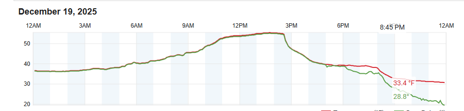
-
Yeah that's the flaw with the ignore feature. Sorry!
-
Looks pretty significant to me but not much talk on here, going to cancel the kids ski lessons on Monday
-

Wounded Duck Strikes Back: Dec 26 & 27th Winter Storm Obs
vortex95 replied to WxWatcher007's topic in New England
Saw 3 reports from Weymouth -- 4.2, 3.5, and 3.3. Which one was CoastalWx? Overall, a quite good event for Dec, esp. CT/RI/SE MA where ocean temps often are a big issue this early. Many locations now have above avg snowfall for Dec. Couple that w/ the solid snowfall in NNE, best winter month for the region in some time! So I don't want to hear it fro CoastalWx! -
Gefs 18z a bit better than 12z, more like 06z
-
I dont see it unless ya'll quote it.....Just saying.
-
Weird dude
-
He cant help himself lol.
-
CAPE is one of the best posters here and you disparage him over nothing. take a break lol
-
Yes this year we've not had any sweet spot tracks. Just accumulated the nickel and dime like a boss per usual. Im antsy for a good 6"+ storm. BTW when did Toronto get 2? Its harder to look up their data since they're Canada. I remember they had 1 within the last few years after some unusually low winters...mother nature always evens it out...I gave the warning years ago that we were gonna pay for our above avg snow seasons here....and I feel we've done that so time to turn it back around.
-
December 2025 regional war/obs/disco thread
VivaManchVegas replied to Torch Tiger's topic in New England
Our temps held out much longer than forecasted on the 19th. It was a good 3 or 4 hours longer than forecasted by the local mets. Where I live, its in a valley with 500 plus foot elevation change just to my north (within a mile). I took a drive up over the hills after that storm and they had lost all of the snow, while we kept a covering in the open areas. This should be an interesting storm.
-
It wasn't a question....................................................dumbass
-
Yeah. But its also about climate. The east coast gets way more big dogs but way less snowstorms overall. Completely different climates. I too wish white lake had longer records
-

Mid-Long Range Discussion 2026
WinstonSalemArlington replied to BooneWX's topic in Southeastern States
-
Wounded Duck Strikes Back: Dec 26 & 27th Winter Storm Obs
vortex95 replied to WxWatcher007's topic in New England
I looked further after you mentioned the dry slot. Now this is whacked. While the sfc low was just E of the Delmarva, the center of the 700 low was close to KRUT! What? So wait, the sfc low by conventional standards is too far S for a SNE hit, yet the 700 low is well N which reeks of big dry slot and pcpn flip. So we ended up w/ the "CoastalWx Quandary," We were fighting dry Arctic air mass at low-levels and at the same time loss of RH at mid and upper levels is moving in? Lose both ways? A squeeze play, dry air storm! And a surprise wild SNOINCR event in CT. Once again, the weirdness of this storm sticks out. - Yesterday
-
Don't know if I trust ensembles or not...but the Euro AIFS ensemble and GEFS at 18z make a lot of sense, though different on several levels. The 18z Euro deterministic AIFS actually ends up w/ a strong EPO/PNA ridge with split flow. Maybe that is where this is headed. If so, Canada would restock w/ very cold air in days, and set the stage for Cosgrove's last third of January to be frigid. Those seeds seem to be in place in LR modeling. I think we have chances prior to that, but just commenting for Jan 15-31st. Either way, it looks some HUGE back and forth cold/warm swings could be in play....I still kind of think Jan 2 is being under modeled in regards to cold. I will try to update one more time as ensembles finish running....with individual members in an effort to sift through this.
-
VivaManchVegas changed their profile photo
-
What lake is the source of the squall in West Virginia? They’ve never experienced this phenomena you speak of, so do explain.
-
why don't you read the Upton AFD I attached ??- also snow squalls from the lakes don't usually reach into south jersey and beyond - glad you have this all figured out already...
-

December 2025 regional war/obs/disco thread
weatherwiz replied to Torch Tiger's topic in New England
Heck of a storm for the Great Lakes region with it -
There have been countless great patterns in the long range over the last few years that looked great only to disappear as the time drew closer. Count me in with the I will believe it when I see it crowd.
-
Pretty wild ski conditions in Japan.
-
Happy hour GEFS is closer to 12z eps look around D10
-
Oof. Well there is always…got nothing


