All Activity
- Past hour
-

INVEST 98L - Possible TD before inland later today
Wannabehippie replied to BarryStantonGBP's topic in Tropical Headquarters
98L still looks like it is having trouble closing off that center of circulation. Even if it doesn't, there is going to be some pretty heavy rains coming onshore. -

Hurricane Erin - 75 mph - 996 mb - WNW @ 18
WxWatcher007 replied to BarryStantonGBP's topic in Tropical Headquarters
Forecast to be 120kt in 72 hours, so this should take off once it can shake off possible dry air entrainment. Hurricane Erin Discussion Number 17 NWS National Hurricane Center Miami FL AL052025 1100 AM AST Fri Aug 15 2025 Erin has become better organized during the past several hours. The last few NOAA and Air Force Reserve aircraft passes through the cyclone have indicated the formation of an eyewall, with the Air Force Reserve aircraft reporting 700-mb flight-level winds of 75 kt northeast of the center. In addition, conventional satellite imagery shows the development of a central dense overcast, and a recently received WSFM microwave overpass shows a well-defined ring of shallow to moderate convection in the 37 GHz imagery. Based on these data, the initial intensity is increased to 65 kt and Erin becomes the first hurricane of the 2025 Atlantic Hurricane Season. The initial motion is 290/15. The subtropical ridge to the north will continue to steer Erin west-northwestward into the weekend. Encroaching mid-latitude westerly flow is forecast to cause a weakness to develop in the ridge during the latter part of the forecast period, and this will result in the hurricane gradually turning northwestward and northward by 120 h. The guidance remains in fairly good agreement through about 60-72 hours. After that time, there are some differences in both the forward speed and cross-track spread with the turn toward the north. The regional hurricane models again lie along the western edge of the guidance envelope, while the GFS and Google DeepMind models remain on the eastern edge. Although still spread, the guidance envelope has not shifted significantly since the last advisory, and the new track forecast is an update of the previous forecast. There is still uncertainty about what impacts Erin may bring to portions of the Bahamas, the east coast of the United States, and Bermuda in the long range. Erin is currently in a favorable environment for strengthening, although there are some uncertainties on whether dry air is entraining into the core. The improved low-level structure indicates potential for rapid strengthening, and based on this the first 36-48 h of the new intensity forecast shows a faster development rate. After 48 h, the hurricane is forecast to encounter some northerly to northwesterly vertical shear that should at least slow development. However, the global and regional hurricane models are in good agreement that Erin will become a powerful and increasingly large hurricane over the southwestern Atlantic over the weekend and into next week. It should be noted that the the Florida State SuperEnsemble and the US Navy COAMPS-TC models forecast higher peak intensities than the official forecast, so it would not be too surprising if Erin became stronger than currently forecast. KEY MESSAGES: 1. Heavy rainfall tonight through Sunday across the northern Leeward Islands, the Virgin Islands, and Puerto Rico may lead to isolated and locally considerable flash and urban flooding, along with landslides or mudslides. 2. Tropical storm conditions are possible for portions of the northern Leeward Islands, where Tropical Storm Watches are in effect, beginning on Saturday as the core of Erin passes north of those islands. Gusts to tropical storm force are possible in rainbands over portions of the Virgin Islands and Puerto Rico later in the weekend. 3. While the threat of direct impacts in the Bahamas and along the east coast of the United States appears to be gradually decreasing, there will still be a significant risk of dangerous surf and rip currents along western Atlantic beaches next week. 4. Interests in Bermuda should continue to monitor the progress of Erin since there is still a risk of strong winds, heavy rainfall, and high surf by the middle part of next week. FORECAST POSITIONS AND MAX WINDS INIT 15/1500Z 18.2N 56.1W 65 KT 75 MPH 12H 16/0000Z 18.9N 58.4W 75 KT 85 MPH 24H 16/1200Z 19.8N 61.4W 90 KT 105 MPH 36H 17/0000Z 20.6N 63.8W 105 KT 120 MPH 48H 17/1200Z 21.6N 66.0W 110 KT 125 MPH 60H 18/0000Z 22.7N 67.9W 115 KT 130 MPH 72H 18/1200Z 23.8N 69.2W 120 KT 140 MPH 96H 19/1200Z 26.5N 70.8W 115 KT 130 MPH 120H 20/1200Z 30.3N 71.0W 110 KT 125 MPH $$ Forecaster Beven -
Hurricane Erin - 75 mph - 996 mb - WNW @ 18
Wannabehippie replied to BarryStantonGBP's topic in Tropical Headquarters
I was just about to post the same thing. LOL. TS watches are up for the northernmost Leeward Islands. Looks like there is still some dry air being entrained in, which is probably why Erin is not intensifying faster. -
Hurricane Erin - 75 mph - 996 mb - WNW @ 18
WxWatcher007 replied to BarryStantonGBP's topic in Tropical Headquarters
11:00 AM AST Fri Aug 15 Location: 18.2°N 56.1°W Moving: WNW at 18 mph Min pressure: 996 mb Max sustained: 75 mph First hurricane of the Atlantic season -

INVEST 98L - Possible TD before inland later today
GaWx replied to BarryStantonGBP's topic in Tropical Headquarters
The latest raw recon reports are showing SE winds to 43 mph and SSW winds to 32 mph fwiw. -
I want to be strumming this on my rooftop next month whilst waiting for a water rescue, after Calvert County gets the right front quadrant from a cat 5 that takes a hard left up the Patuxent. Anything less will be a disappointment this tropical season.
-

2025 Atlantic Hurricane Season
BarryStantonGBP replied to BarryStantonGBP's topic in Tropical Headquarters
Oh okay lad because I remember that nonce flooded up the Tube during my son's fresher's week while blasting reggaeton -
Boston has a decent shot of its third below normal August in a row. Now a winter month? augustuary?
-
You must be thinking of 2019’s Humberto. I’m referring to 2007’s, which hit upper TX/W LA.
-
It is REALLY impressive how we miss on days like the last two days. Almost a complete whiff at the farm too.
-

Hurricane Erin - 75 mph - 996 mb - WNW @ 18
NJwx85 replied to BarryStantonGBP's topic in Tropical Headquarters
Another shift West with the 12z spaghetti models. They all now make it to at least 70 W before recurving. The vort that eventually kicks this out should be onshore tomorrow so hopefully the we’ll get a better consensus by Sunday. -
This isn't coming near the East Coast lol. If you want to talk about "how far west it can get" well maybe that's 70W or 73W and guess what happens if it makes it there...a sharp re-curve northeast. This was never going to be a "close call" for the coast. A storm coming into 70 or 75W and then sharply recurving isn't "close". If there was a weather pattern in place where there was room for a capture...then you could say close. Outside of a weather pattern to bring them up the coast they re-curve out to sea...that is the "climo". You can't call that close lol. Close implies there was a chance...there never was.
-
2025 Atlantic Hurricane Season
BarryStantonGBP replied to BarryStantonGBP's topic in Tropical Headquarters
I thought humberto went to canada and bermuda -
I actually saw the backside of the cell from a few miles east of Binghamton. The upper third was lit up by the sunset so I watched it for almost 2 hours until it got too dark. I caught up to it around Goshen.
-
 83 / 63 east / onshore wind
 -
September 2017 had an early cold shot, only to have the equinox have a high in the 90s. That following winter had an 80 degree day in February. At the time it was the earliest 80 on record.
-
You read way too much into my post. I simply stated it won't be classified as an official Niña, not that the consequences would be different with a different classification. As for the 1C° difference comment, a full 1C° does make a difference when you think about it if you compare the consequences of + or - 1C° anomaly to a 0° anomaly. So I think you meant a fraction of a degree Celsius.
-
In Jbenedet we trust
-
 True. The low departure on his graphics covered a large area, but having the 0 to -2 highs I think might have actually made it so I'm closer to -3 (for now) compared to north more where the departures were higher.
 -

Mountain West Discussion
mayjawintastawm replied to mayjawintastawm's topic in Central/Western States
Great and simple analysis. I'm guessing the moisture trends are messier but summers certainly seem to have dried since we moved here in 2010. -
Haven't hit 90 here either but I'm on the shore, inland did a couple of times.
-
The other is that Tamaqua won't...lol
- Today
-
I honestly stay hope he’s kidding because it’s cringe worthy.
-
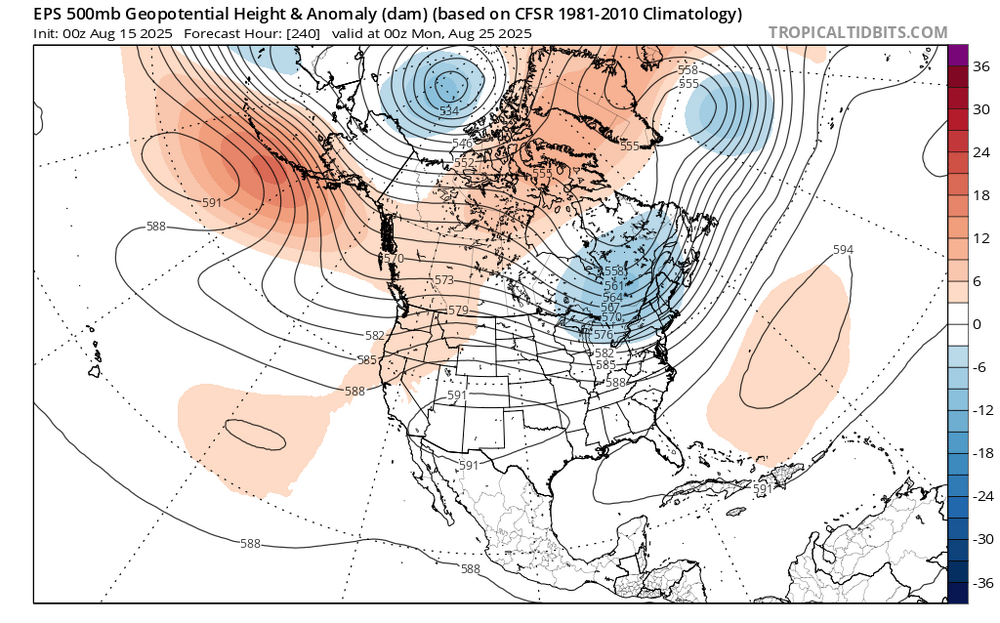
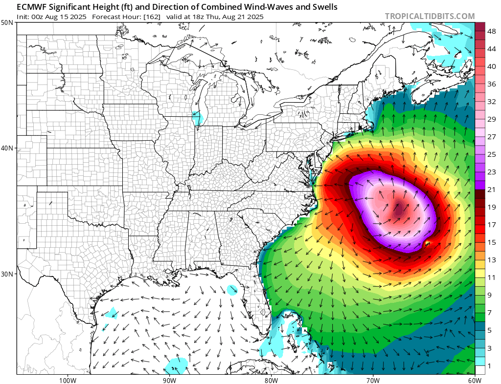
 Next week looks like what the surfers have been waiting for all summer. The best August hurricane swell that we have seen in years. The unusual part with the set up is how much smoke pools just to our SW as the Erin recurves OTS. So rather than much rain, we could see the smoke move into the area as Erin phases with the 50/50 low and another upper low from Hudson Bay heads for SE Canada. https://atmosphere.copernicus.eu/charts/packages/cams/products/aerosol-forecasts?base_time=202508150000&layer_name=composition_aod550&projection=classical_north_america&valid_time=202508200000