All Activity
- Past hour
-
Looks like we should reach into the lower 80s for temps
-

E PA/NJ/DE Spring 2025 Obs/Discussion
RedSky replied to PhiEaglesfan712's topic in Philadelphia Region
.10" more overnight no mercy from the rain gods 10.60" May ...FLOOD WATCH IN EFFECT FROM THIS EVENING THROUGH SATURDAY MORNING... -
-
Well seems our weenie handbook "SPC playing catch-up" checkbox could also be getting checked
- 797 replies
-
- 1
-

-
- severe
- thunderstorms
- (and 2 more)
-

Central PA Spring 2025
Itstrainingtime replied to canderson's topic in Upstate New York/Pennsylvania
Elliott has been very active on X this morning with lots of updates on tonight's heavy rainfall and severe weather potential. Worth a look if interested. -
Central PA Spring 2025
Itstrainingtime replied to canderson's topic in Upstate New York/Pennsylvania
That's helpful, thank you! -
Central PA Spring 2025
Itstrainingtime replied to canderson's topic in Upstate New York/Pennsylvania
So obviously it wasn't an isolated occurrence. I wonder what it was attributed to - was there a warm front that went through, a weak pulse of energy, etc.? Whatever it was it missed Maytown. I've been doing okay this month. -
the only solution is to not get sick
-
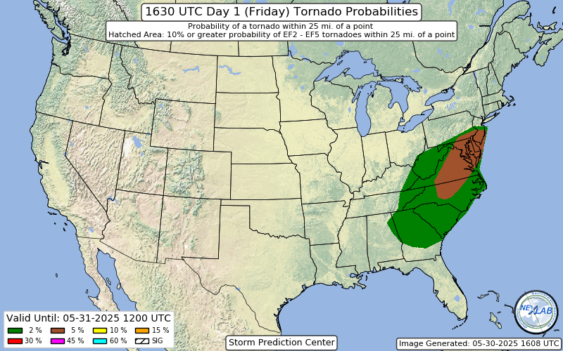
Day 1 Convective Outlook NWS Storm Prediction Center Norman OK 1105 AM CDT Fri May 30 2025 Valid 301630Z - 311200Z ...THERE IS AN ENHANCED RISK OF SEVERE THUNDERSTORMS OVER PORTIONS OF CENTRAL AND EASTERN NORTH CAROLINA...MUCH OF SOUTH CAROLINA...AND EAST-CENTRAL GEORGIA... ...SUMMARY... Scattered to numerous severe storms are possible this afternoon and evening, with 55-70 mph gusts capable of wind damage extending from the Mid-Atlantic states into the Southeast. The potential for a few tornadoes exists from the Mid-Atlantic states into the Carolinas. ...Mid-Atlantic/Carolinas and Southeast... Water-vapor imagery shows a potent mid- to upper-level trough over the OH-TN Valleys with this feature forecast to move into the Mid-Atlantic states/Carolinas by late evening. In response to this shortwave trough, a deepening surface cyclone will move from the KY/WV border east-northeastward along a quasi-stationary front into southeast PA/NJ by evening. A trailing cold front will move across parts of the Southeast, Carolinas, and Virginia. Wind profiles across the warm sector of the deepening cyclone will be seasonably strong, but instability is expected to be tempered by weak midlevel lapse rates and substantial cloud cover. As large-scale ascent with the approaching shortwave trough develops across the warm sector, thunderstorms are expected to develop along and near the cold front. A mix of cells and linear bands will gradually evolve into broken band convective structures with time as storms move east. Strengthening 700-mb flow (40-50 kt) amidst diurnally steepened 0-2 km lapse rates will favor strong to severe gusts. Damaging winds (55-70 mph) are expected to be the primary severe hazard, although a tornado threat will exist primarily with bowing segments. Farther north, the northern extent of a destabilizing warm sector immediately ahead of the deepening surface low, will favor an increasing severe risk this afternoon. Scattered storm development is initially forecast near the higher terrain with additional cellular development expected (consistent signal in recent HRRR runs) in the northern VA to southeast PA corridor late this afternoon and especially into the evening. Given the moist low levels and favorably shaped hodographs in proximity to the surface low, have enlarged 5-percent tornado probabilities for a supercell-tornado risk. Some consideration for higher tornado probabilities was given, but confidence was too low at this time. Damaging gusts and large hail are also possible with the stronger storms.
- 797 replies
-
- 1
-

-
- severe
- thunderstorms
- (and 2 more)
-
Health insurance costs skyrocketing as well...
-
10% tor probs were considered... woah @Kmlwx @high risk
-
Looks like we will eek below normal for the month tomorrow (on the last day of the month).
-
Very big expansion of the 5% Tor in the latest outlook…
- 797 replies
-
- 1
-

-
- severe
- thunderstorms
- (and 2 more)
-
The more northern track of the surface low likely reduces the flash flood threat for most of us, but it definitely increases the severe threat. Surface winds may end up too light, but if they’re not, some of the morning guidance does show enough turning in the low levels to generate favorable hodographs. The 12z HREF reflects this with a notable increase in the probabilities for good UH values into the DC/Baltimore region, relative to earlier guidance, and I would not be surprised if the 1630 outlook brings the 5% TOR further north.
- 797 replies
-
- 3
-
-
-
- severe
- thunderstorms
- (and 2 more)
-
good point, try running a couple of them. They really work well, I have one in my 500sf garage that dries it out in no time
-

May 30th 2025 Severe Weather Potential
SEwakenosnowforu replied to kayman's topic in Southeastern States
These clouds are killing our chances. I think SC has the best chance. -
and don't forget New Jersey river flooding
-
it's not off topic that ugly stuff can start coming in here as early as Sunday.
-
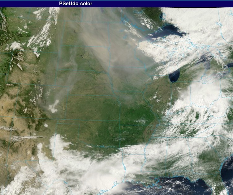
Wow that looks like June 2023, I can literally see the Martian dust storm over the Northern Plains.
-
it looks like air pollution to me, this is what our skies looked like in June 2023. Mars dust storm redux.
-
With the massively shifting precip totals over the last few days, including everything from a near complete miss on the 3k NAM to a proper 4.8 inch NAMming and some big numbers showing for several Euro cycles mid-week, it's yet another reminder of the falsity of "this only happens in with east coast storms winter" (which I know most of us know).
-
You know it's at least somewhat intriguing when @andyhb pops into the Mid-Atlantic forum. And as always, thanks for your insight/thoughts!
-
Off topic for this sub forum but that is some nasty smoke over the northern plains. Thankfully the prevailing flow will keep it away from the Northeast at last for now.
-
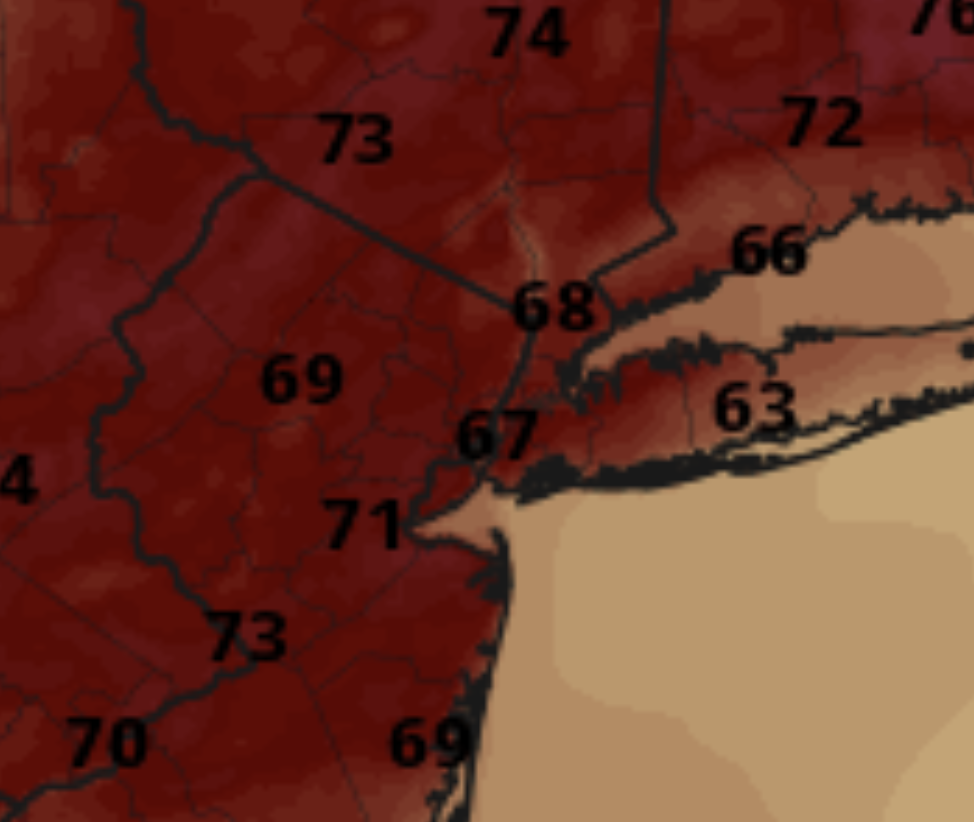
The color scheme on Pivotal is absurd. Nothing about this map says 60s and low 70s. This map looks like it should be 80s and 90s:
-
This is my favorite summer weather. Sunny Morning after an overnight rain, not too hot but still muggy enough to be like morning in Borneo. Smells fresh outside. Unfortunately box turtles love it too, and it was carnage on the back roads on my way to Annapolis this morning.