All Activity
- Past hour
-

White Christmas Miracle? December 23-24th
SouthCoastMA replied to Baroclinic Zone's topic in New England
how bad is the FV3 Hi-Res? shows some promise here for christmas eve and maybe on Christmas Day for some scattered snow showers along East coastal mass -

White Christmas Miracle? December 23-24th
Spanks45 replied to Baroclinic Zone's topic in New England
1.4" should probably do it....temp has creeped to freezing and the radar looks pretty weak.... -
 Just NW of Middletown. When I looked out at 830 it was vomiting snow ! That is next step in intensity after "puking" snow.
 -
 As expected, absolutely no snow here on CT coast. Light rain. .
 -
32.4° light snow 1.25" so far
-

White Christmas Miracle? December 23-24th
Lava Rock replied to Baroclinic Zone's topic in New England
Blue sky, sunny in PWM -
 32.4° light snow 1.25" here as of 10:00am in Cornwall. Missed out on that band but not complaining.
 -
I predict today's 12z gfs goes back to tease mode
-

White Christmas Miracle? December 23-24th
Sey-Mour Snow replied to Baroclinic Zone's topic in New England
Roads were treated thoroughly in Seymour, just snowed hard enough to stick for 4 hours .. light snow now for a while it seems before we pick up around noon.. Sitting at 1.5" -
 Rain has given way to moderate snow in Kearny, nj. Yuggeeeeee flakes. Starting to stick.
 -

White Christmas Miracle? December 23-24th
The 4 Seasons replied to Baroclinic Zone's topic in New England
0.7" light rain now -

White Christmas Miracle? December 23-24th
jbenedet replied to Baroclinic Zone's topic in New England
Too low in midcoast Maine to Portland. 6z EPS had 1” qpf. There will be a over a foot locally there. Also think this is too high over here. This map appears as more of an uncertainty cast as to where the band sets up… The band will be about 100 miles wide; go with 2” outside of that and call it a day. -

White Christmas Miracle? December 23-24th
Brian5671 replied to Baroclinic Zone's topic in New England
No Feb week off here anymore just a long weekend. First 5 days are made up in June then they take from April break...which I have not seen happen in the 12 yrs my kids have been in school here Today's a half day throwaway day with kids watching movies-my sons didn't want today canceled lol. (which it wasnt) -
White Christmas Miracle? December 23-24th
Brian5671 replied to Baroclinic Zone's topic in New England
Yep if we end up with a bunch of snow events even small those days add up and we still have schools with no AC so deep into June we go....last few years have been lean so it's worked out but this winter might be different -

White Christmas Miracle? December 23-24th
weatherwiz replied to Baroclinic Zone's topic in New England
This didn't happened when I was in school (although maybe it was being discussed when I was in high school and implemented shortly after) but do they use days from like February or April break to make up for snow days instead of going deeper into June? I know some districts had done this. -
(002).thumb.png.6e3d9d46bca5fe41aab7a74871dd8af8.png)
Central PA Winter 25/26 Discussion and Obs
ChescoWx replied to MAG5035's topic in Upstate New York/Pennsylvania
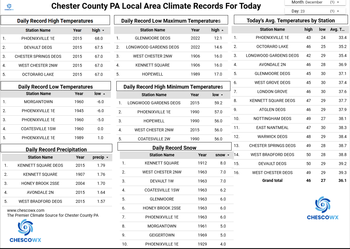
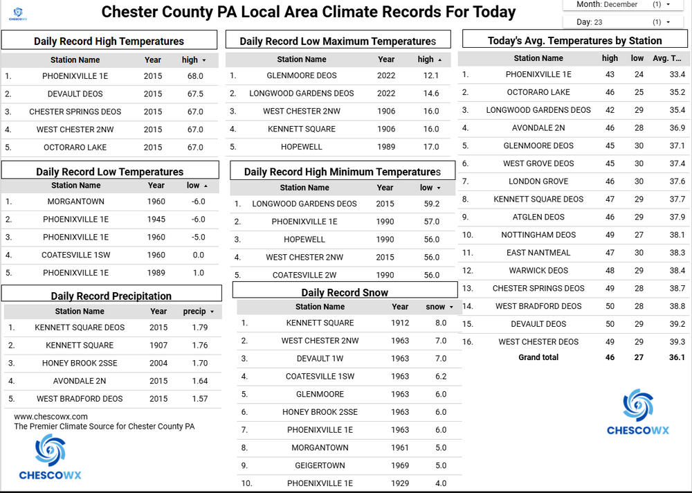
We ended up with 1.0" of snow here in East Nantmeal this morning. This was our 5th winter event of the young winter season. The 10.4" of snow recorded this month here in EN is the snowiest December since the 11.7" of snow back in 2017. This is the 6th snowiest December in the 23 years I have been at this location. We get a brief reprieve from the winter weather through Christmas Day with afternoon temperatures just a few degrees below normal for the big day. Our next winter event looks like it could be our most impactful so far this season. Snow should arrive around noon on Friday we should then see a change to first sleet and finally freezing rain as we move through the afternoon. Temperatures during the storm on Boxing Day are likely to only warm into the upper 20's to near 30 degrees so what falls will likely be frozen in some form. We warm to near normal on Sunday before we turn much colder again on Monday and look to see below normal temperatures through the remainder of 2025 and into the first week of 2026.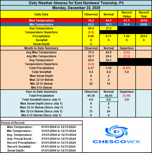
-
E PA/NJ/DE Winter 2025-26 Obs/Discussion
ChescoWx replied to LVblizzard's topic in Philadelphia Region
We ended up with 1.0" of snow here in East Nantmeal this morning. This was our 5th winter event of the young winter season. The 10.4" of snow recorded this month here in EN is the snowiest December since the 11.7" of snow back in 2017. This is the 6th snowiest December in the 23 years I have been at this location. We get a brief reprieve from the winter weather through Christmas Day with afternoon temperatures just a few degrees below normal for the big day. Our next winter event looks like it could be our most impactful so far this season. Snow should arrive around noon on Friday we should then see a change to first sleet and finally freezing rain as we move through the afternoon. Temperatures during the storm on Boxing Day are likely to only warm into the upper 20's to near 30 degrees so what falls will likely be frozen in some form. We warm to near normal on Sunday before we turn much colder again on Monday and look to see below normal temperatures through the remainder of 2025 and into the first week of 2026.
-

White Christmas Miracle? December 23-24th
CoastalWx replied to Baroclinic Zone's topic in New England
Surprised it wasn’t treated then. I don’t know, another day into deep summer for the schools with 1” is dumb, but people these days are dumb too. Lawsuits galore. -

Winter 2025-26 Medium/Long Range Discussion
Harry Perry replied to michsnowfreak's topic in Lakes/Ohio Valley
Been watching that as well. GFS most bullish especially out your way. Will be something to watch the next couple of days. -
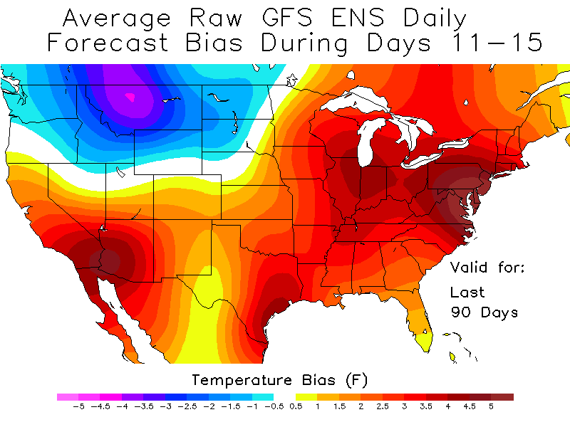
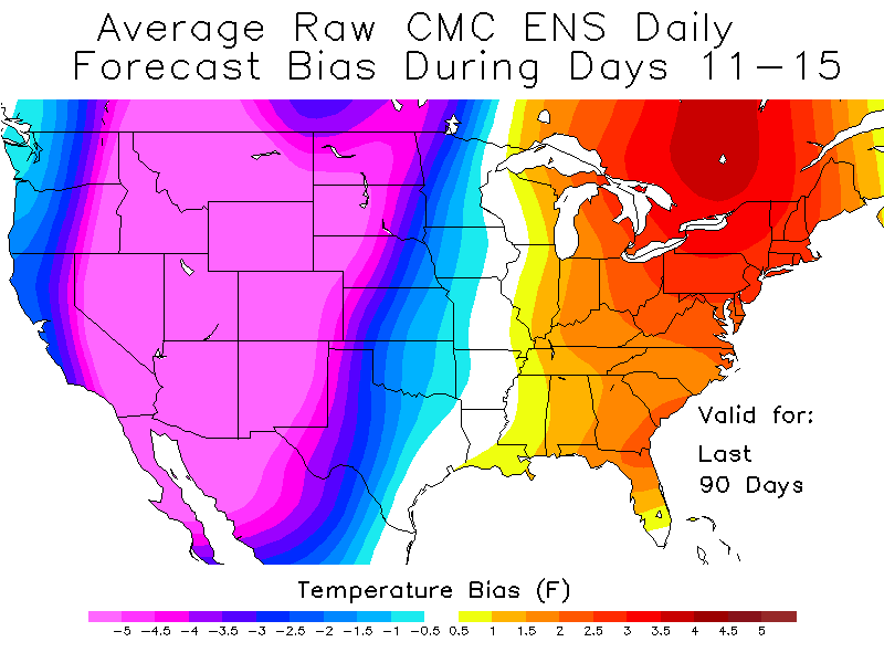
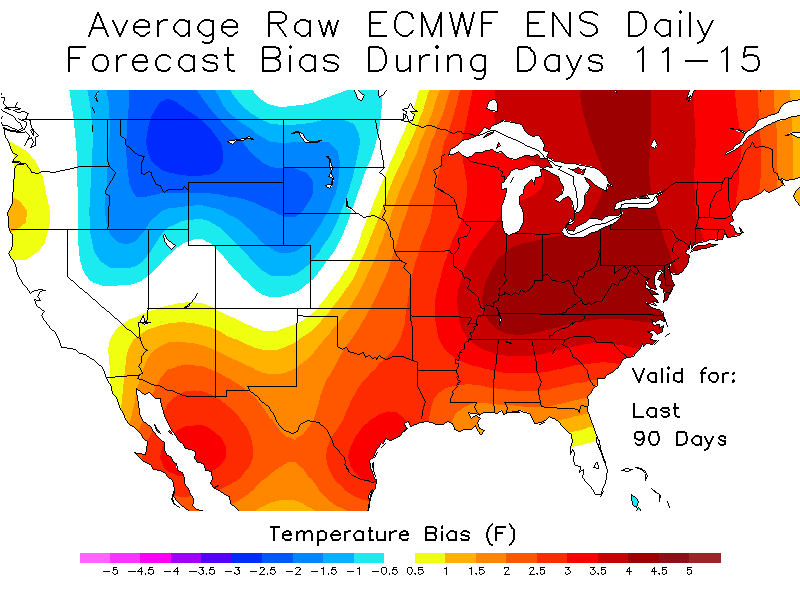
This is the first time in a while that the 11-15 day ensembles have had this much of a warm bias in the East. https://frontierweather.dtn.com/verification.html
-
White Christmas Miracle? December 23-24th
Sey-Mour Snow replied to Baroclinic Zone's topic in New England
Odd little event.. The good news is for NEMASS, hires stuff brings in some steady snow after dark , hopefully can maximize accumulations where it's all snow.. -

White Christmas Miracle? December 23-24th
Mr. Windcredible! replied to Baroclinic Zone's topic in New England
Schools open here too...only a half day...but temp now up to 33 and only managed about 0.4", pavement mostly bare. -
White Christmas Miracle? December 23-24th
Brian5671 replied to Baroclinic Zone's topic in New England
CT banned remote learning a few years back (in public schools) b/c it was such a disaster-so if there's a snow day it's getting made up in June. -
Man that's ugly. Interestingly, not as much of an upward trend as i was expecting. Also, what the heck was going on in 1983? I was two at the time so had no memory.
-
 a little over an inch so far on all surfaces - looks beautiful out with big flakes falling.