All Activity
- Past hour
-
you weren't kidding lol. nearly all of this between hour 200-300. start building your arks
-

2025-2026 ENSO
donsutherland1 replied to 40/70 Benchmark's topic in Weather Forecasting and Discussion
This is an exercise aimed at seeing if human subjectivity can be removed with an algorithm selecting analogs with a focus on the North American domain. More broadly, can analog development become an objective exercise. I don't know if that's possible right now. As noted in the discussion, I don't like one of the three that the algorithm chose (2011-12). I also include one (2024-25) that the algorithm did not choose. I will periodically post updates on this experiment. If there is merit in the algorithmic approach, one should see 500 mb patterns come more in line with the composite idea over 1- and, especially 3-month periods. The focus on this set is fall 2025 and winter 2025-26. That there is some similarity at 500 mb for winter 2025-2026 to the ECMWF forecast suggests that there's consensus on the boundary conditions and how the pattern might turn out. I don't believe the winter 500 mb idea from the experimental set precludes some intrusions of cold air into the CONUS during the winter, particularly the central U.S. -

Monday, October 20, 2025 Squall Line Potential
Lava Rock replied to weatherwiz's topic in New England
just dumping outside my work window in pwm -
12z euro is biblical rains late next week
-

Mid to long range discussion- 2025
WinstonSalemArlington replied to wncsnow's topic in Southeastern States
Will the Triad have its first official 30s of the season during the upcoming cool snap? -
12z Euro is similar to past runs.... stays relatively weak and is able to not get pulled north early, then blows up south of Jamaica and is quickly yanked north by the next trough.
-

Spooky Season (October Disco Thread)
WxWatcher007 replied to Prismshine Productions's topic in New England
It’s highly unlikely to impact the U.S. but if the trough taps into the moisture feed or even better somehow 98L gets partially absorbed into a big trough we could get some interesting wx, but more boredom is most likely. -

Spooky Season (October Disco Thread)
ineedsnow replied to Prismshine Productions's topic in New England
Or not gets kicked out -
Spooky Season (October Disco Thread)
ineedsnow replied to Prismshine Productions's topic in New England
@WxWatcher007 Euro might be interesting -
Tropical Weather Outlook NWS National Hurricane Center Miami FL 200 PM EDT Mon Oct 20 2025 For the North Atlantic...Caribbean Sea and the Gulf of America: Caribbean Sea (AL98): Recent satellite wind data indicate the tropical wave located over the eastern Caribbean Sea still lacks a closed circulation, but continues to produce a concentrated area of showers and thunderstorms near and to the east of the wave axis. Compared to yesterday, surface observations suggest the circulation is gradually becoming better defined, and environmental conditions are forecast to become a little more conducive for development as the system slows its forward motion. A tropical depression or storm is now likely to form over the next day or two as it moves into the central Caribbean Sea. Regardless of development, heavy rainfall and gusty winds are possible over portions of the ABC Islands during the next couple of days. Interests in Puerto Rico, Hispaniola, Jamaica, and Cuba should monitor its progress as there is a risk of heavy rain and flooding, strong winds, and rough surf later this week. For addition information on this system, including Gale Warnings, please see High Seas Forecasts issued by the National Weather Service. * Formation chance through 48 hours...high...70 percent. * Formation chance through 7 days...high...90 percent. && High Seas Forecasts issued by the National Weather Service can be found under AWIPS header NFDHSFAT1, WMO header FZNT01 KWBC, and online at ocean.weather.gov/shtml/NFDHSFAT1.php $$ Forecaster Papin
-
Spooky Season (October Disco Thread)
ineedsnow replied to Prismshine Productions's topic in New England
So that 941mb member on the GEFS about to move in day 8 won't happen? -

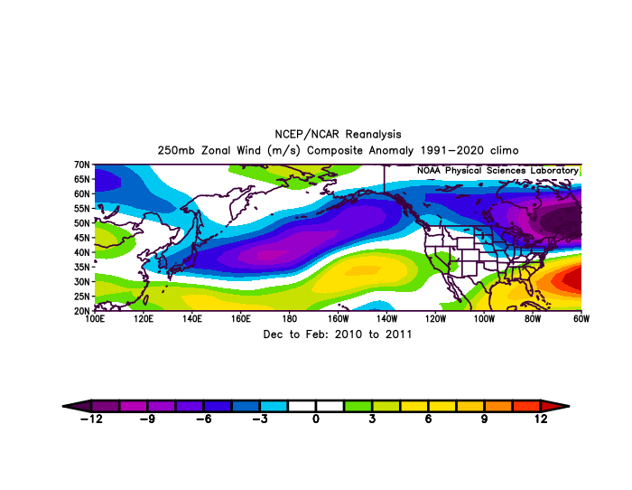
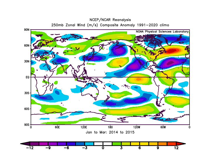
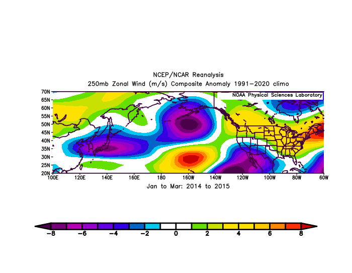
2025-2026 ENSO
PhiEaglesfan712 replied to 40/70 Benchmark's topic in Weather Forecasting and Discussion
2009-10 and 2010-11: 2013-14 and 2014-15: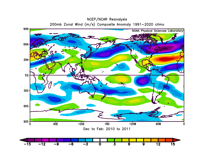
-
Interesting read https://www.facebook.com/share/p/1Zn5LKmxi3/
-
Severe drought very likely to expand across the Carolina’s and we are now likely to see back to back months with less than 1” of rain here. Not good, one bad symptom of the lackluster hurricane season
-
I'm 65 now....I have written records that began uninterrupted when I was 13. I think ive been doing this since maybe 10 years of age or maybe younger. Come to my house and see all my weather equipment I've purchased over the decades...my basement looks like a weather museum lol.
-
Same as Don, from my weather station, I've had one for 25+ years, on my third station now. I kept general weather notes going back longer that that but got more detailed with my observations 20 years ago. It seemed kinda pointless at times in the beginning, many will say its pointless now but I find it interesting to look back now that there is a decent chunk or information to look at.
-
Spooky Season (October Disco Thread)
WxWatcher007 replied to Prismshine Productions's topic in New England
No hurricane is coming lol, but the trend with 98L has been further south and west given its overall structure. I do think there’s a legitimate chance that some moisture gets entrained in the end of month trough swinging in from the west, but we’re an eternity away from all that. -

Spooky Season (October Disco Thread)
Damage In Tolland replied to Prismshine Productions's topic in New England
We see a few of these flung back across your face -
Not sure how accurate google is, but what i was able to find for Teterboro airport is from 9/1/24 to present is 48.12" of rain, just under half of that was from september to new years last year. 2025 is only at 25.74 YTD.
- Today
-

Monday, October 20, 2025 Squall Line Potential
Torch Tiger replied to weatherwiz's topic in New England
'Grats -

Spooky Season (October Disco Thread)
ma blizzard replied to Prismshine Productions's topic in New England
imagine if that run went out another 24 hours -
JB was already hinting at the Sandy analog in the euro week 3 window.
-

Monday, October 20, 2025 Squall Line Potential
dendrite replied to weatherwiz's topic in New England
61° RA 1.00” -

Spooky Season (October Disco Thread)
CoastalWx replied to Prismshine Productions's topic in New England
Canadian would have been insane. But it’s the Canadian. -
That's from my station on si.


