All Activity
- Past hour
-

11/8-11/10 First Snow and Lake Effect Event
donsutherland1 replied to Geoboy645's topic in Lakes/Ohio Valley
For reference, some historic data for Chicago: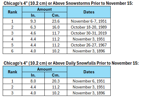
-

November 2025 general discussions and probable topic derailings ...
Brewbeer replied to Typhoon Tip's topic in New England
-

11/8-11/10 First Snow and Lake Effect Event
Chicago916 replied to Geoboy645's topic in Lakes/Ohio Valley
Can't remember seeing "snow and a chance of thunderstorms" in a p&c before. Was laughing thinking about nadocast outlining the shore during the event in a forecast, but I'm sure waterspouts are filtered out from forecasts. -

Central PA Fall Discussions and Obs
Superstorm replied to ChescoWx's topic in Upstate New York/Pennsylvania
Good for Lakes Region. Could see some significant LES. Not good climo period for us. We will probably be on warm side after that period 3 to 4 week period, as climo improves. . -

11/8-11/10 First Snow and Lake Effect Event
hawkeye_wx replied to Geoboy645's topic in Lakes/Ohio Valley
The warmer models were correct for my area. I did not see a single flake. -

11/8-11/10 First Snow and Lake Effect Event
nwohweather replied to Geoboy645's topic in Lakes/Ohio Valley
What a surprise 2” here in Toledo! -

Central PA Fall Discussions and Obs
Mount Joy Snowman replied to ChescoWx's topic in Upstate New York/Pennsylvania
And just like that it is absolutely dumping here. -

Mid to long range discussion- 2025
WinstonSalemArlington replied to wncsnow's topic in Southeastern States
HRRR -
Lastest AO update 11/09/25 - an increased negative forecast without a return to going positive. Looking good !
.thumb.png.0c777d06591b056055b5e4df557366c1.png)
-
Dusting overnight. First official flakes of the season at MSP.
-
Indeed, Don! The current and recent KCHS NWS forecasts for KSAV have been for 30 on 11/11 in a windy freeze. If that were to verify, it would be the earliest 30 or colder since way back in 1976! However, latest and recent model consensus is suggesting that 30 is on the low end (Icon). ICON actually warmed some from 27s on Sat runs. Latest ICON/GFS/CMC/Euro/UKMET have 30/32/33/33/34. If this were a radiational cooling night, I’d likely favor the low end per slight warm bias of consensus. But with it being windy, I’m currently thinking near the model avg of 32. However, if the model consensus were to cool, I’d adjust colder.
-

11/8-11/10 First Snow and Lake Effect Event
OrdIowPitMsp replied to Geoboy645's topic in Lakes/Ohio Valley
What is the all time November snowfall record for Chicago? -
 Week looks kind of crappy. The lack of sun kind of breaks the soul
 -

November 2025 general discussions and probable topic derailings ...
dendrite replied to Typhoon Tip's topic in New England
Fire up the Trammell Starks -
November 2025 general discussions and probable topic derailings ...
dendrite replied to Typhoon Tip's topic in New England
There’s definitely a ptype boundary up there with 33s north of there and 35/36 south. -

November 2025 general discussions and probable topic derailings ...
Lava Rock replied to Typhoon Tip's topic in New England
36f. Wet flakes. Sent from my SM-S921U using Tapatalk -

11/8-11/10 First Snow and Lake Effect Event
A-L-E-K replied to Geoboy645's topic in Lakes/Ohio Valley
Taking the under seems prudent, definitely surprised how hard LOT is hitting this -
I mean @PhiEaglesfan712 has a point with that 2010 Niña being much stronger. That aside, back in 2010 when HM was still active on here, he perfectly called the massive -NAO/-AO blocking more than a month before it even happened. He blamed it directly on the solar minimum with very low geomag that was in place, he said the blocking and stratospheric/tropospheric coupling would not have developed without it…..
-
From Paul Roundy, this shows - NAO and Greenland blocking might be a frequent player during the upcoming winter.
.png.cfe1120bace46aad74c150b5c4069728.png)
-

2025-2026 Fall/Winter Mountain Thread
Buckethead replied to Buckethead's topic in Southeastern States
Currently at 48° in Wolf with clouds moving in. The front is on our door step, so I think that will probably be my high for the day. Just upstream of us, KMRX thinks the advisories may need to be upgraded/expanded later today. KGSP has me receiving 2-3". I believe they're just being conservative as usual. I guess we'll see. 099 FXUS64 KMRX 091154 AFDMRX Area Forecast Discussion National Weather Service Morristown TN 654 AM EST Sun Nov 9 2025 .DISCUSSION... Issued at 151 AM EST Sun Nov 9 2025 Wintry precipitation is going to be a concern in higher elevation areas and an initial Winter Storm Warning and Winter Weather Advisory have been hoisted up to account for this. It`s highly likely that some adjustments or outright expansion of snowfall totals, areal coverage of these headlines, or both, will be needed on the day shift today. Sent from my SM-S908U using Tapatalk -

November 2025 general discussions and probable topic derailings ...
CoastalWx replied to Typhoon Tip's topic in New England
Too many candles at the altar? -
November 2025 general discussions and probable topic derailings ...
CoastalWx replied to Typhoon Tip's topic in New England
At least a mix -
I’m tossing 95 but not 10.
-
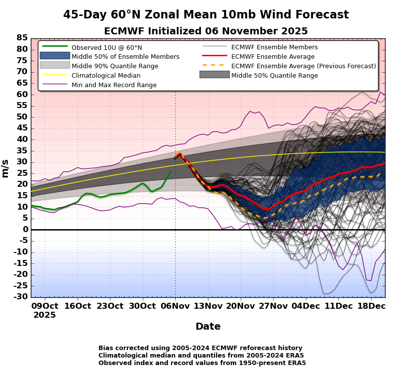
Latest ECMWF update regarding the 45 day 60 degree N Zonal Mean 10mb Wind Forecast. Of note, the ensemble average in this update is slighter higher than the previous ensemble forecast, however, still bullish for a weak PV.
-
November 2025 general discussions and probable topic derailings ...
CoastalWx replied to Typhoon Tip's topic in New England
Looks like it’s snowing in Center Harbor


.png.e34b56b85f6da1a4cc877150ecd8285d.png)


