All Activity
- Past hour
-
I think maybe like last year we might have lucked out with the -PDO peaking too early. Its hard to sustain a -3 or 4 from July-August through an entire winter. Last year it basically bottomed out in October and then it was -1 during the winter. Could see the same thing happen again though I'd be wary of it not averaging slightly more negative than last winter.
-
Yeah. Stein at work means CoC can play
-
It didn’t work out for the 2019-2020 winter since the rest of the Pacific was so warm with the record IOD reversal which supercharged the SPV during the fall when it was so positive.
-

September 2025 OBS-Discussion centered NYC subforum
steve392 replied to wdrag's topic in New York City Metro
Was very humid feeling when i left for work at 6am. -
It is pretty hot in the sun today
-
The low volume is why it was so much easier to reach the North Pole this summer. Extent is only a one dimensional measurement of where the edge of the ice field is. But now there is so much open and thin ice behind that edge that it’s losing its relevance as a useful metric for describing the state of the sea ice. Since in the old days there was solid MYI older ice behind the edge of where the ice was. The Barents Observer @thebarentsobserver.com Follow "What struck me most: the ease of access through what used to be a far more ice-covered region", expedition leader Jochen Knies tells us, "We had been sailing through open water at 6–8 knots, something unthinkable three decades ago." See our report straight from the North Pole! #climatechange “I didn’t hear the usual grinding of ice” When a Norwegian vessel reached the North Pole this week, the scientific team made an alarming discovery. www.thebarentsobserver.com September 4, 2025 at 7:09
-
Correct
-
Yeah. Volume doesn't really tell you much about what's happening now. The low volume is the result of decades of warming. We could have an asteroid impact the planet today and cool it 3 degrees and the volume would still be low next year.
-
Saw a few thunderheads off to the east earlier. Top 2 event of September so far.
-

2025 Atlantic Hurricane Season
LibertyBell replied to BarryStantonGBP's topic in Tropical Headquarters
Yes, otherwise we would be going into a 70s/80s type of inactive period right now. -
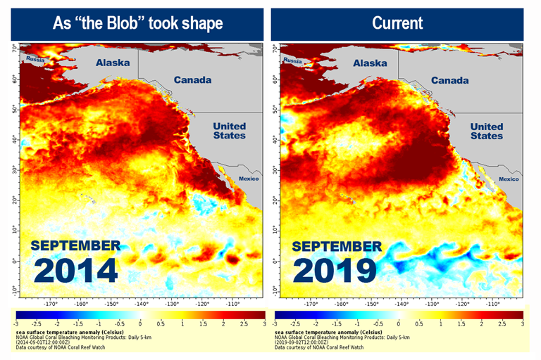
I thought it was a warm NE Pac that had some correlation to a cold E US winter rather than a warm N Pac overall, which is what I believe is the current case.
-
2025 Atlantic Hurricane Season
LibertyBell replied to BarryStantonGBP's topic in Tropical Headquarters
The intriguing thing about last year which is being repeated to a more extreme extent this year is the long period of inactivity when you expect things to be very active. It was the tropical equivalent of a book end season, with big activity early and later in the season. Do you have a monthly breakdown of tropical activity from last season, Larry? Thanks! -
Hey Liberty, 2024 came in less active than, for example, the initial forecasts from CSU. But the season was still solidly above avg and it was a horrific season for the SE US: 2024 North Atlantic Summary Named Storms (vs 1991-2020 Normal) Hurricanes (vs 1991-2020 Normal) Major Hurricanes (vs 1991-2020 Normal) Total ACE (x104 kt2) (% Difference of 1991-2020 Normal) Total Direct Deaths Total U.S. Damagee ($million) 18 (+4) 11 (+4) 5 (+2) 161.5 (+32% ) 274 124,125
- Today
-
This tropical storm will squash some Goombas
-

September 2025 OBS-Discussion centered NYC subforum
qg_omega replied to wdrag's topic in New York City Metro
Anyone else smell smoke -

September 2025 OBS-Discussion centered NYC subforum
donsutherland1 replied to wdrag's topic in New York City Metro
Yes. The temperature has reached 41 on August 28 and September 8-9. -
It makes plausible sense.
-

September 2025 OBS-Discussion centered NYC subforum
uofmiami replied to wdrag's topic in New York City Metro
Not me down here on Long Island. -

September 2025 OBS-Discussion centered NYC subforum
Jersey Andrew replied to wdrag's topic in New York City Metro
Could Wednesday be wet in NYC now? -

September 2025 OBS-Discussion centered NYC subforum
NEG NAO replied to wdrag's topic in New York City Metro
Yes - 64 % Humidity 60 Dewpoint here On the Middlesex/Union County Border in NJ as of 11 am . Air Quality Index is 50 - Hazardous - whats causing that ? -
September 2025 OBS-Discussion centered NYC subforum
LibertyBell replied to wdrag's topic in New York City Metro
Chris is that 41 the season low to date for MPO? -
Ok the ssts are like footprints. Something is making the footprints - ssts depicted aren’t derived in a vacuum. Unless they are and that’s why seasonal models utterly suck.
-
Hold up. We cancel winter on a 6 month snow map but we toss 5 day snow maps. Got it.
-
You have to get them on the second jump. They take a while to recover between jumps. It's like me doing sets of squats. Lol.
-
Euro AI been very consistent with a coastal low next week giving us rain Wednesday-Thursday. Traditional models have been hinting at it, but a lot more inconsistent. Seems after that we may get into a relatively wetter pattern.


