All Activity
- Past hour
-

Central PA Spring 2025
Itstrainingtime replied to canderson's topic in Upstate New York/Pennsylvania
SPC has a lot of central PA in a MRGL risk for tomorrow - meanwhile. MU has been touting a big time severe potential for several days now. He's expecting violent storms later tomorrow. (at least down this way) -
Yeah, that will be good at least. I just hate when it's wall to wall clouds for 72-120 hours this time of year. After we got sunny and windy and 40 degrees for months
-
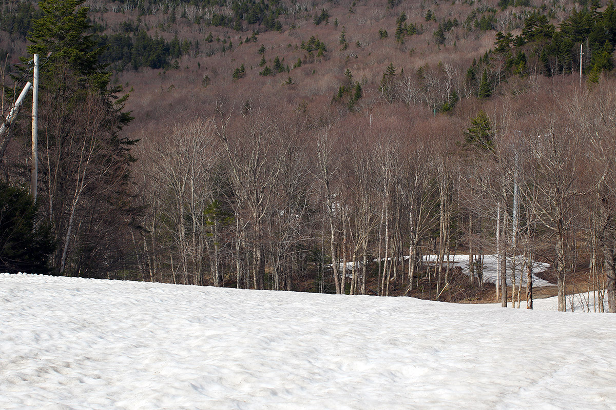
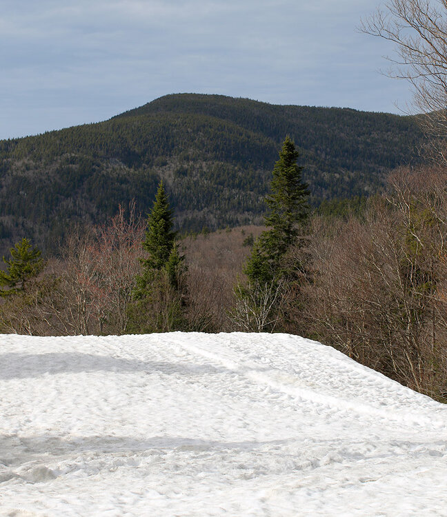
The forecast for the coming days looks fairly unsettled and showery, so I decided to take advantage of the sunny conditions yesterday to get out for a ski tour up at Bolton Valley. I expected that I’d need to head up to the main base at 2,000’ because the Timberline area would be too melted out to offer decent touring opportunities, and indeed that was the case. On the way up the Bolton Valley Access Road, I could see that the Timberline terrain was down to just patchy snow. There are still some continuous routes of snow up at the main mountain though, so that worked out well to get in some afternoon touring. Enough areas of terrain above the main base have melted out to make it practical to go with either hiking or skinning on the ascent. I just had my skis on my pack to simplify things without the need to bring skins, and indeed I found plenty of grassy areas for hiking. The snowpack at Bolton is certainly developing sun cups/melt cups in many areas now, so the turns weren’t as smooth as my past couple of outings, but with the warmth and sun, the snow was definitely soft enough for some decent spring turns.

-
0.35" overnight with some decent thunder around 4am.
-
Only time I've ever seen anything with some visibility is by the water. You can see CBs 70+ miles away. One nice thing about an old girlfriend who lived at the beach lol. Storms were awesome when it's so open. Even ltg 10 miles away makes it seem it's right at your house.
-
Or serving franks at a little league game.
-
~ 1/2" of rain so far around the TH area, with close to an 1" around the DLH area. Still raining pretty good. Just a blah, wet day, but some rather pleasant, seasonably warm conditions on tap for the 1st week of May.
-
That's where I used to sit at BDL but there is a lot next to the hotel (always forget the name of it) close to the McDonalds which is even better for viewing because you're farther away from that building on the airfield that is a bit across from the McDonalds.
-
The 28.7" at Detroit was over a foot below avg, though Jan & Feb were 2 solid months of excellent conditions for all outdoor things winter (with off and on spurts Nov/Dec), so those who dont just go by numbers would call it a solid winter. The last 10 years, since 2015-16, have seen 2 above avg snow seasons, 2 avg snow seasons, and 6 below avg snow seasons, although with the lowest being 23.5" in '23-24, none have been record low. However, the 10-year avg of 39.1" is only 2" below the longterm avg and 6" below the 1991-2020 avg. The 20-year avg of 46.2" is still 5" above the longterm avg and 1" above 1991-20 avg, and the rolling 30-year avg (1996-2025) is 43.7", which is still approx 1.5" above the longterm avg. So all in all, its purely been a regression to the mean and im looking forward to seeing what the next few winters brings.
-
You sit in McD parking lot lol
-
What I usually do around here is basically find an open field or like a golf course. But it's not technically chasing, I don't chase after the storms...usually get to a spot before the storms get there. But this is why I love BDL...offers a great view on the western horizon. When I go elsewhere in the region...NY or PA then we try and pick a location within a radius where things look "good" and just hope and pray something comes close by lol.
-
1st day of May gave us a high of 85.
-
you can't anyway. You're too obstructed from ground truth in every direction. If not an elevation blocking view it's forest or trees in general ...and if not trees, it's church steeples. Maybe you could photo a steeple, digitally turn it upside down, doctor it up a tad and call it a day - hahaha. hell, they call 'em the 'finger of god' anyway.
-
Measured 0.11" at my house. Definitely wasn't anticipating the thunderstorms given meager instability. There was always a chance of rain but those storms were impressive! Woke me up in the middle of the night.
-
Probably not. Is it ever a chase day in SNE?
-
This is the time of year when cold fronts no longer mean frost advisories.
-
these laboring warm frontal days are a paint drying slog. It's cutting across middle NJ but looking at hourly obs it appears to be moving north and will be up here mid afternoon, unless there's some sudden broader scaled mix out/leap in position which sometimes happens in these tuck regions E of the els.. I could see it being 62/57 murk at 2pm and agonizing ...then at 3:45 pm it's suddenly 77/65 as far N as ASH - Brian should be dammed and damned until tomorrow. If we can peel away more of the mid and high level gunk, then the sun may help to speed this up too. We're less than a week before the doorway into the solar max time of year. Long journey that seemed like a nightmare hallway stretching out of reach this time. I think I'm getting older.
-
17-18 and 20-21 were well above average here (I'm pretty much dead center between Philly and NYC). Again, some of these things are location dependent and picking a big city like many do isn't necessarily accurate. Last year (23-24) I was exactly average due to one sneaky storm that dropped a foot in a small swath. But the same can be said for other winters when a nor'easter gets Long Island/NYC putting them above average snow and gives me an inch since I am 10 miles too west. We are running 3" below average here for the past 8 years, but some area's are much lower, some are higher.
-
Temps look manageable, at least.
-

Texas 2025 Discussion/Observations
Stx_Thunder replied to Stx_Thunder's topic in Central/Western States
SPC D1 enhanced svr risk today over central half of state looks valid, looking at instability/shear parameters. Especially Del Rio - Houston region and south later this afternoon with a front, outflows and peak sfc heating in the region. CAMs as usual, have not been doing well on MCS evolution (even last week) over southern half. If things haven't gotten convectively interesting enough since last week in the state, they likely will next week especially now that May has arrived. To top it off, both Euro & GFS along with ensembles are showing an abnormally deep slow-moving H5 Low nearing the state with stronger ridging further north/east around mid week and lingering front in the state. 'Been like that for days now, but with LN completely gone, and the MJO hanging around the latter phases in or next to the unit circle has me more concerned looking back on past major convective events in the state this time of year like that. Flood threat is bound to increase over the eastern half with MCS activity around through most if not all of next week.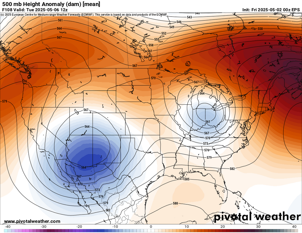
- Today
-
chase day?
-
It’s a blip, it’ll be gone by the next model run. Snow would’ve collapsed by now.
-
hoping for some good CB scapes but that looks like it may deteriorate into a grunge warm sector sky type... which is all distant rumbles. At least it's warm. Saturday's sort of transformed into a deep warm sector day as the week went on.
-
Welcome to severe season!