All Activity
- Past hour
-
32 degree's in Mahwah, Gorgeous chilly morning on my last shift here at the communications center.
-
I caught flurries in the middle of the night on a camera I have along the woods line. The flurries didn’t trigger it but the two bucks going back and forth did. Hard to tell exactly how big but one appeared to be a young 4 pointer, the other larger one appeared to be at least a 6, possibly 8, pointer. As a result of the clouds it didn’t get a cold as forecast here, off by about 5 degrees, low of 34.
-

November 2025 general discussions and probable topic derailings ...
WinterWolf replied to Typhoon Tip's topic in New England
Oh agreed. .I’ve said similar. He may be taking a morning swim down there as we type? -
our cutters showing a real propensity to go poof and the big flip cold looking like a dud sad
-

November 2025 general discussions and probable topic derailings ...
CoastalWx replied to Typhoon Tip's topic in New England
I mean it’s a warmer spot, but I’ve been commenting about that station for over a year. There’s no reason why it should be the warmest spot in all of SNE in this setup. -
November 2025 general discussions and probable topic derailings ...
WinterWolf replied to Typhoon Tip's topic in New England
He’ll be posting palm tree pictures in the corners of buildings…and saying the low today was 45 -
The only Southeast ridge component that really matters is on the day of the storms like last winter. Even if a Southeast ridge isn’t showing in the means, if a storm is tracking through the Great Lakes we will get the Southeast ridge to flex for a day before the storm cuts to our west or hugs the I-78 to I-84 corridor. Long range ensembles never show this since they are too smoothed out in the long range and have trouble seeing the individual shortwaves. We really haven’t seen a gradient pattern work closer to NYC in a long time due to this for more than light snows.
-
Bad sign.
-
I think we need a title change here. No warm season here this A.M.
-
Yeah, but that isn’t really cold for those areas either. Remember, the lows in the UHI zones are proportional to the ones outside the urban areas. Since you aren’t going to get very cold with radiational cooling if the airmass isn’t that cold to begin with. Even places which great radiational cooling like Saranac Lake have only dropped to 19° by November 16th. This is the 2nd warmest minimum on record through 11-16 at the airport. Time Series Summary for SARANAC LAKE ADIRONDACK REGIONAL AP, NY Warmest lows 9-1 to 11-16 Click column heading to sort ascending, click again to sort descending. 1 2006-11-16 21 1 2 2025-11-16 19 0 3 2016-11-16 18 0 - 1998-11-16 18 0 5 2014-11-16 17 0 6 2010-11-16 16 0 - 2000-11-16 16 1 8 2021-11-16 15 0 9 2024-11-16 13 0 10 2011-11-16 12 0 - 2009-11-16 12 0 12 2008-11-16 11 0 - 2005-11-16 11 1 14 2015-11-16 10 0
-
38 right now
- Today
-
Still lightly snowing as I wake up , looks like maybe an inch or two - really pretty as I look out. Hope we get days like this down here this winter.
-
 Deep winter run this morning with the wind
 -
November 2025 general discussions and probable topic derailings ...
CoastalWx replied to Typhoon Tip's topic in New England
KHVN 40 when everyone else there is well mixed and 36-37. We toss KHVN. @BrianW -
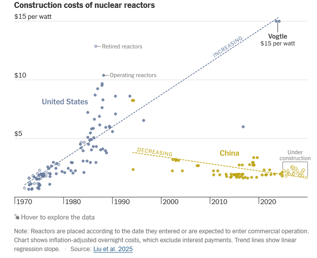
I'm open to any non-fossil energy source, let the market decide. In the case of nuclear, the US will need to lower cost to deploy significant volume. https://www.nytimes.com/interactive/2025/10/22/climate/china-us-nuclear-energy-race.html?unlocked_article_code=1.vk8.p953.GyoqfHxUqxEK&smid=url-share
-
@Gawx Sunspots over 110 so far this month. Very high geomag continuing as well, as has been the case since solar activity picked back up in August. If this follows the trend you found since 1979, this is very likely to be a +NAO winter
-
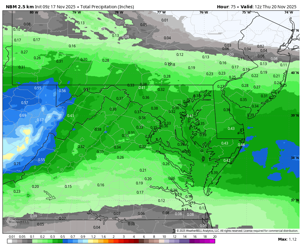
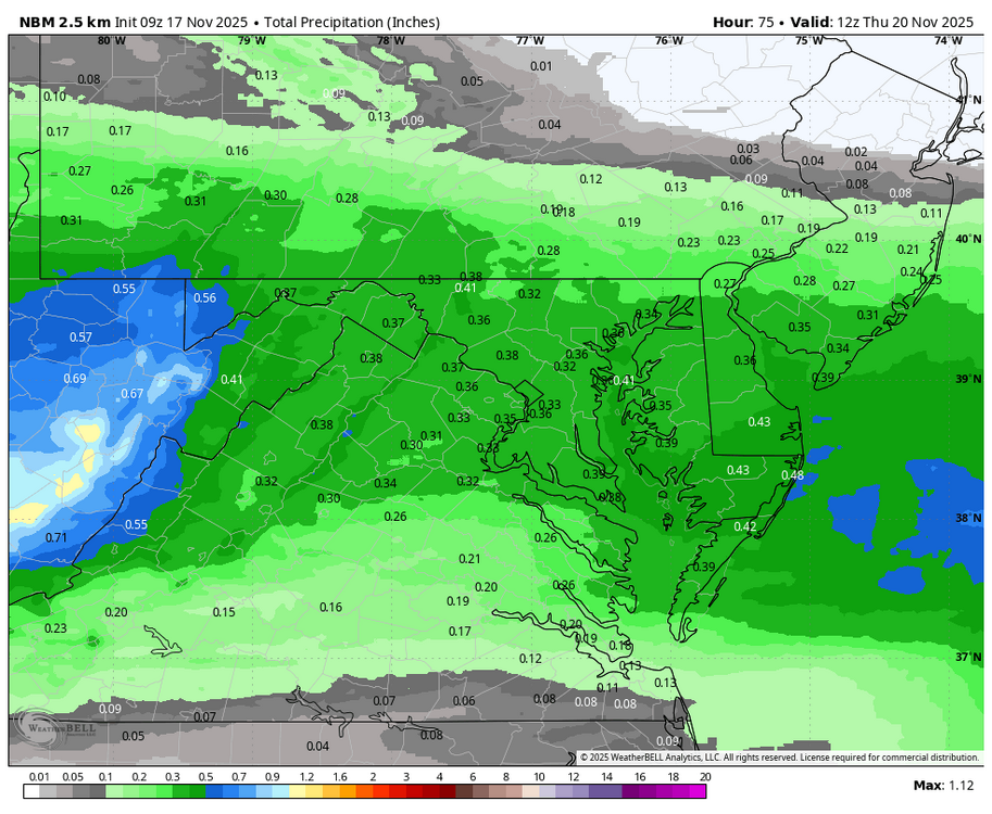
WB 9Z NBM for late Tuesday/ early Wed. We need every drop...
-
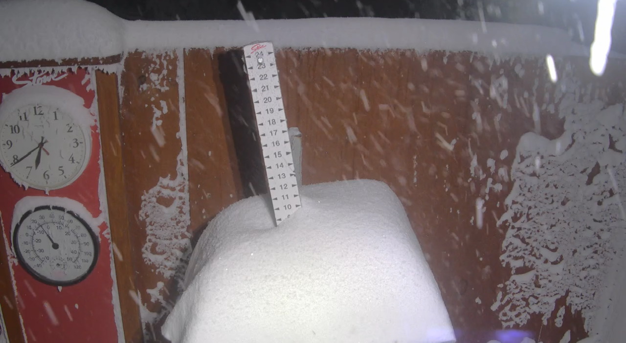
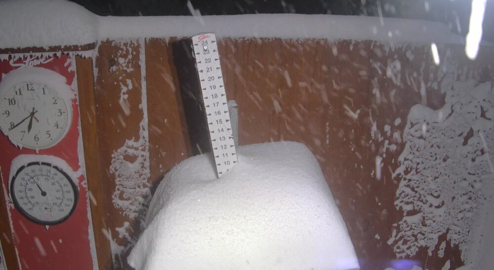
The nocturnal blocking came through and organized it really well. It hammered from like 10pm onward. All good, ha. Worried for nothing. Several inches overnight at home but the mountain radar looks crushed.
-

November 2025 general discussions and probable topic derailings ...
tavwtby replied to Typhoon Tip's topic in New England
well I didn't have a surprise .25" of sn OTG this morning, went to start the wifes car to that, quite cold and windy still too, nice wintry feel, streamer has shifted south now -
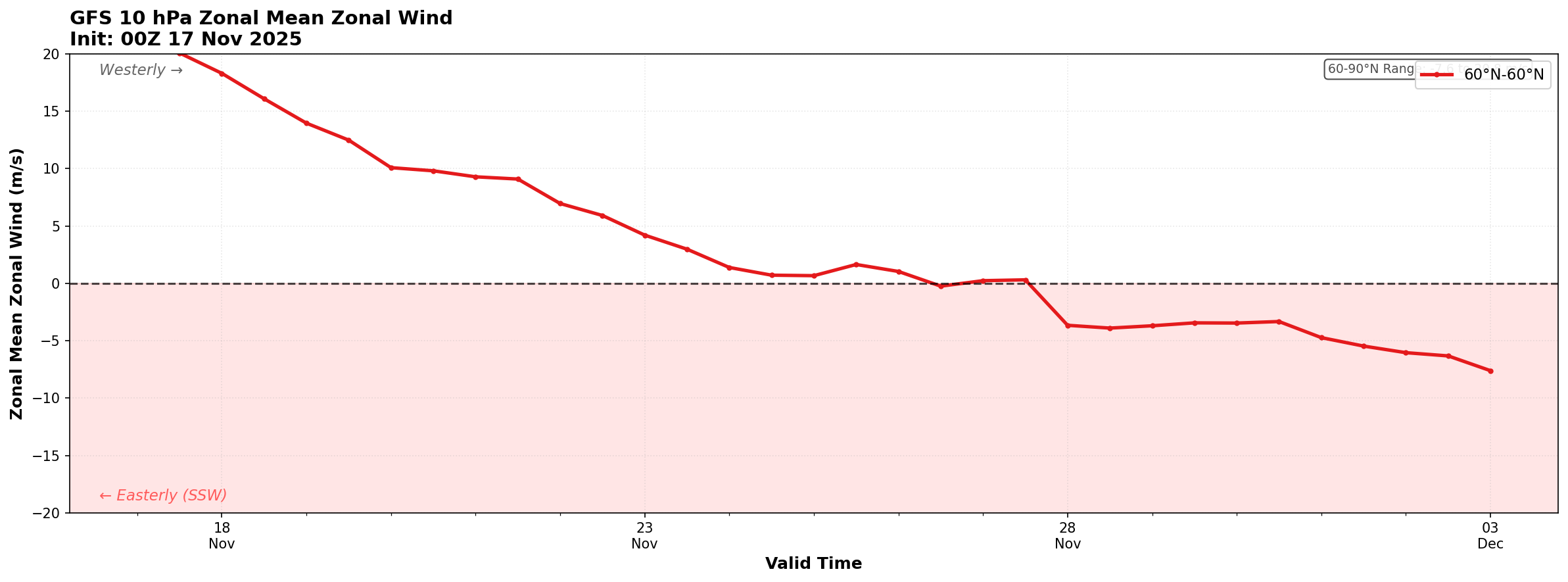
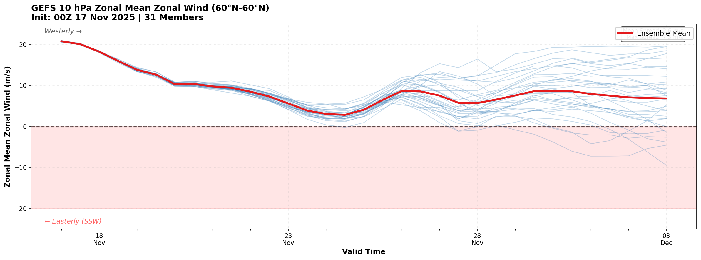
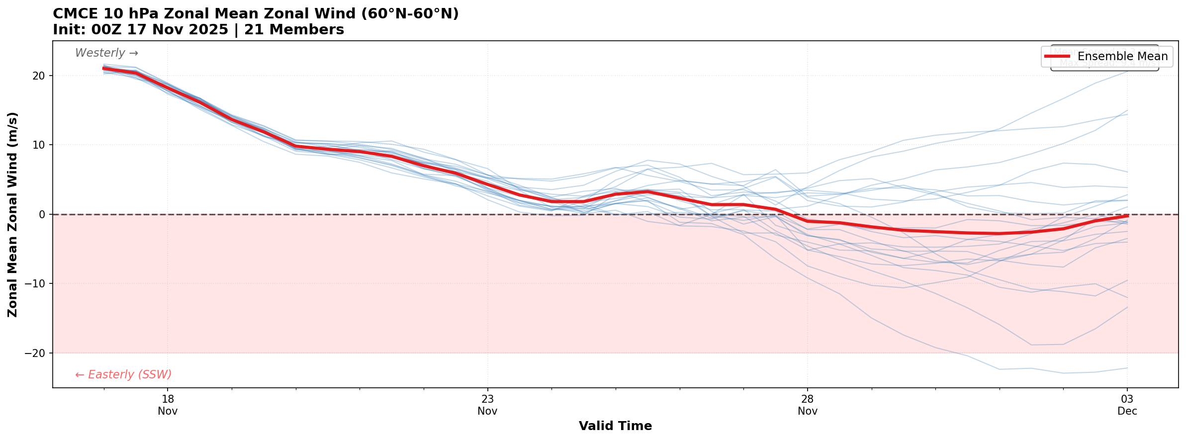
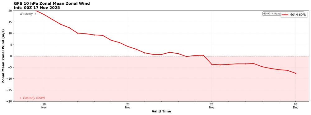
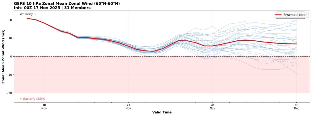
These aren't very polished, but for fun here is the GFS, GEFS, and CMCE 10 hPa zonal mean wind for the next 16 days. CMCE is on board with the SSW in the mean, GEFS is lagging.

-
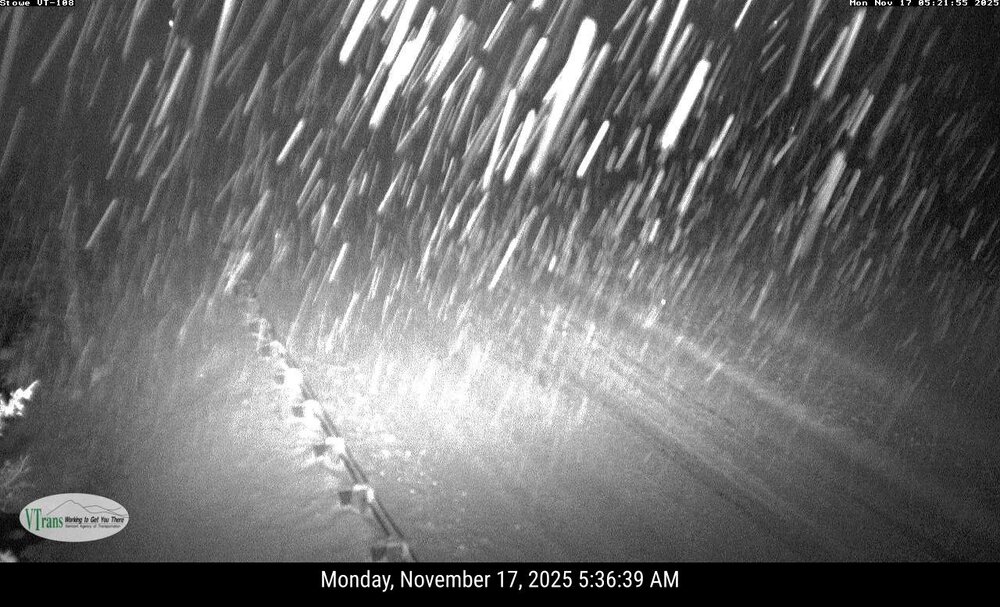
I wouldn't discount anything its ripping in Waterbury Center but determining any snowfall will be a challenge with this wind.
-
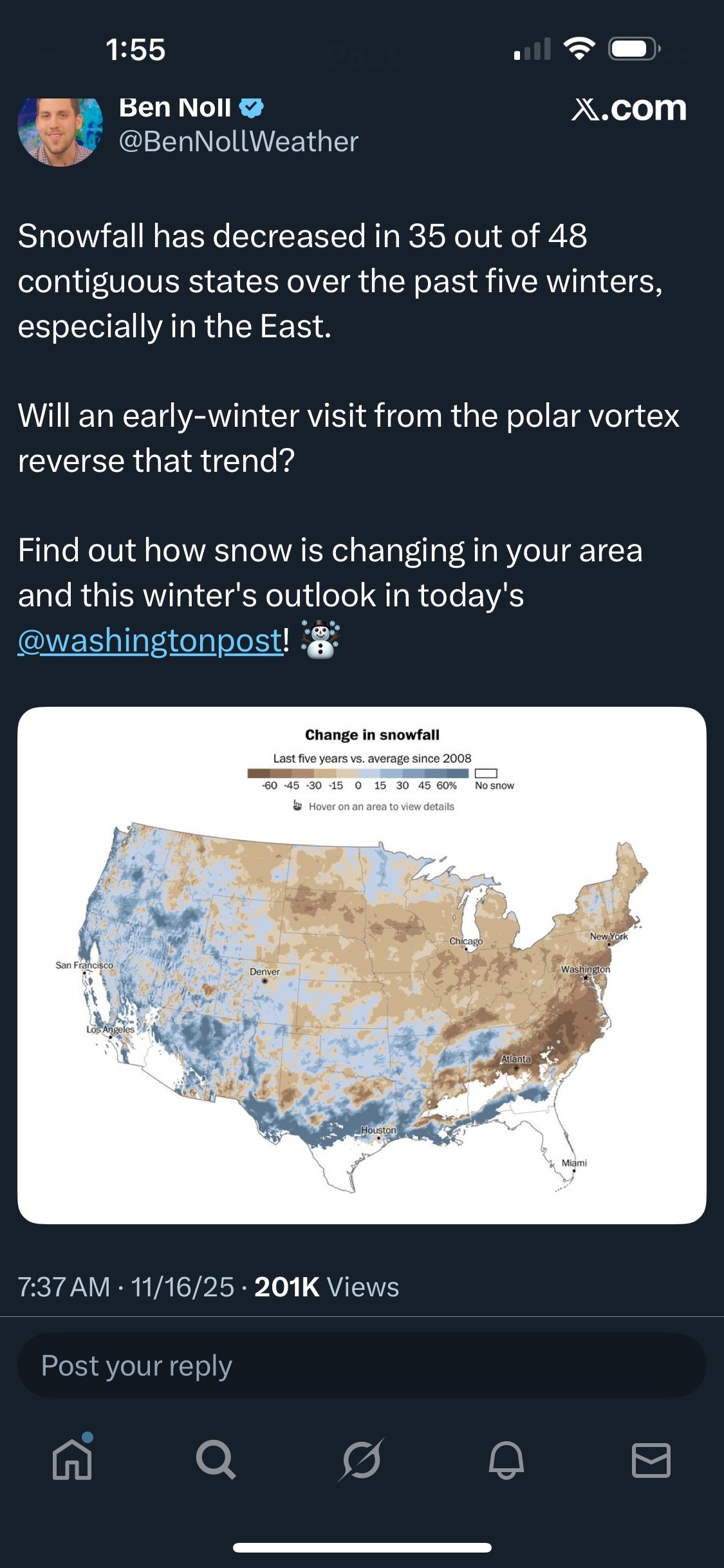
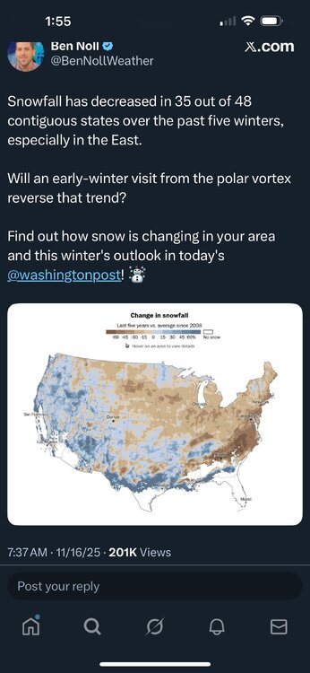
CoastalWx will get upset at me for posting the screenshot! LOL. But really, using just the last 5 years, and averages only since 2008? That is much too short of a time frame to determine any real trend either way. As I think I have mentioned before, New England suffered through a crappy snow period 1978-79 to 1991-1992. Yes there was some biggies, but largely confined to 1981-1984. It really was bad 1984-1985 to 1991-92. In Woburn MA, my biggest single snowfall during that latter period was only 11"! That seemed like a lot back then, but now, MEH unless at least 18" after epic 1992-93 to 2015-2016! CoastalWx has vivid "traumatic" memories as a li'l kid at the time in the mid-late 80s -- "WHERE'S MY 4-8" IN THE BACKLASH!!!"
-
You know WE GOT HIM, one of these days when I am REALLY bored, I just might try out the SESH. I might blast Ken Carson at 220 decibels while I participate.
-
DCA: 15.3" BWI: 17.7" IAD: 25.4" Dale City will get 22.5 inches snow this winter. RIC: 13.2" SBY: 15.1" Look guys I am super optimistic but I don't think the Nina is gonna agree with me so these are my prognostications.
-
Yeah it was for sure snowing… Lookout cam had picked up 4” today when I wrote that. Now up to 7” at 2am, ha. Didn’t mean for it to come off like it wasn’t snowing, but to get some of these gaudy amounts 18-24”+ thrown around, I would’ve liked to see a bit more earlier today. The nocturnal flow blocking has helped a lot, congealing into a more laminar classic band.