All Activity
- Past hour
-

Winter 25/26 General Obs
Holston_River_Rambler replied to Holston_River_Rambler's topic in Tennessee Valley
Interesting features to the lee of Black Mt. KY and High Knob, VA earlier this AM: -
-

Wednesday Feb 18 Mixed event. NoP refresher?
WxWatcher007 replied to HoarfrostHubb's topic in New England
This is incredibly narrow but somebody will get hit good. Won’t lie. I want the bullseye over WXW2. Hope y’all rain. -

Wednesday Feb 18 Mixed event. NoP refresher?
weatherwiz replied to HoarfrostHubb's topic in New England
I was thinking Wednesday that outside of wherever that narrow band of snow sets up probably consists of some very light periods of sleet or freezing drizzle but should be extremely low impact -
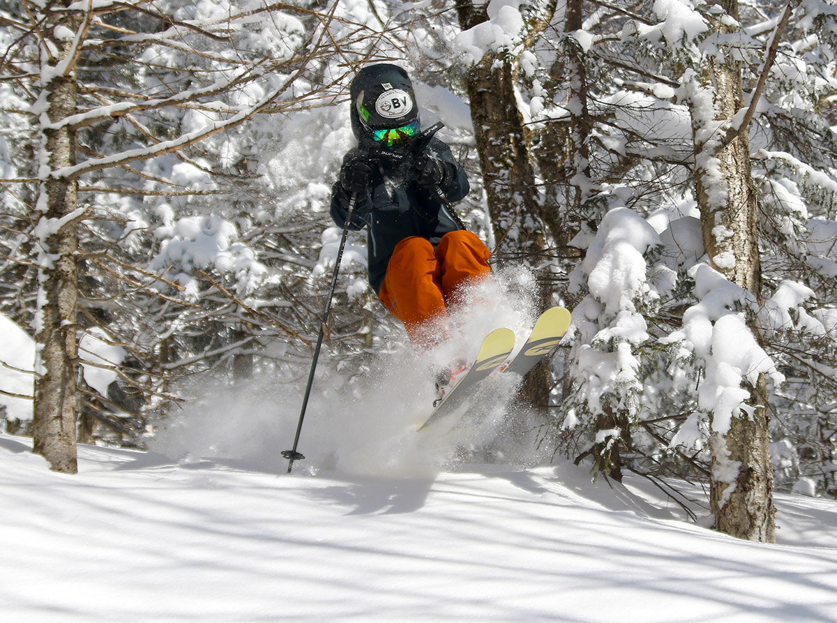
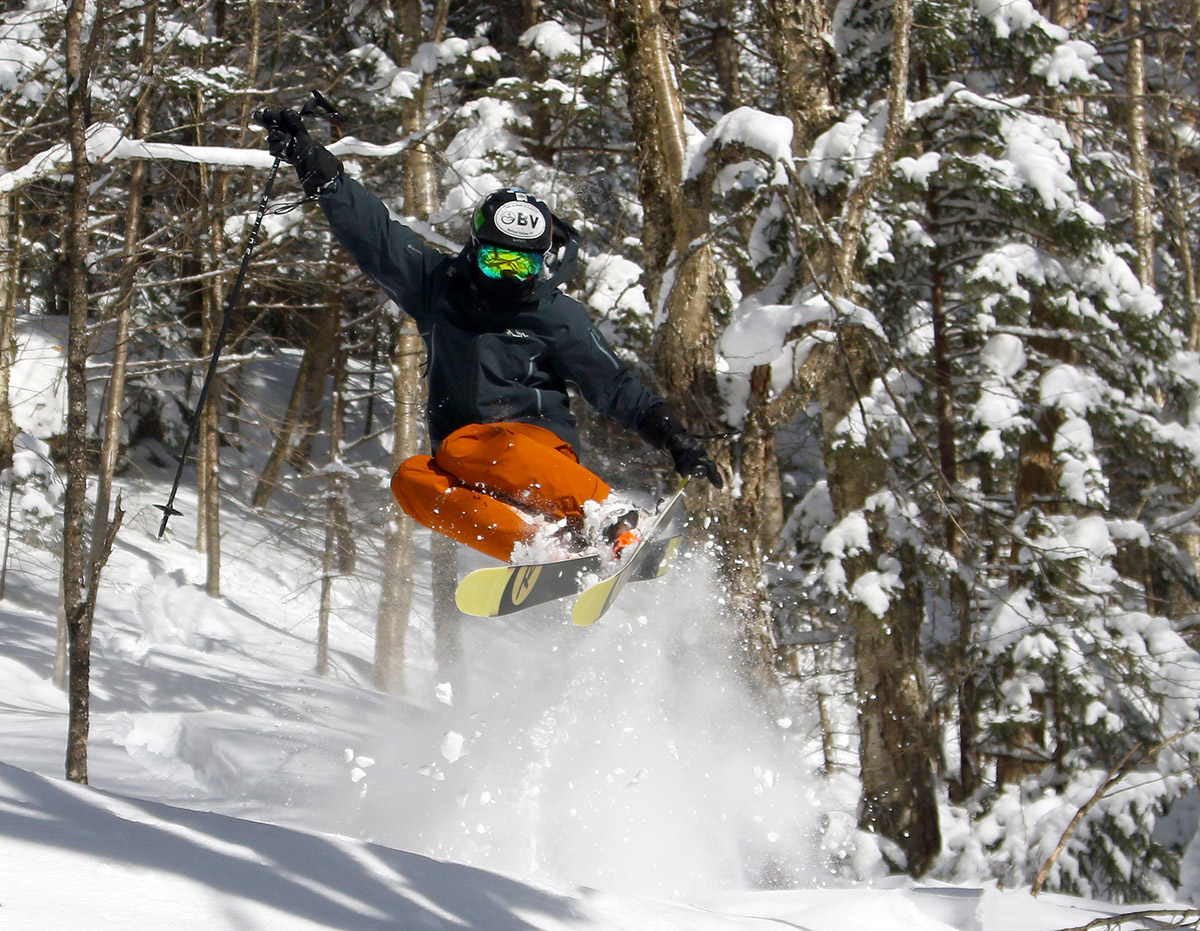
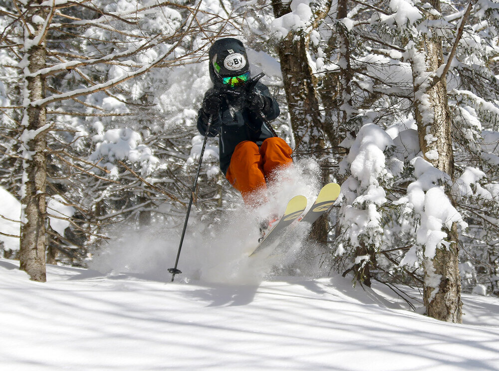
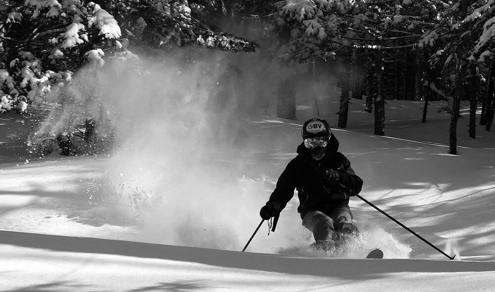
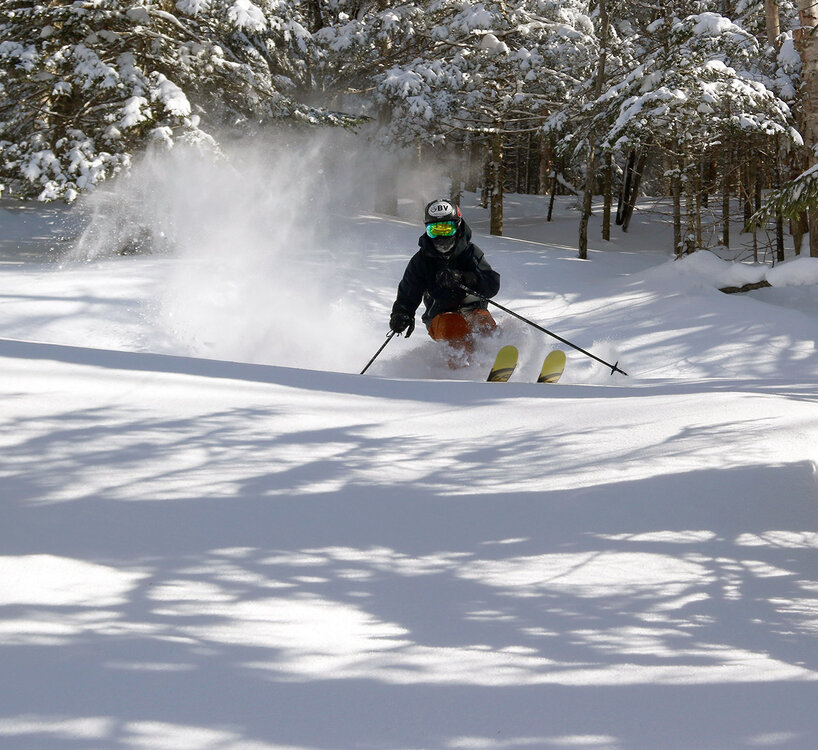
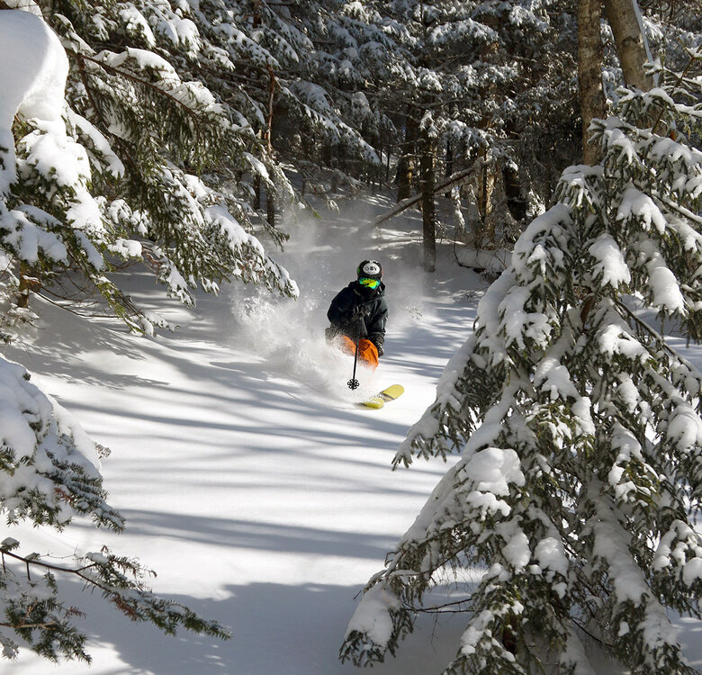
Our most recent storm brought some snow on Saturday into Sunday, with a couple more inches to top off the midwinter snowpack. It was nice to refresh the surfaces a little, but it certainly wasn’t enough to reset the powder brought by our previous system, which has been getting skied pretty thoroughly after several days and some holiday weekend skier traffic. Our midwinter temperatures have been preserving the snow quite well however, so my older son and I headed up yesterday for a lift-served session at Bolton Valley. We spent most of the outing working the sidecountry to get to fresh snow and did a lot of what my son likes to call “high octane” skiing. It’s not that it’s especially aggressive skiing, but it’s the term he uses for when he ventures into tightly forested spots that most people don’t visit, areas that can be a little more challenging to get through initially. They can still offer great skiing though if the powder is deep and allows your turns to fit the pacing of the tree spacing. And these less frequently visited areas with tighter trees often quickly drop you into areas of open forest that nobody has skied. And that’s how yesterday’s session evolved; we spent most of the first half of our time in the sidecountry on the north side of the resort and used the Wilderness Lift for access. Then we finished off by hitting some of the sidecountry on the south side of the resort that is serviced by the Timberline Quad. The snow has been staying light, dry and bottomless, so as long as you can get to untracked areas, you’re going to be rewarded with fantastic powder turns. On piste, the packed conditions are also quite good, but the snow is well packed at this point with holiday levels of skier traffic. Sunday seemed much busier than Saturday, and I bet that’s because it was a beautiful sunny day for most of it, and people really love to get out when you have seasonable temperatures and sun. Clouds did build in later in the afternoon ahead of the small system that is in the area today.

-

Wednesday Feb 18 Mixed event. NoP refresher?
ORH_wxman replied to HoarfrostHubb's topic in New England
Not much. This isn’t a huge inverted airmass oozing down…we might see a little more of that on the weekend threats but this one is mostly rain vs snow. Could be a very narrow area of IP and marginal ZR but we’re prob talking like 10-20 miles wide. -

Wednesday Feb 18 Mixed event. NoP refresher?
CT Valley Snowman replied to HoarfrostHubb's topic in New England
Hard to keep most of the sub forum happy with a set-up like this. We watch and we wait. I would still feel better NOP. -
Pic of the trees behind the house, looks like they are on fire, lol.
-
Oh, lol
-

Wednesday Feb 18 Mixed event. NoP refresher?
ineedsnow replied to HoarfrostHubb's topic in New England
RRFS coming south of 6z -

Wednesday Feb 18 Mixed event. NoP refresher?
Damage In Tolland replied to HoarfrostHubb's topic in New England
Thoughts on any sleet/zr? -
Wednesday Feb 18 Mixed event. NoP refresher?
ORH_wxman replied to HoarfrostHubb's topic in New England
Whatever happens on Wednesday, looks like advisory snow or better is in a pretty narrow band…something like 50-75 miles tops. -
1.1" from storm here, 30.6" for season (officially above normal), and today marks 1 month of straight snow cover. Not bad...
-
0.0
-
Wednesday Feb 18 Mixed event. NoP refresher?
ORH_wxman replied to HoarfrostHubb's topic in New England
Yep wrong thread but NAM looked like a loaded gun at 84h there. -

Wednesday Feb 18 Mixed event. NoP refresher?
dendrite replied to HoarfrostHubb's topic in New England
It’s weird. We were bashing it last week about last night’s system for the overphasing and then it caved south…only to have all of the models eventually phase a bit more and bring some light snow more northward. But yeah if everything is south before the euro comes out I think it has to come south too. -
a joke.
-
No what’s that?
-
This is a great data viz of the reservoirs and snowpack in California. They're still coasting on a series of good winters and the reservoirs started high.
-
I think peeps just recognizing that coastal development has been tenuous at best so buyer beware
-
Have you heard of the weekend EE rule
-
A little over an inch in Morristown and another wintry day. Solid winter but excited for the ice/snow pack to melt this week.
-
Why though? That’s bizarre
-

Central PA Winter 25/26 Discussion and Obs
mahantango#1 replied to MAG5035's topic in Upstate New York/Pennsylvania
Same amount of rain here .14 -

Wednesday Feb 18 Mixed event. NoP refresher?
SouthCoastMA replied to HoarfrostHubb's topic in New England
Nod to the AI and GFS.