All Activity
- Past hour
-
Science forum bro. I don't think a -EPO can't happen.. that's more possible than historical analog suggests, but +PNA has been really hard to come by in this peak decadal -PDO or whatever is going on.
-

2026-2027 Super El Nino
GaWx replied to Stormchaserchuck1's topic in Weather Forecasting and Discussion
Per The Long Paddock website, which hasn’t shown a new SOI daily since July 2nd: June/July SOI values have been subject to an incorrect data feed. The values will return after the data source has been replaced and values are recalculated. https://www.longpaddock.qld.gov.au/soi/ -
2026-2027 Super El Nino
GaWx replied to Stormchaserchuck1's topic in Weather Forecasting and Discussion
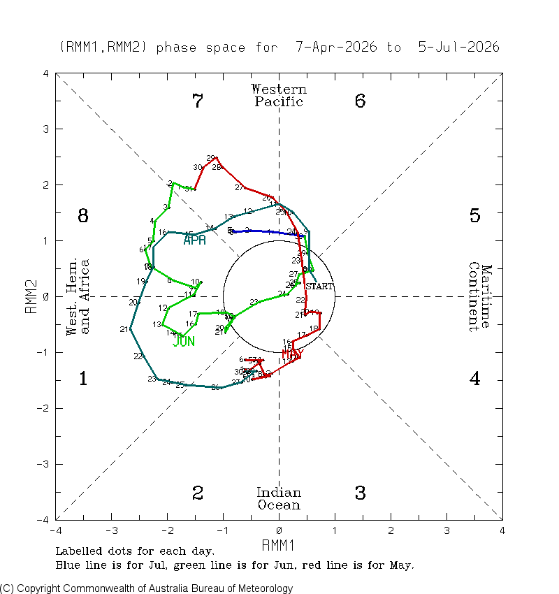
The strong left-sidedness of the MJO continues: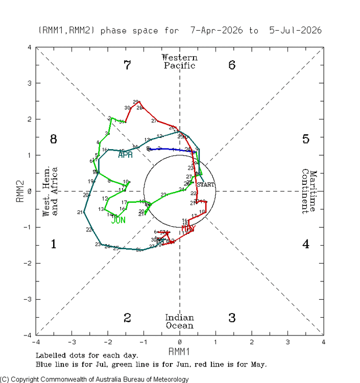
-

2026-2027 Super El Nino
so_whats_happening replied to Stormchaserchuck1's topic in Weather Forecasting and Discussion
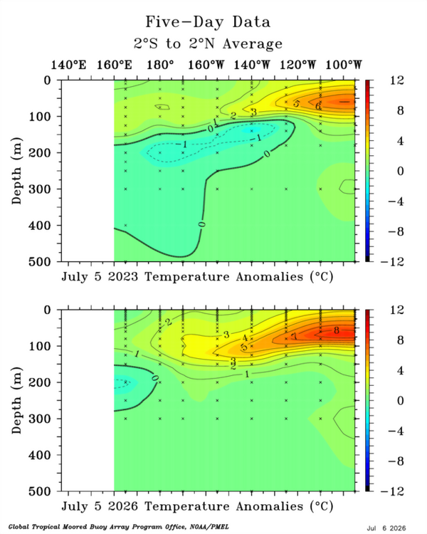
The difference in overall depth of the warm anomalies looks to be an artifact of the -PDO still being around. During the 2023-24 Nino this was centered around 130-140W. We also are lacking a significant negative anomaly region developing near the Dateline. I gotta ask the question though are we seeing Nino take on a new form with SSTs the way they are globally?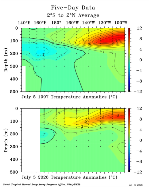
-
 Patricia's 872 mb was estimated. Recon timing was such we missed its absolute peak. One got 880 mb and the next 879 mb, but in between those (it was over 6 apart, maybe 12?), Patricia was still in RI mode, and then had slightly weakened a bit on satellite when recon measured 879 mb. So we know it was lower that 879 mb. 872 mb was decided on somewhat subjectively, but it easily could have been lower than that. I have noticed when it comes to world records, the WMO will avoid estimates as to the official record, and estimating a world record has it own logistical and social issues! Something similar occurred w/ Isabel in 2003. Its first recon was cancelled and it was the same day it peaked intensity. When the first recon got there the next day, Isabel had undergone an ERC and the eye diameter had almost doubled, yet they still found 920 mb / 140 kt. In the BT data, Isabel is listed as 915 mb / 145 kt the day before the recon, but given what we know about ERCs and how much the eye pressure typical rises in a cycle, I bet Isabel actually had a min pressure 900-905 mb! Then Isabel went on to be the best example of an annular hurricane in the Atlantic we have see since the satellite era began!
 -
2026-2027 Super El Nino
so_whats_happening replied to Stormchaserchuck1's topic in Weather Forecasting and Discussion
Im not going to play catch up since I have last been on here but here is TAO from May through July 4th, I'll be taking out May next update around mid month..thumb.gif.b6a5e787aef93ab1c7862c0e7be4773c.gif)
-
4.59 inches here.
-
Had to drain the pool twice today ,,,just did it again after I walked the dog,,,,and still raining here in New City
-
Apparently there are water rescue calls starting to appear in Manassas.
-
At 4.59 inches now in Highland Mills. Hopefully most of this hit the reservoirs.
-
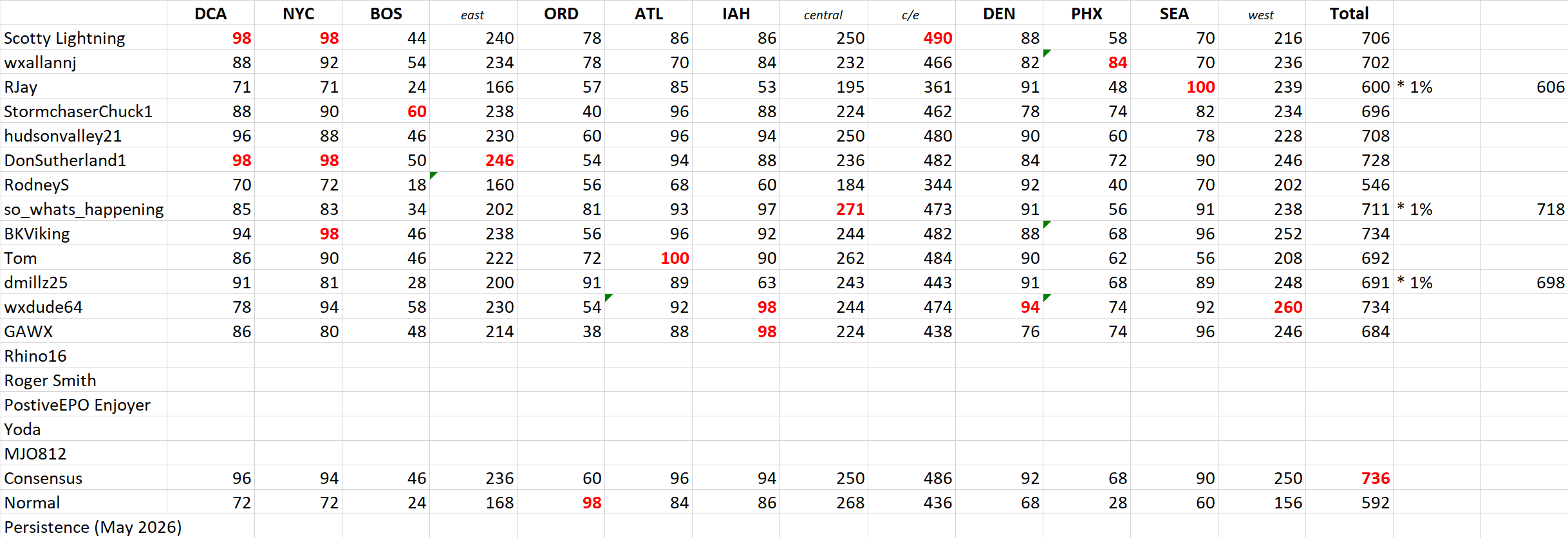
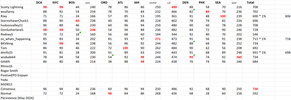
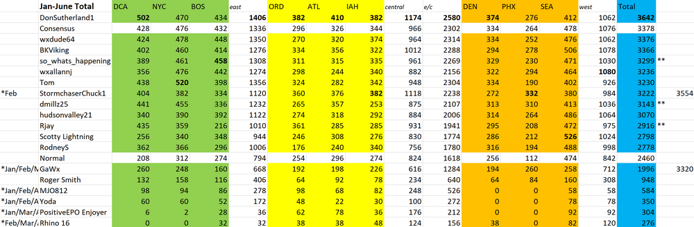
If anyone finds discrepancies in the numbers please let me know. For the deductions for June I picked 7 stations to knock down 1 point and 6 stations for RJay.
-
.37 today
-

Big Heat (and storms?) Week into July 4th Weekend
HokieEnginerd replied to yoda's topic in Mid Atlantic
Just west of there, but yeah. Hit 3 inches a few minutes ago and have had house shaking thunder for the better part of an hour. I haven't seen anything like this in a LONG time. -
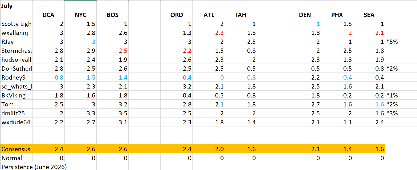
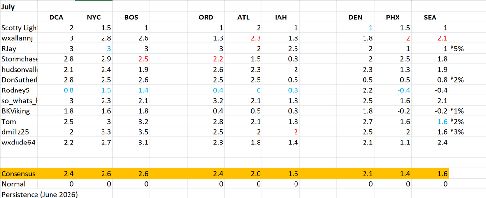
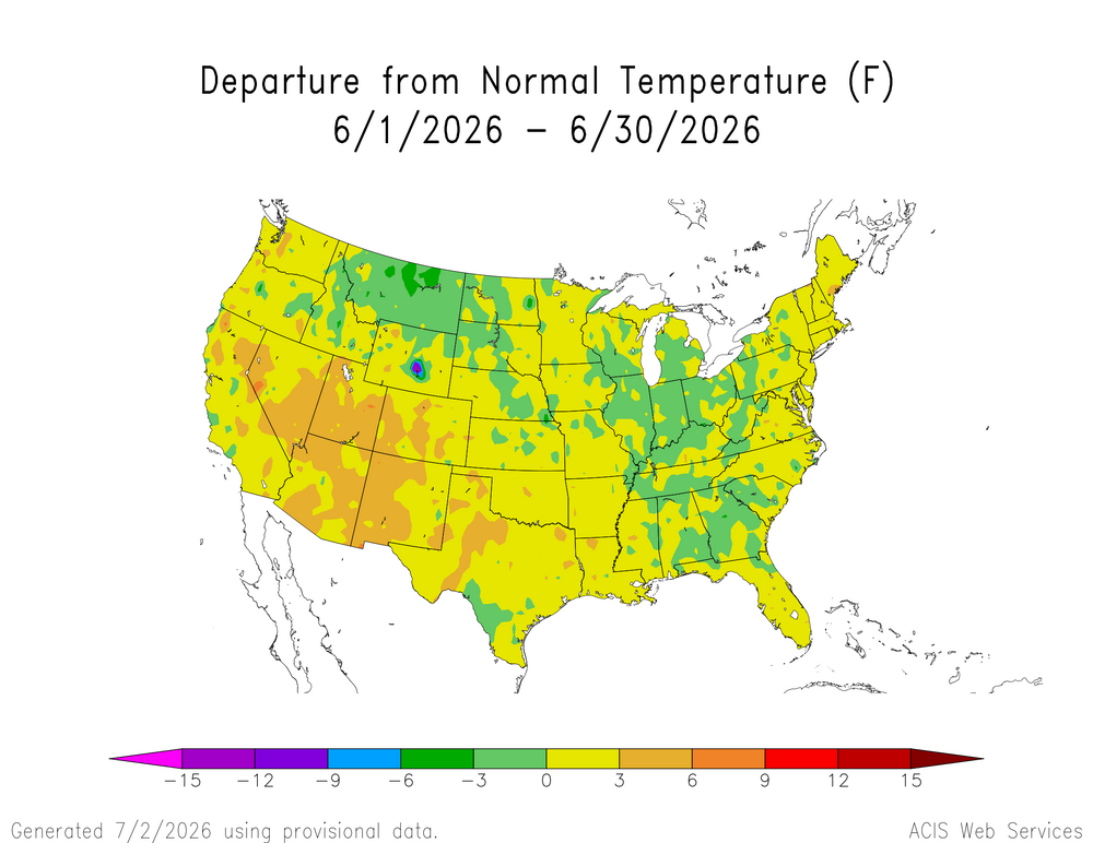
Im honestly debating on the late entries for this month (July) as it stands these are the forecasts and the what coinciding late entry percentages look like. Ill maul it over and if see if anyone else wants to chime in about it. Ill see if I can also do a quick update for max temps and where they stand thus far in a week or so.
-

Hoisting the Sultan Signal: Heavy Rain Event July 5-7
dendrite replied to WxWatcher007's topic in New England
Damn 5.47” for Shabbs -
yeah anyone near Manassas looks like they are getting hammered.
-
Finally some rain. Yay.
-
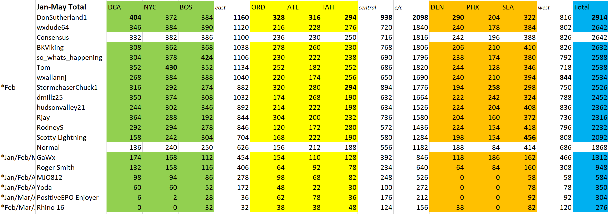
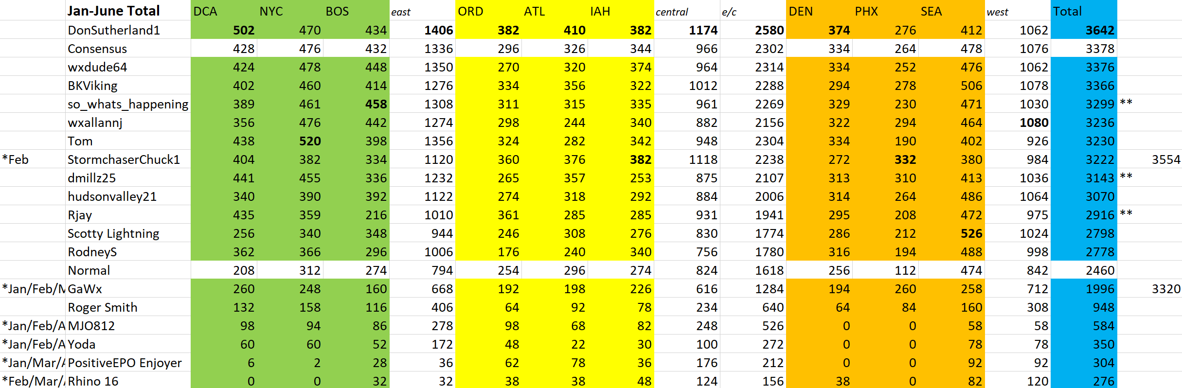
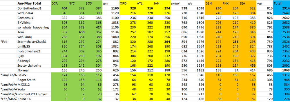
Ok sorry for the delay got back on the 4th and was bombarded by storms, lost power and internet. Then yesterday we had flash flooding still no power, hope it comes back tomorrow. We had very little movement in numbers. We had a few late entries and they are marked with * 1% for those affected most were 7 points off RJAY ended up only 6 points off the original total so not much of a difference. I included a consensus number to both GaWx and Stormchaserchuck for the months they were missing to get an idea if they had played through where they would stand in the far right column.
-
Have had several periods of that soaking type rain that feels tropical in nature throughout the day. Up to 1.5" now. Far below some other areas, but you can already see the life coming back to the vegetation and grass. This type of event is better for doing that than those brief torrential downpours from a cell.
- Today
-
Big Heat (and storms?) Week into July 4th Weekend
HokieEnginerd replied to yoda's topic in Mid Atlantic
I am right under the western side of that cell. We have gotten about 2 in in under and hour and it is still coming down. -
When they took that more S-N jog is when they really intensified. We have been getting much needed rain imby. Cold front sweeping though tonight might help with a bit more. .
-
At a time when most storms are ramping down, the cell near Manassas exploded, seemingly aided by a cell merger. Major downburst signal.
-
Chuck you must charge a ton to go to parties.
-
Received a whopping .06" from all the activity yesterday, followed by another .07" today. T&L all around but only a few occasional drops here. Congrats to all of those who are cashing in on the totals...
-
Big Heat (and storms?) Week into July 4th Weekend
HokieEnginerd replied to yoda's topic in Mid Atlantic
FINALLY getting some rain out here near Gainesville. First time it has been more than a few token drops all weekend. Got 1 in and it is still falling hard.




.gif.4e45cd1241a8aea0baf60fd74c1a9574.gif)