All Activity
- Past hour
-
33° First Frost
-
910 extrap
-
It's moving so slow that it may not matter-if it were moving at 10mph and suddenly lurched north then I can see what you're saying...
-

Spooky Season (October Disco Thread)
Damage In Tolland replied to Prismshine Productions's topic in New England
34.8 here . Grow on -
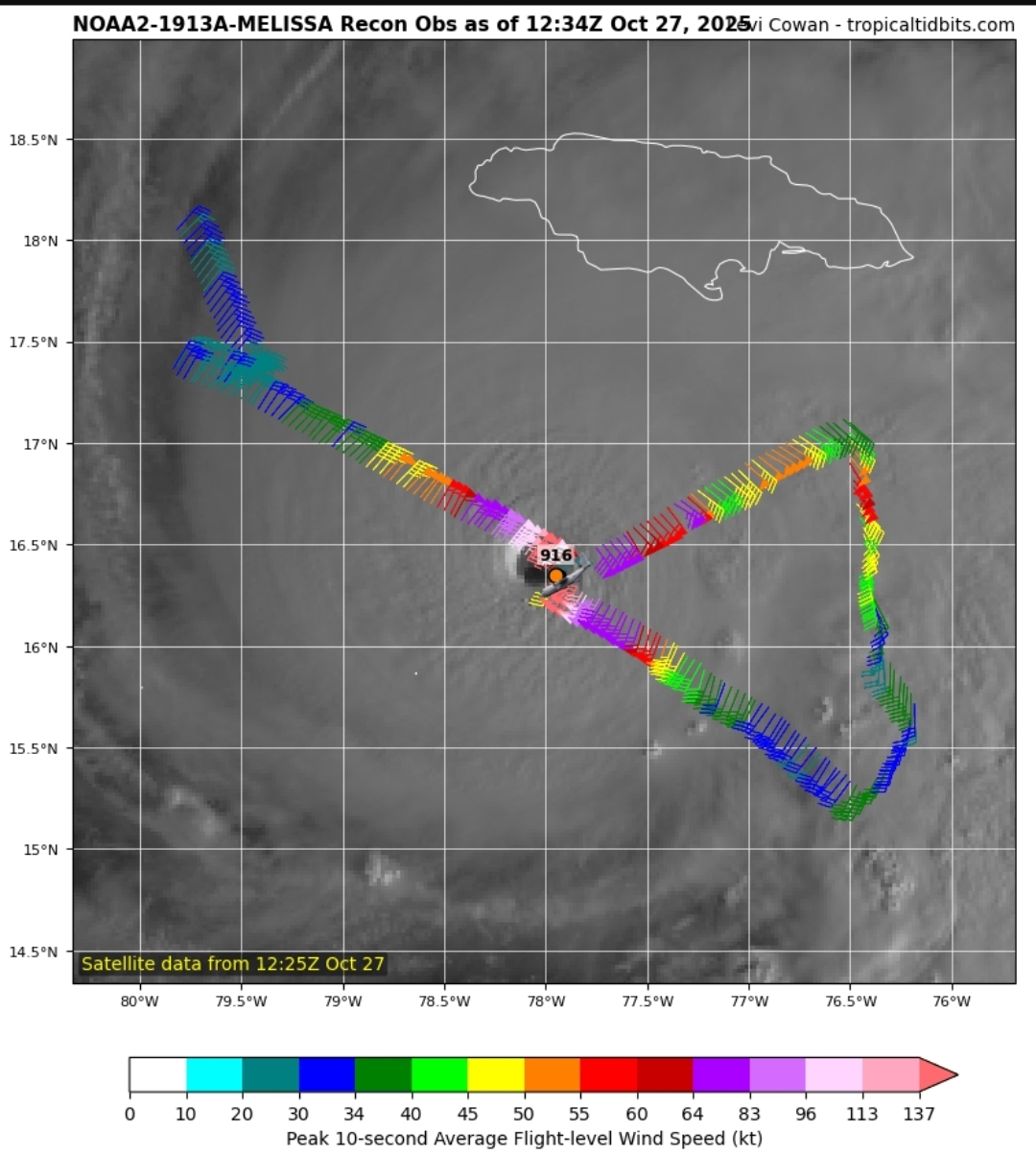
Recon may be positioning to make an east to west pass. I say that because their current flight path would miss the eye unless they turn due west. Nevermind. I don't know what I was looking at there. It is still a NE to SW pass.
-
Have we ever seen a cat 5 hurricane make a massive change in direction while maintaining strength?
-
It just depends on forward motion, it isn't basin specific. When Melissa starts moving NE, the strong side will be the SE side.
-
If an ERC happens soon, it could mean much worse impacts over bigger areas. Right now the storm is really small. If it turned north right now, eastern Jamaica wouldn't even get hurricane force winds and surge would be minimal outside of the small core.

-

Was Winter 2024-2025 one of the Coldest Winters on Record for BWI
IronTy replied to MDScienceTeacher's topic in Mid Atlantic
It's been so long since we had a cold winter that even an average winter feels like an ice age. -
I am using the term early season to describe the activity prior to what is considered the late August into early September traditional peak we used to get more often. Erin went Cat 5 on August 16th. The record SSTs are why we haven’t had any really low ACE seasons since 2013 and 2014. This lead some to speculate that the AMO was going to shift colder back then. But instead the Atlantic SSTs reached all warmth over the last decade with the historic run of Cat 4-5 systems.
-

Central PA Fall Discussions and Obs
mahantango#1 replied to ChescoWx's topic in Upstate New York/Pennsylvania
LONG TERM /WEDNESDAY THROUGH SUNDAY/... Confidence continues to increase in a widespread, soaking rainfall from late Wednesday through Thursday. Surface low pressure will track northward into Pennsylvania as its parent upper trough interacts with an upper low to our northeast, pulling a plume of moisture into Pennsylvania from the Atlantic. The trough becomes negatively tilted as it approaches the region, which should center the strongest synoptic scale forcing right over Central PA Wednesday night into Thursday morning. NBM QPF ranges from right around an inch over northwestern PA, to an inch and a half for areas east of I-99 and south of I-80. It is worth noting that there are still quite a few ensemble members that suggest portions of south-central PA could see upwards of 2 inches of rain. WPC has expanded the marginal risk of excessive rainfall to include all of Central Pennsylvania, but with the drier than normal conditions over the past few weeks, the rainfall should largely be beneficial. In addition to the rainfall, winds will be gusty on Thursday with a fairly tight pressure gradient around the low. Winds gusts of 20 to 30 mph are expected, with some gusts to 35 mph possible in the higher terrain of the Alleghenies. While there are still some timing differences in the models, expect rainfall to gradually taper off late Thursday into early Friday as the low begins to move off to the north. Lake effect and upslope rain showers will continue through the weekend as upper troughing remains in place over the northeastern United States. High temperatures through the weekend will remain near to slightly below normal, generally ranging from the upper 40s to the mid to upper 50s. Lows will be in the 30s and 40s. -

Was Winter 2024-2025 one of the Coldest Winters on Record for BWI
bncho replied to MDScienceTeacher's topic in Mid Atlantic
Was Winter 2024-2025 one of the Coldest Winters on Record for BWI? fuck no -

2025-2026 ENSO
PhiEaglesfan712 replied to 40/70 Benchmark's topic in Weather Forecasting and Discussion
We didn't get the early start to the season this year. The season was quiet until mid August this year, and was pretty much a one-off (with Erin) until Gabrielle. -

Spooky Season (October Disco Thread)
Cold Miser replied to Prismshine Productions's topic in New England
It's coming. -
Yeah, that was an amazing late season snowfall pattern. Islip had 36.5” of snow from 3-7-18 to 4-2-18. But Islip has only had a total of 27.6” during 22-23, 23-24, and 24-25.
-

2025-2026 Fall/Winter Mountain Thread
Maggie Valley Steve replied to Buckethead's topic in Southeastern States
42 and rain this morning. It's going to be an interesting week weather wise. Thursday night into Friday morning we should be under the influence of a potent cold core upper low. Temperatures look marginal at this range, but surprises often occur in a transitioning pattern. I continue to see additional changes towards a colder regime and periods of unsettled weather. Oh, and they have started making a snow mound at Tube World last week. Tis the season! -

E PA/NJ/DE Autumn 2025 Obs/Discussion
Birds~69 replied to PhiEaglesfan712's topic in Philadelphia Region
Wouldn't be a bit surprised if some of the colder spots were in the 20s... -
One of the easier miss steps to make. Stay well, as always ……

-
Yeah especially in these downpours. They've canceled work for us today so going back home myself.
-

Spooky Season (October Disco Thread)
Spanks45 replied to Prismshine Productions's topic in New England
24.6 this morning, what maples haven't lost their leaves are dropping them steadily this morning..... -
Low of 21 in Walpack. Low 28 at home in Sparta. Chilly morning.
-

Was Winter 2024-2025 one of the Coldest Winters on Record for BWI
WVclimo replied to MDScienceTeacher's topic in Mid Atlantic
1985 had a historic cold snap in January, but overall the winter wasn’t all that cold. December 1984 was very mild, on the order of +5 for the month. And the second half of February was also “warm.” Neither season was close to the coldest on record. -
 This is actual rage bait I’m impressed.
 -
 No, it was slightly below normal but nothing special. It was not colder than 2014-2015 or 2013-2014. They haven't updated the Winter column for 24-25, but you can do your own math: https://www.weather.gov/media/lwx/climate/bwitemps.pdf
 -
Records: Highs: EWR: 81 (1963) NYC: 82 (1963) LGA: 79 (1963) JFK: 78 (1963) Lows: EWR: 27 (1936) NYC: 28 (1936) LGA: 33 (1976) JFK: 31 (1976) Historical: 1764 - A "very remarkable storm of snow with high winds" produced 22 inches at Rutland in central Massachusetts. (David Ludlum) 1929 - A snowstorm dumped 27 inches upon Ishpeming, MI, in 24 hours to establish a state record. (David Ludlum) 1943: Coastal storm ends drought, rains on 25th - 28th DC had 3.41 inches of rain and Baltimore got 5.00 inches. (Ref. Wilson Wx. History) 1962 - An early season winter storm over New England blanketed northern Maine with 7 to 16 inches of snow, and southeastern New England with up to 3 inches of snow. Worcester MA received a record 4.7 inches of snow. (The Weather Channel) The low temperature of 21 °F is the lowest temperature ever recorded in Richmond in October. (Ref. Richmond Weather Records) 1987 - Showers and thunderstorms produced locally heavy rain from Virginia to New York State. Fallen leaves made roads and sidewalks slick, and also clogged sewers. Rainfall totals of 1.55 inches at Newark NJ, 1.54 inches at Harrisburg PA, 1.27 inches at Scranton PA, and 1.22 inches at Atlantic City NJ, were records for the date. (The National Weather Summary) 1988 - Low pressure brought snow and gale force winds to the Great Lakes Region, and snow and high winds to the north central U.S. Winds gusted to 47 mph at Lansing MI, and reached 55 mph at Pierre SD. (The National Weather Summary) (Storm Data) 1989 - Wintry weather invaded the northwestern U.S. A storm crossing the Central Rockies produced up to 23 inches of snow in the mountains east of Salt Lake City UT. "Indian Summer" continued in the Lower Ohio Valley and the Upper Great Lakes Region. Afternoon highs of 71 degrees at Marquette MI and 72 degrees at Sault Ste Marie MI were records for the date. (The National Weather Summary) (Storm Data) 1996: Thousands of homes in southern and central Texas were without power after strong storms dumped as much as a foot of rain. The Frio, Guadalupe, and Llano rivers spilled their banks, making roads impassable and stranding some motorists. The Llano crested at 30 feet -- 18 feet above flood stage -- and Llano County sheriff's deputies were evacuating homes downriver. (Ref. AccWeather Weather History) 2003: A strong cold front moved through the Mid-Atlantic during the afternoon, causing an outbreak of severe weather. An F0 tornado touched down in Hainesport, NJ, killing one person. This was the first tornado fatality in Burlington County, NJ history both in modern tornado records kept since 1950, and in reliable unofficial records extending back into the 1700s. The tornado cut a path 1/2 mile long and 30 yards wide. Although the tornado was F0, it is considered a significant tornado, usually F2 or greater, because of the fatality. (Ref. Wilson Wx. History) 2006: An F1 tornado (waterspout) came ashore and caused significant damage on the west side of Apalachicola Florida. 2006: An F1 tornado (waterspout) came ashore and caused significant damage on the west side of Apalachicola Florida. Marine boats sank, four homes destroyed, and part of a hospital roof collapsed. Hundreds of trees and power lines were down, but fortunately there were no serious injuries. (Weather Guide Calendar with Phenomenal Weather Events 2007 Accord Publishing, USA)