
All Activity
- Past hour
-

2026-2027 Record-breaking El Nino
Terpeast replied to Stormchaserchuck1's topic in Weather Forecasting and Discussion
It looks like the strong +AO pushed the mid-high lat ridges further south -
.thumb.png.8313b3b0e15f864f0e00f1af8ef93df7.png)
-
Interesting! I knew it'd be close to the average, I was thinking a little closer though. I figured the past 10 days would have cancelled out the first 10 days. I guess it kinda did.... Blaming September's relatively warm nights for this one.
-
17.4 (1983) Going back all the way to 1851, only 3 had lower ACE than 1983 and all of them could have been higher in reality due to being way before the satellite era: 1914, 1925, 1907 https://en.wikipedia.org/wiki/Accumulated_cyclone_energy
-
 cheap viagra and sildenafil online Buy generic 100mg Viagra online http://cloud.poodll.com/filter/poodll/ext/iframeplayer.php?url=https://sildendirect.shop Cheap Sildenafil 100mgand https://4k-porn-video.com/user/ekbuutuudw/ Cheap generic Viagra [url=https://www.google.se/url?q=https://sildendirect.shop]Order Viagra 50 mg online[/url] sildenafil 50 mg priceand [url=http://www.1gmoli.com/home.php?mod=space&uid=1126524]Viagra tablet online[/url] Cheapest Sildenafil online
 -
Slowly getting there...
-
The EC-AIFS has the best verification of the 5H pattern of any model right now. Precipitation coverage is good, but magnitude is too light within convective schemes. It is actually solid with handling more synoptic-based, stratiform-centric precipitation magnitudes. That's one of the reasons WPC uses it a lot in their model blends. It would be a disservice not to. ML guidance is the new wave inside 72 hrs right now, but you really have to utilize a good blend to get the best result for QPF distribution.
-
That's averaging 4.57"/month. Projected over 12 months, it's nearly 55". I'd guess that's a bit AN; 45-50 seems more likely. My average here is currently 48.6". Foggy 50 has turned to blue sky 60s.
-
Cansips is looking diesel. Does anybody know why it has that stubborn small blob of AN temps right over the Chesapeake for the winter? It's been there for a number of runs now. Is it something to do with bay water temps that it's picking up on?
-
I ended up getting only ~2.55” of rainfall in Sept, which is well below the longterm average of >4.5”. The upcoming progged significant rainfall in early Oct here would be most welcomed!
-
I was going to say, I haven't seen this much activity non Winter since 2005 lol
-
I know 1914 has lowest ACE on record. I consider anything not in the satellite era questionable. In the satellite era what season has lowest ACE?
-
Thankfully you can drive 9 hours to 300" of snowfall a Winter, or a few hours to the mountains.
-
Breaks in the clouds now https://synoptic.envsci.rutgers.edu/satellite/img/vis_nj_anim.gif
-
Don’t sleep on the Union. 12 game unbeaten streak since the World Cup. They’ve gone from last place to solidly in a playoff spot.
-
 Maybe we'll get a surprise -nao for the Winter. It's felt cool lately, in Sept I had 3 straight nights in the 40s and an early end to Summer locally for the 3rd straight year. I keep saying, hard to believe it can't cool down 30 more degrees for the Winter. The last 2 years had these late Summer/Sept patterns too, and they got cold for the Winter. With the east-based Nino/-PDO completely unfavorable for cold, I keep thinking where would it come from? Maybe the NAO?
 -
Heading to the Adirondacks tonight and tomorrow...Expecting foliage to be approaching peak in some spots.
-

Septorcher 2026 Discussion - Endless Summer
tamarack replied to Damage In Tolland's topic in New England
September numbers Avg max: 65.1 -2.7 Warmest, 74 on the 10th. That's our lowest monthly Sept max; previous was 76 in multiple Septs. Avg. min: 45.3 -0.5 Coolest, 30 on the 24th Mean: 53.2 -1.6 Coolest Sept since 2019. Precip: 3.06" -0.61" Wettest day, 0.99" on the 28th. The long-duration storm on 27-29 totaled 1.75". Other than the above storm, September was an unremarkable month. No strong wind, no thunder, no real heat, no real drama. The precip deficit since the end of June had brought the Sandy River down to the lowest 5% of its records for September 26th, data since 1929, and the 1.75" barely moved the flow to the 25th percentile. That said, fall colors came about a week earlier than average and the reds are as good as it gets. Other colors, yellows and the maroon ash, are good as well. -
In Minnesota too. Should be a blowout.
-

Brownsville Experiences Hottest September on Record
GaWx replied to donsutherland1's topic in Climate Change
Tulsa, OK, was 84.3 F in Sep ‘26, which was in addition to being 10.1 warmer than the longterm Sep mean: - 2.4 warmer than its 2nd warmest Sep - 1.4 warmer than its longterm mean for July - warmer than 69% of Julys, 74% of Augusts, and 98% of Junes on record (records back to 1905) @donsutherland1- 1 reply
-
- 1
-

-
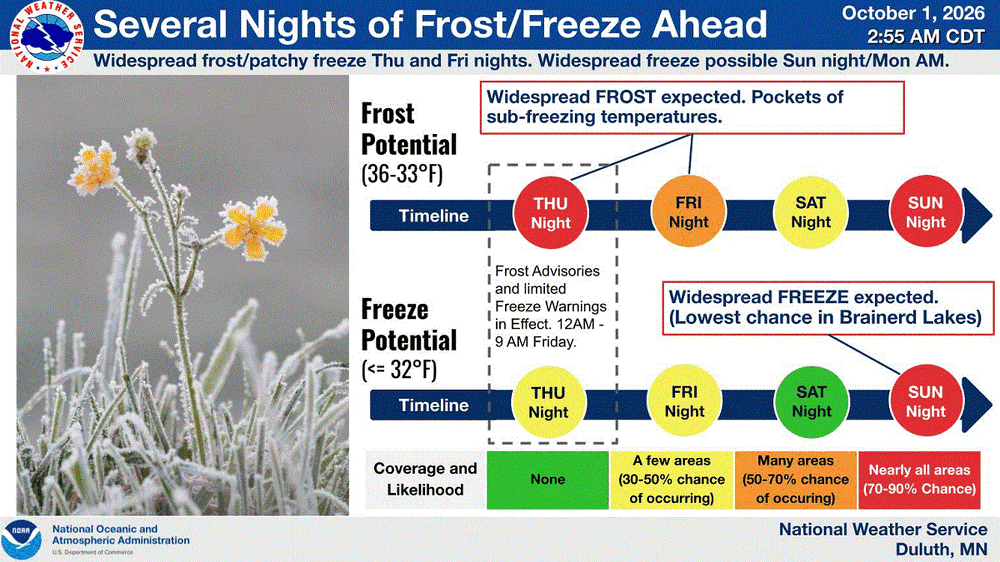
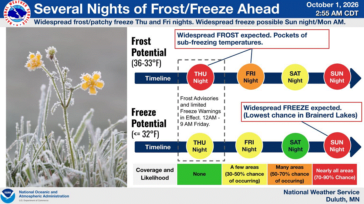
Looks like a stretch of frost/freeze potential coming up. DLH will stop issuing these at some point as growing season is over.
-
Enjoy it for now. It's gone after tomorrow.
-
the NAM3K jumped on board with the euro
-
Yeah we are going to lose December. The question is what happens after that.
-
Practicing for winter. Ukie ensembles.
.thumb.png.503c36054cefda03dec952fa4682fbf3.png)

.png.c3c43fd5bd251f3e0035a469c1e69d4c.png)














.png.887411a68da35e719b6f7e3cb0e799bb.png)