All Activity
- Past hour
-
Yes we know. The gfs is wrong
-
@aldie 22 so you are content with this outcome.. I'm hoping for a little better in your yard.
-

January 2026 regional war/obs/disco thread
jbenedet replied to Baroclinic Zone's topic in New England
I could easily see the 18th split the forum like the 12z GFS advertised… But at least we’re looking at legit big storm potential. The synoptic setup is amped. Finally something to track. -
Canadian 12Z run is completely different next weekend to from the GFS
-

2025-2026 Fall/Winter Mountain Thread
Buckethead replied to Buckethead's topic in Southeastern States
Moderate snow now in Wolf. Sent from my SM-S908U using Tapatalk -
We tried to tell em. We’re onto late January
-

Central PA Winter 25/26 Discussion and Obs
Blizzard of 93 replied to MAG5035's topic in Upstate New York/Pennsylvania
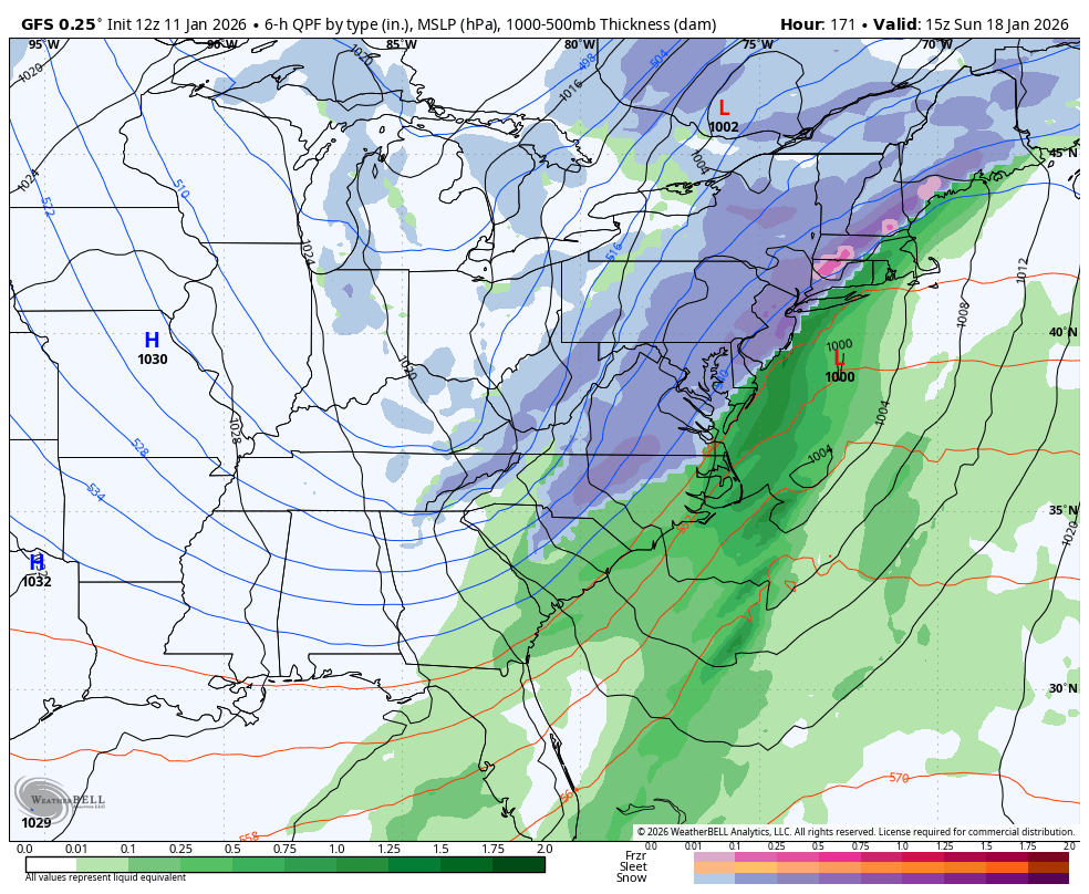
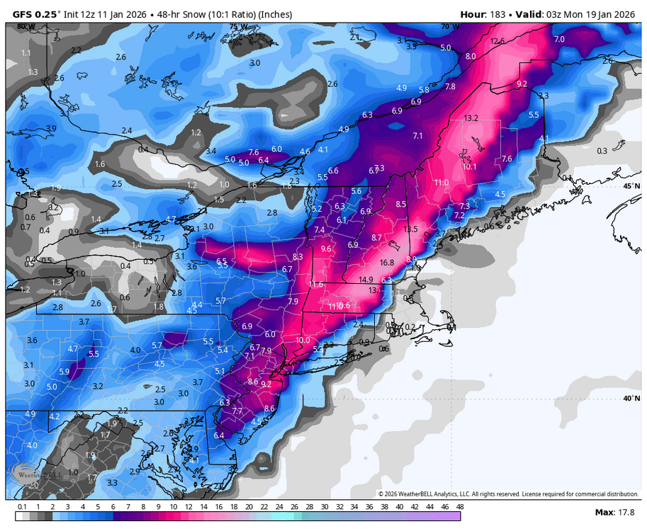
12z GFS combined snow through Sunday night.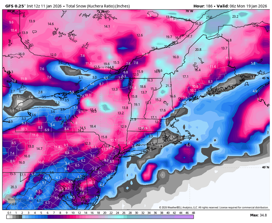
-

Central PA Winter 25/26 Discussion and Obs
Itstrainingtime replied to MAG5035's topic in Upstate New York/Pennsylvania
Sunday is alive as well. My thought on this right now? Thursday seems like a decent chance to get "some" snow. Sunday seems like perhaps a bit smaller chance but comes with potentially a bigger upside. -
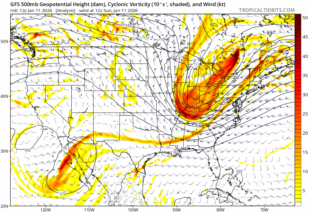
Not quite there yet maybe, but is the time we say, “The vort is not yet been sampled correctly it’s still not in range”.
-
FWIW, I do think the a coastal w/ the 17th front is plausible. I think the cold front driven snow is plausible provided the GFS drop the crazy PAC storm feed. So, I do think a front w/ a wave turning into a significant EC storm is very plausible.
-
Central PA Winter 25/26 Discussion and Obs
Blizzard of 93 replied to MAG5035's topic in Upstate New York/Pennsylvania
12z GFS is back this run for the Sunday chance with another CTP Advisory level event with heavier amounts to our east. Snow map is Only for the Sunday period.
-
Purty active pattern upcoming,someone should get something out of this mess

-
(002).thumb.png.6e3d9d46bca5fe41aab7a74871dd8af8.png)
E PA/NJ/DE Winter 2025-26 Obs/Discussion
ChescoWx replied to LVblizzard's topic in Philadelphia Region
The GFS with it's 1 - 2 punch for our next model snow event. Model snow we will never have to shovel -
Bonus for holiday weekend snow!
-
I was told I had no choice by the man who runs this insane asylum.
-
too warm that system but it's nice to look at
-
I highly doubt there is precedent for Pacific tropical features (during mid January) feeding into a cold front over our area along the EC of North America. Webber mentioned yesterday(finally remembered my source) that it was a pretty awful job by the GFS. Maybe late fall that could happen? No other model has that. I think it is a pretty massive GFS error. In fact, the 12z GEM provides no support for either the 15th or 17th (GFS solution) whatsoever. I think the GFS has a pretty signifiant bias right now at over-amping everything at times. However, it can sniff out weather systems like this, because of that bias. For now though, I have the GFS as an outlier and at a level where it almost has to be tossed, but let's see if the Euro has something. What is plausible is a cold front tapping the Gulf, and I won't rule that out with the 17th system. Conversely, the GEM looks suspiciously anemic, and that would be a red flag for that model. A strong cold front w/ short waves in tow...should have some dynamics. The truth is probably somewhere in between the GEM and GFS at 12z.
-
GEFS for storm 1 looks to be continuing the trend to the op. Hope the stubbornly low snow means can come up a bit.
-

Winter 2025-26 Medium/Long Range Discussion
mimillman replied to michsnowfreak's topic in Lakes/Ohio Valley
So is this a legit LE signal? -

January 2026 regional war/obs/disco thread
CoastalWx replied to Baroclinic Zone's topic in New England
Hopefully find some thin ice to fall into. -
Would like to see a little more dig/sharpness here, and a tad bit negative with the orientation. Plenty of time with this one.
-
Gfs is a big hit a week from now. Starts as rain and goes over to heavy snow.
-

January 2026 Medium/Long Range Discussion
SomeguyfromTakomaPark replied to snowfan's topic in Mid Atlantic
I agree with @stormtracker that an area wide 3-5 would be better than this narrow nonsense, but we have to take what we can get! Just happy it trended in our sub forum at all though. -
Are you crazy!? Shhhhhhh
-

January 2026 regional war/obs/disco thread
dendrite replied to Baroclinic Zone's topic in New England
Trip to CH with MassWx that run