All Activity
- Past hour
-
Ugh, running away from each other…
-
Yeah we just have to hope that the cold air which returns around 1/14 can set up some semblance of a wintry pattern. We thawed very well over the past week and a return to colder weather would ideally bring some chances for winter weather but we've seen stranger things happen at this point
-

2025-2026 ENSO
donsutherland1 replied to 40/70 Benchmark's topic in Weather Forecasting and Discussion
Amidst all the discussion of a possible strong WWB this month, the development of a pretty strong EWB slipped under the radar. In fact, the past two days have seen the SOI at or above +20. Interestingly enough, a slightly weaker EWB (just below +20) preceded the record-January WWB of 2017 by about a week. -
My contribution for today. Not many changes at hr 30 on the 12z GFS.
-
Plenty of sustained cold. Many will be below normal for next week. We live in the subtropics….it wants to snow here for about 4 weeks a year. Always important to remember. Plenty still to track. And it’s almost always thread the needle at this latitude. When we get crazy cold, it usually goes dry. We want to be right on the gradient for a chance at big snows.
-

2025-2026 Fall/Winter Mountain Thread
Maggie Valley Steve replied to Buckethead's topic in Southeastern States
Light snow in the Valley and roaring wind at times. -
lol
-
Lot's of energy expended last few days on this upcoming non event. It never had any kind of remote support from ANY ensemble guidance and the best modeling we have (ECMWF) never had much of anything. GFS is a follower not a leader. Without some kind of steady multi cycle support from at least the CMC or better yet the EURO best to ignore it. In my opinion the GFS will never be the first to sniff anything out 3-5+ days in advance. MAYBE if it has some ensemble support from its own members it might deserve some attention otherwise I ignore it. For now I'm more interested in the return to colder starting later next week and beyond.
-
That trailing s/w stays out in front and never phases in. 480dm thicknesses into the GL at the end of the run though. Not boring!
-
It dont look as brutal as it has been this time.The ensembles all of them seem to struggle to even get into the 40's,so maybe it wont be that bad.
-
Noticed little or no comment and no wind advisories for what I think will be a notable 1-5 hour burst of wind this evening that impacts air travel an maybe a few downed branches-power outages... I think this will evolve as the upper 5H trough etc swings neutral and intensifies in its passage tonight. All yours... going to the movies and see some ping pong. The way the wind will show itself: right now, where it's downward transferring from is light. BUT, modeling continues to show rapid development of a strong wind field over 60 MPH at 5000 feet in southern PA/southern NJ 5P-8P, then that shifts northeast across northern PA, northern NJ/LI and se NYS 9PM-1AM with winds at 5000 feet further intensifying, then this departs PA/NJ for CT/MA in the 2A-6A Monday time frame. Soundings suggest AT Least Ridges above 1000 feet will gust briefly 50-55 MPH tonight. I suspect the valleys will be 45-50 MPH for an hour or two after nightfall. Explicit modeling has a little less than I expect so my confidence in wind driven isolated power outages and winds over 45 MPH is a little less than I'd like but I can't ignore some other data sets. Scattered wind and snow shower impacts this evening. I only commented since I didn't see much chatter about this
-

January 2026 Medium/Long Range Discussion
Scarlet Pimpernel replied to snowfan's topic in Mid Atlantic
-
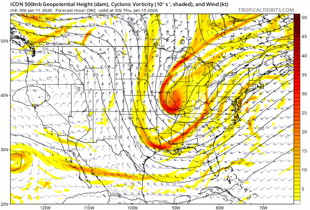
Fropa on the Icon.
-
The same northern stream issues we've had for a while now. It's too far east and can't phase, so no storm can come up the coast. Also pretty much ruins the chances for the storm after that too, everything is shunted too far east.
-
A lot of snow squall warnings on the Allegheny Front and Laurel Highlands. Maybe we get something this afternoon?
-

E PA/NJ/DE Winter 2025-26 Obs/Discussion
mattinpa replied to LVblizzard's topic in Philadelphia Region
I’m not yet. But even a little snow after this warm break would be nice. -

January 2026 regional war/obs/disco thread
dryslot replied to Baroclinic Zone's topic in New England
Last n9ight was basically a coating, Still watching the 16-19th for something more significant. -
RGEM obviously wouldn't work out but it did trend to the NS diving down more SW. Can't believe we're already at "extrapolate the mesoscales" for this lol.\ Edit: Also the RRFS A digs more thru 64hrs. But my read on that model so far is... not good? Am I imagining that?
-
New Hampshire? I was referring to central New Haven.
-
The big storm is most likely off the table for next weekend. No 50 50 and lack of blocking. Hope for a weak storm at this point.
-
Yesterday, JFK Airport, LaGuardia Airport, and Newark all had highs of 53°. That followed their having identical highs of 54° a day earlier. The last time all three sites had identical highs on two consecutive days was November 11-12, 2025 when the highs were 42° and 51° respectively.
-
That wind is a blowing! .
-
Forget about a big storm. No 50 50 and no blocking. Hope for a few inches ( if that)
-
Why are you acting like a weenie ? You are a meteorologist. Act like one.
-
We have a few flurries here


