All Activity
- Past hour
-
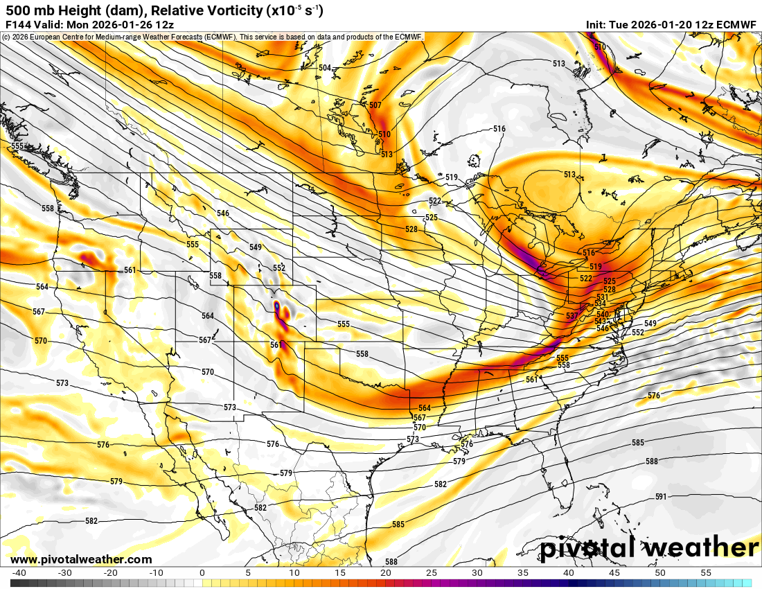
Not sure what the ratio of freezing rain and sleet would be in this given scenario but 12z EURO with monster FRZRN totals
-

January 2026 regional war/obs/disco thread
vortex95 replied to Baroclinic Zone's topic in New England
That evening when I heard on the wx radio that LGA has TS+, I said, "no way it can be tucked that far NW and not get BOS!!!" -


-
That was an I-40 special. Knoxville also had around 1 inch of ice from it. It was snow and sleet here, we had about 6 or 7 inches combined. Southern Kentucky has 12+ inches of snow.
-

Possible Record Breaking Cold + Snow 1/25 - 1/26
MANDA replied to TriPol's topic in New York City Metro
I believe you but that is an absurd statement for them to make. -
I only count 7 fairly truly devastating misses to the south. 14% of disaster, what could go wrong?
-

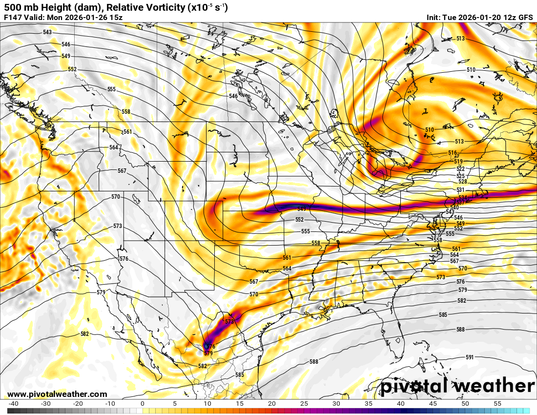
January 2026 regional war/obs/disco thread
CoastalWx replied to Baroclinic Zone's topic in New England
I was comparing 24 hour QPF and it looked a slight bump north to me. I didn’t combine total QPF because there’s some stuff between now and then that could be noise. -

2025-2026 Fall/Winter Mountain Thread
Maggie Valley Steve replied to Buckethead's topic in Southeastern States
It's a tough and thankless job that requires a lot of time if you really care. Thank you Michelle for all you do and especially after John passed away. -
 TriadTom_wxm changed their profile photo
 -
Make America Great Again and root for the GFS. Oh say can you see by the dawns early light…
-
Copy paste 9 (just extend to the East)
-
the key take away (1:11 update) .WHAT HAS CHANGED... Confidence continues to increase for a storm system to affect the area this weekend. Chances for accumulating snow and ice accordingly have increased compared to the previous forecast.
-

Possible Record Breaking Cold + Snow 1/25 - 1/26
NEG NAO replied to TriPol's topic in New York City Metro
FYI a few of the more reliable METS are even mentioning 20:1 around the metro. -
Possible Record Breaking Cold + Snow 1/25 - 1/26
MANDA replied to TriPol's topic in New York City Metro
Yep, about 20 model cycles to go. I would start to look for some sort of consistency and trends starting with the 12Z runs tomorrow to get an idea of where we stand. At that point (12Z tomorrow) we'll be within about 96 hours of the event. The better models (CMC/EURO/EURO AI) should start to have a better handle on things. Expect the GFS to flop around for who knows how long. I give no credence to that model no matter what it shows. It is bottom of the barrel. We might even want to start the baseline at 00Z tonight and see how things move from there. -

January 25-26 Winter Storm Potential
Ralph Wiggum replied to Ralph Wiggum's topic in Philadelphia Region
Completely agreed. Probably wont end up a HECS, that would be mega rare in a Nina. But a MECS is clearly on the table and I dont think a single one of us would have scoffed at this potential going into a Nina winter. I always say keep expectations low. -
How much ice for metro ATL? An inch?
-
In Greenville, SC....this is a big Booooooo
-

2025-2026 Fall/Winter Mountain Thread
buckeyefan1 replied to Buckethead's topic in Southeastern States
bx and rjay will drive by when they can, but there’s not many of us left who can or will -
I knew the northern stream would find a way to kick us in the nads again
-
And northern Middle TN as well. The southern adjustment gives me some added confidence.
-

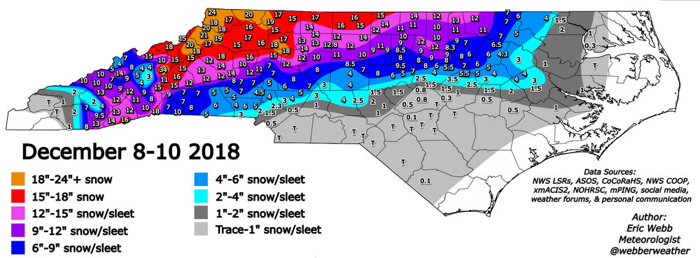
January 25/26 Jimbo Back Surgery Storm
NorthHillsWx replied to Jimbo!'s topic in Southeastern States
2018 all over again. Wake county was 8-10 inched on north end and nothing on south end -

Let’s talk winter!! Ohio and surrounding states!! 24'-25'
buckeye replied to buckeye's topic in Lakes/Ohio Valley
that only happens when we're in the bullseye....when the system is progged south of us there's no such thing as nw trend -

Texas 2026 Discussion/Observations
aggiegeog replied to Stx_Thunder's topic in Central/Western States
That was mostly sleet and there is a chance this could be mostly sleet though I do think for DFW this is looking like a bit of freezing rain Friday shifting towards sleet by late Friday. By Saturday afternoon and into Sunday DFW should be mostly snow. -
true
-

Possible Record Breaking Cold + Snow 1/25 - 1/26
eduggs replied to TriPol's topic in New York City Metro
12:1 is a good first guess for ratios IMO. Interior, mountainous regions get great ratios because they get great lift combined with cold. High ratio snow along the coastal plain is usually confined to snow squalls and heavy banding. Long-duration light-moderate snow might not coincide with enough lift in the snowgrowth zone to get higher ratios. Locking in 15:1 could lead to disappointment. -
Let’s talk winter!! Ohio and surrounding states!! 24'-25'
buckeye replied to buckeye's topic in Lakes/Ohio Valley
Still about 4 days out from depicted start of snow. That's an eternity when you have to deal with a northern stream feature interacting with a sw feature and a pv. Really need that sw to phase in better with the ns dropping down, and we know how that always seems to go. Did notice that HP was weaker and further north as the system rolled east on the euro. That's really what 'saved' us, and offset the weaker phasing and allowed the precip to still come further north. No feeling in my gut on this one. I can absolutely see the phasing falling apart leading to a 12zgfs-esque solution. All it takes would be the ns to speed up and the sw to hang back....that seems to be a common scenario over the last several winters, (failed phasing with a quicker ns). Still, the option for something bigger is definitely on the table too, especially with the temps during the snowfall leading to high ratios. I think one fail option we can take off the table...wtod Either way, this type of system is fun to track on the modeling.