All Activity
- Today
-
You rang.
-

December 2025 regional war/obs/disco thread
WinterWolf replied to Torch Tiger's topic in New England
Thank you for the reasonable post. -

Winter cancelled/uncancelled banter 25/26
coastalplainsnowman replied to Rjay's topic in New York City Metro
I figure this is as safe a place as any to post this. Hear me out.. was just watching Fox Weather for more than 3 minutes straight for the first time. I'll say this much - at 1AM they were covering - wait for it - weather. Talking about the Dec 26/27th threat, naming each of the models, presenting what each is showing. Not taking itself too seriously. Beats the other late night weather options of When Tornadoes Attack or some such nonsense on TWC, or the Accuweather wall to wall equivalent of Local on the 8s interspersed with mattress commercials. Just saying - not the worst thing to have on the telly in the background. What's the saying? Don't @ me bro... -

December 2025 Short/Medium Range Forecast Thread
John1122 replied to John1122's topic in Tennessee Valley
I think we'd all take this, with single digit cold pressing in behind the second clipper. -

E PA/NJ/DE Winter 2025-26 Obs/Discussion
LVblizzard replied to LVblizzard's topic in Philadelphia Region
I don’t really trust globals on the snow/mix line. We’ll have to wait another day or two for the hi-res models to come into range. What does look certain is that this will be an all or mostly frozen event for most of us. WWA just issued for Lehigh/Northampton counties for this morning. NWS expects 1-2” around here. -

Central PA Winter 25/26 Discussion and Obs
Festus replied to MAG5035's topic in Upstate New York/Pennsylvania
Per Millersville archive, we received 3.5" on December 26, 1947. Geez, getting fringed even way back then. -
December 2025 Short/Medium Range Forecast Thread
John1122 replied to John1122's topic in Tennessee Valley
The Canadian is just full blown winter, snow, ice box cold before New Years and after. +PNA looks beginning to appear and downstream we win. Old fashioned clipper/Siberian express on there. -

E PA/NJ/DE Winter 2025-26 Obs/Discussion
RedSky replied to LVblizzard's topic in Philadelphia Region
Boxing day looks like snow quickly going to ice -
The Euro and AIFS both look great! Most of the snow falls from 7 pm Friday to 7 am Sat. Just about every model is on board, but we're still 4 days away and much can still change...but I like where we are right now.
-

Central PA Winter 25/26 Discussion and Obs
Jns2183 replied to MAG5035's topic in Upstate New York/Pennsylvania
I wouldn't expect anything more than CAD doing its thing. Snow, no; Ice, yes Sent from my SM-S731U using Tapatalk -
Its crazy enough it was 59 like that 3 in-and-outs, a 4th would be a hair raiser. I'm getting the largest flakes of the season, some 2.5" in size but I wasn't out in it. Its lasting too, 1 hr of large but 10 mins of the giants. I'm just above freezing and near the rain line.
-
You're not gonna believe this. Buda's normal high/low is 59/42. It's 11.47pm Texas time. We have light south winds from the Gulf of Mexico. The temperature is 68 degrees, with a dewpoint of 66, it is quite humid out. I will definitely need to run my car A/C while running deliveries tonight. We are gonna have early May normals for Christmas, and maybe even for New Years'.
-
E PA/NJ/DE Winter 2025-26 Obs/Discussion
LVblizzard replied to LVblizzard's topic in Philadelphia Region
It’s virga. 0z hi-res models are slightly more aggressive for tomorrow. HRRR has 1-3” around I-78. Hoping to wake up to steady snow in the morning. -
How do things look rolling forward in terms of precip? Absolutely brutal start to the snow season in much of the West.
-
“I’ll take the under on it being 70 degrees on Christmas” - me to Ji a week ago Forecasted high of 46 on Christmas and a chance of wintry mix the day after with a high of 37 So much for a torch. Models look to be converging on the idea of possible winter revival by 1/5.. but we’ll see how that all looks a few days from now. One thing is for sure - models are struggling past D10. Just have to be patient and see how things unfold this winter. Posting “weeklies” and 384hr OP runs every 6 hours is pointless. Save yourself the headache.
-

December 2025 regional war/obs/disco thread
weathafella replied to Torch Tiger's topic in New England
I bet euro comes sizably north tonight -
December 2025 regional war/obs/disco thread
weathafella replied to Torch Tiger's topic in New England
Uncle is a nice hit for many of us. -
Cmc would have showed a huge snowstorm past 240. Models are really cold going forward. The warm pattern is gone.
-

Central PA Winter 25/26 Discussion and Obs
pasnownut replied to MAG5035's topic in Upstate New York/Pennsylvania
Yep. Look at 500's at timestamp of storm, and then paint a surface picture that youd think would logically fit. 0z GFS is not it to me, but as i've said a couple times, NAO is trending down as is AO, and that might be what is bring the surface maps slowly south as we get closer. Thats how I'm looking at it anyway. -
-
 Today was disc golf, shopping, tree decorating and dinner with our son and his wife then our biweekly poker night, so just getting back to looking at things. Will go with 1" in Metuchen, since the model consensus is more than the 0.5" the NWS gives me, and it just feels like things are trending better right before the storm, which I always like to see (like 12/14 and unlike most storms the last 4 winters). Let's go!
 -
Central PA Winter 25/26 Discussion and Obs
pasnownut replied to MAG5035's topic in Upstate New York/Pennsylvania
I just looked back over again, and I'm just not feeling it. Surface high isnt anchored, its scootin NE as SLP approaches. Thermals are on a razors edge for many southers, so we know how that cut feels. Otoh, SLP stays SE of Pa, so I think we'll need to see how much antecedent cold can hold when qpf arrives and how strong SLP gets. I'd root for a weaker slp, based on current evolution. JMO's -

December 2025 regional war/obs/disco thread
brooklynwx99 replied to Torch Tiger's topic in New England
lol at this trend in the Pacific. went from an AK trough of doom to legit +PNA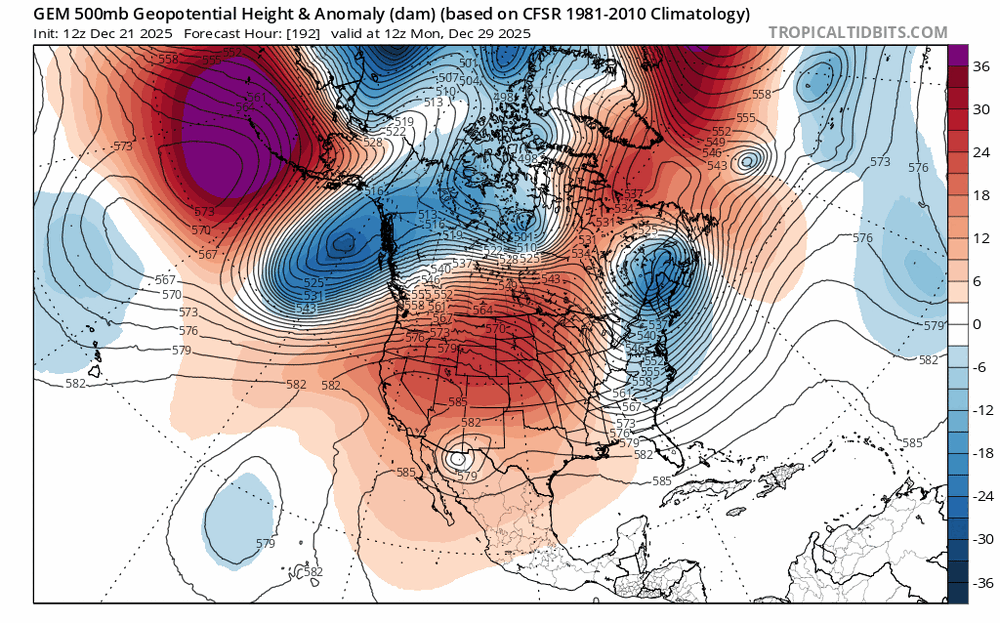
-
Still 4 days out but the most likely scenario seems to be a period of snow... Perhaps a thump of a few inches followed by sleet and ending as drizzle. Esp sw of the city. Cold air could hold on longer east and north of the city
-
Lets see if we can get Sunday's storm to shift south and colder


