All Activity
- Past hour
-
I don't know if there's any actual significant correlation between these two variables, but it seems like you need a deep and rapidly intensifying low pressure in order to have a successful backend "flash over". Mbs in the 990s, tilted mid levels, and rapid forward progression just won't cut it. Kind of a weird SWFE hybrid rather than a true coastal. Big warm nose etc...
-

12/3 Snow/Sleet/Mix Bag of Everything Discussion/OBS
Hurricane Agnes replied to Mikeymac5306's topic in Philadelphia Region
Finished up with a nice slow soaking of 1.09" of rain (had planted the last of my bulbs yesterday so they got rained in). Made it up to 40 as a high this afternoon once the precip. was over, after a low of 30 that happened just after midnight, after which the temp started slowly rising. Currently 34 with dp 33. -
3.0 to my NW. A hair less here.
-

December 2025 regional war/obs/disco thread
weatherwiz replied to Torch Tiger's topic in New England
Patterns like this you can tell in the weather social media world who just rips and reads SLP charts. All of a sudden the models at D3 will develop a QPF blob and people will go, "where did this come front, models didn't have this". Meanwhile that possibility was there for several-plus days. -
32/30 -FZRAPL 3.8" total accumulation with a light glaze on top now
-
This was a really weird sleet event. Not common you get sleet with a warm layer around 900mb, lol. But I agree it was probably not-fully melted flakes refreezing quickly into pellets.
-
Damn, great stuff tonight folks, thanks
-
That makes sense, but as Cape alluded to with the flow stretching the vorticity apart is it best for a developing low to be displaced from the strongest winds? I know that oftentimes the jet isn't able to "round the base" of a trough and once it does it indicates a matured/max developed storm and is that the logic behind it or am I mistaken?
-
Peeling paint off the windows now
-
3K Nam didn’t really have a sleet look. Probably half ass flakes that melted a bit and refroze.
-
Never ignore the NAM sniffing out a warm layer above the surface. Not sure anything else had sleet up this way.
-
Left exit and right entrance regions, where upper level flow diverges. Conservation of mass and surface boundary dictates that air must lift to replace the diverging flow.
-
All right that's enough of the gloating. Powderfreak South.
-

December 2025 regional war/obs/disco thread
WxWatcher007 replied to Torch Tiger's topic in New England
Yeah, we’re in good shape. We’re continuing to trend cold, and we’ll have ample shortwaves rolling into the region. Just give me chances. I don’t need to see D7-D5 nukes that trend to nothing. Danced that dance plenty. -
I guess I wasn't in that zone.
-
Nice event for your area Dave.
-
Hrrr doesn’t flip us back until after 11pm now. We’re prob not gonna get much late snows.
-
Back to all snow here
-
Just over 7 here with very light snow now.. was thinking 6 to 9 so not bad
-
Looks like 6.5” will be the final here
-
Hoping those echos get here otherwise we end with a wimper Sent from my SM-S921U using Tapatalk
-
CC not showing any signs of collapsing. Thing is cooked.
-
 1.38" from the ambient, but it's still raining here.
 -
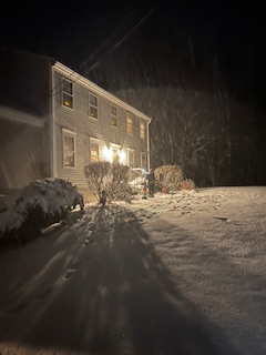
That’s gorgeous.
-
If I gambled I'd bet a lot on that being the outcome, lol


