All Activity
- Past hour
-
Get it. I’m on the metro and I refuse to do pbp on this damn iPhone.
-

Texas 2025 Discussion/Observations
Stx_Thunder replied to Stx_Thunder's topic in Central/Western States
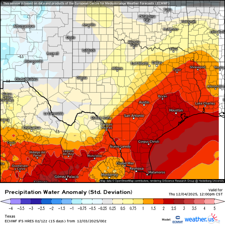
Euro & GFS have been consistent on this since last week, but 2+ in. precipitable water values (well above normal in December) near/over the coast starting late today ahead of the next SS trough out west and responding coastal Low. I'll be danged if we still have this late spring/early fall type moisture depth around the coast later this month or beginning of 2026. Especially with a warming ENSO (into EN territory) trend now back in the cards..
-
Root for your foothill brethren who missed to the west, south, east, and north last year.
-
This is the way. As i keep saying, this is house money. 2” would be fantastic and a mood booster around here. I just want a steady consistency in the models and fun tracking right now. Lol’d for real. We actually tried that with like 2 storms. We’d make a thread and shit would fall apart. Then a new thread and it trended in our favor. Then people started believing that worked. Fun times
-
So, someone can bitch... but we can't respond?? Makes no sense. If you're going to have one, you've got to have the other
-
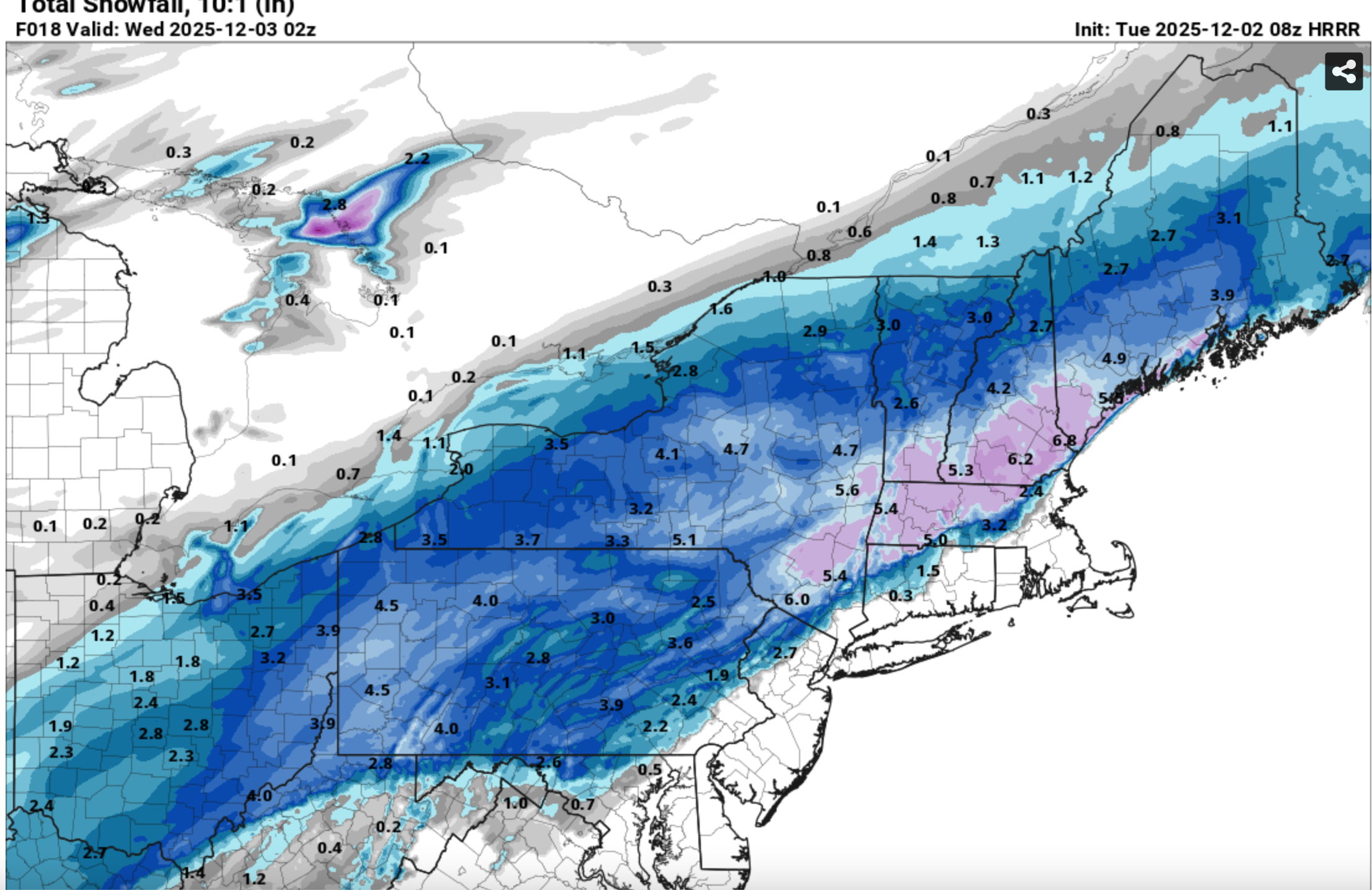
 And my last group of graphics: Check out the 08z/2 HRRR and the resultant snowfall... cherry picked that HRRR but its what I used for a local FB post. Scary good science (at least at times close in).

-
Early on, some positive changes out west on the NAM.
-
Just enough ZR and PL last night to make things miserable to clean up. Seems like every storm the past couple seasons is an icy mess and it's wearing me out.
-
Lol, that is definitely not true why they got snow. Oye.
-
But maybe they compacted? Maybe every 6 hrs tells the story.
-
I feel like they’ve been high before too
-
Cold bias in mind, but shows how rates can push the rain, snow, sleet line south. These temp boundaries can yield impressive banding relative to what the global models show, so something to keep in mind. A very tricky forecast with a boom and bust zone likely
-
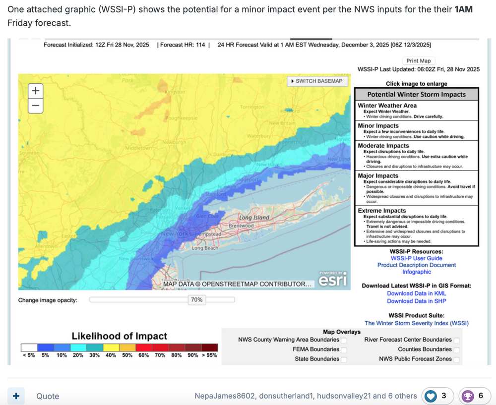
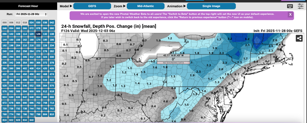
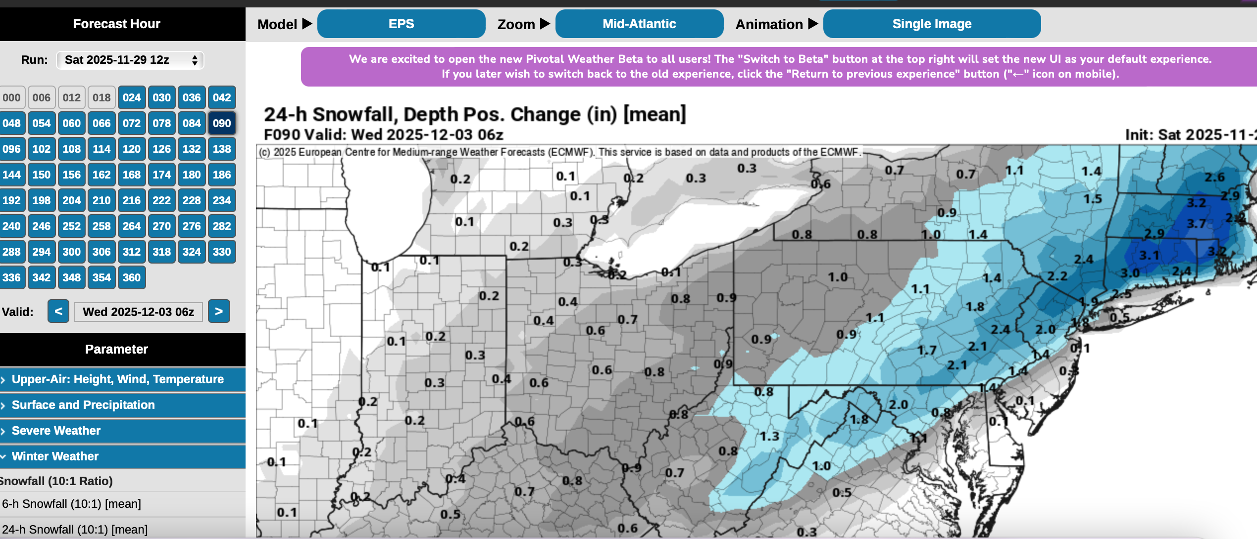
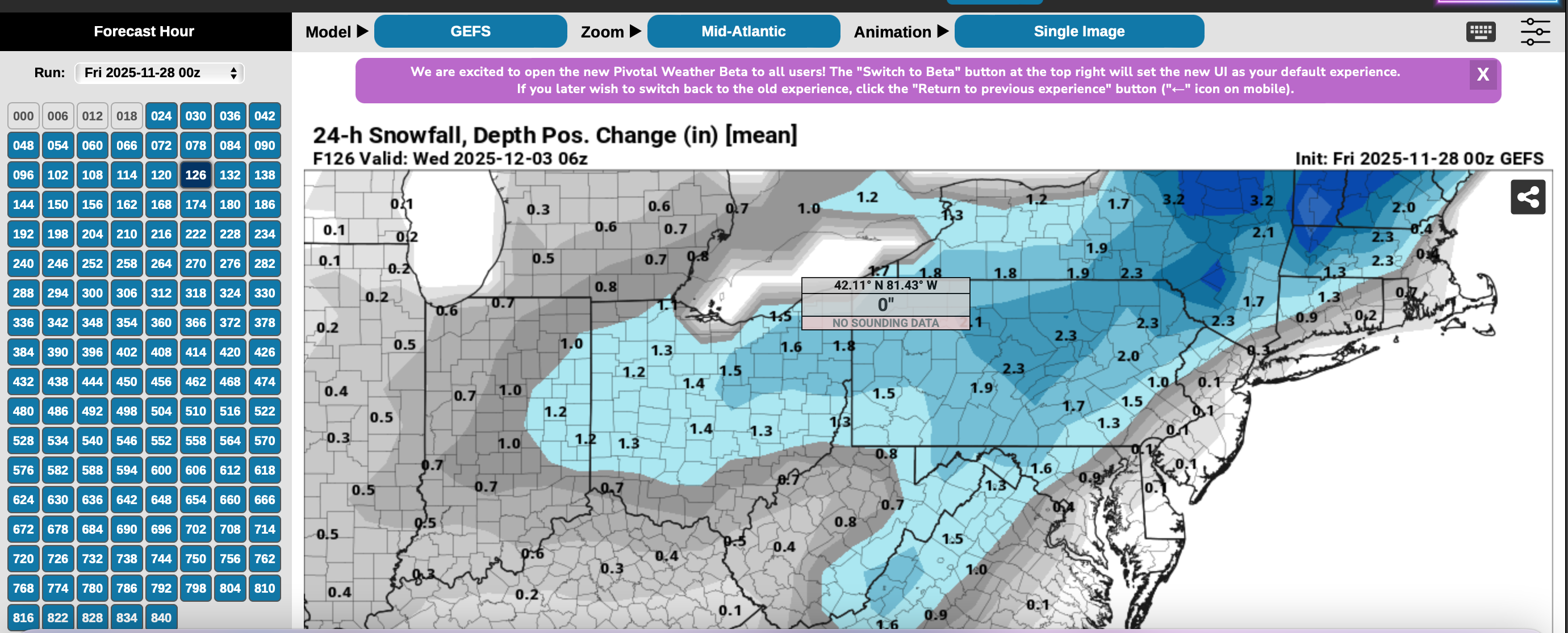
Indulge me for a moment on Thread reasoning despite the fact that all snow/ice was just inland from I95 and therefore missed the bulk of our members (no mPing sleet NYC). I say bulk of our members because I'm not sure we know how may are on here from coastal locations vs inland...I'm pretty sure its not 50 to 1. At Go time last Friday, a thread was made with the following basics. First the WSSI-P... MINOR impact. Yellow was the threat area and CORRECT with significant snow/ice during the morning-midday hours. I will use WSSI P yellow or higher probs for closer in threads during the future. We do have an ample amount of interior folk interested in winter activity. I hadn't heard anything negative from a moderator. So... the yellow thread area in the Friday guidance, even though a 40% threat for D5 is pretty decent for automated guidance. The numbers... plenty of beneficial rainfall for the coasts, AND the snowfall in the interior (doesn't show ice). Now, check the GEFS Modeled 24 hour Positive snow depth change!!!! against the the EPS same...except I could not go back to the Friday version, so I sued Saturday, but you see the EPS was HEAVIER AND WRONG. I hung may hat on what I thought was a better model. From my view: WSSI-P is a tool that should be used by all regarding impact. AND, the EPS (Ecmwf) is not as advanced as I thought it was.... This leaves the door open to more future choices... and am disspoiinted in EPS performance.


-
I'm way north of that desolate area...i'm thinking something like howmuchfurthernorthandwestdoifuckinghavetomovetogetsnow
-
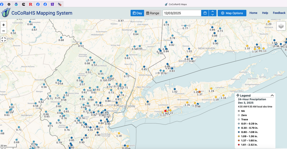
I did the same not realizing it's a new month. Ended with 1.98" for the day. Temp sitting at 58. Waiting on the front to come through. Had a morning low of 38. Looks like more rain coming in on Friday.
-
The HRRR at long range (take it with a grain of salt) looks a little better.
.thumb.png.2070401f40270b60f8b9df7b83e78e5d.png)
-

The Return of the 12/5 Snowstorm
SomeguyfromTakomaPark replied to SnowenOutThere's topic in Mid Atlantic
Per the Euro it is Friday morning. 10am-5pm type deal. Nice daytime snow. -
Tomorrow my forecast low is 13. I have no clue what the record might be around here.
-
Yeah I'm not expecting much if anything except for higher elevations from Avery County north. Another cold rain! Maybe the short range will start coming in colder but the CAD is super weak
-

Central PA Fall Discussions and Obs
canderson replied to ChescoWx's topic in Upstate New York/Pennsylvania
Sounds right. I had a bit more and to their NW. -
Are you making your new SN StephensCityGetsPrecip?
-
Feather dusting on the grass when I woke up
-
What time are we thinking a start time would be on Friday after 6 pm? or sooner?
-
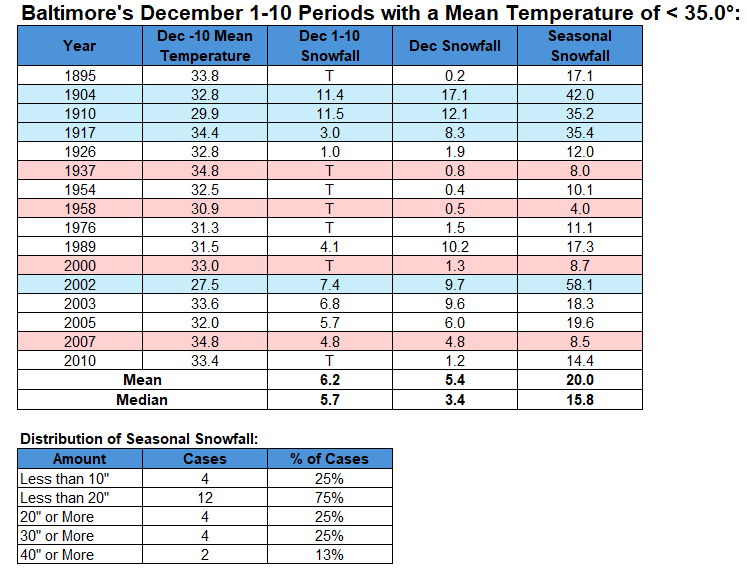
For Baltimore, the snowfall cases are far more mixed.
-
5.0" final. Beautiful morning out there for clearing driveway and pathways, frozen ground and fluffy snow ftw


.png.b6b5953a6b56480468a109777cef2cdd.png)


