All Activity
- Past hour
-
Ripping sun
-

January 2026 regional war/obs/disco thread
Typhoon Tip replied to Baroclinic Zone's topic in New England
Lot's of negative interference... It's been plaguing the 15/16 wave space, in every guidance really since the get go. Still, the EPS mean has steadily improved - just not a chunk move - yet ... but this at least a middling impact signaled here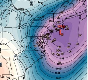
-
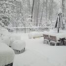
Ripping snow and graupel
-
This squall is wild! Went from sunny to clouds, wind, and blowing snow in a snap.
-
I'll never look at a snow squall the same way ever again. Just imagine the most intense squall you've ever seen. Add 2-3" per hour to that and make it last 7 hours and drop 40" of snow. That's a squall lol. That what I experienced last week. A shower of mix precip just moved through the lowlands.
-
Was only snowing for maybe 20s as this formed overhead. Little too late. Pretty, though. https://ibb.co/Q3ywXwyn
-
Snow / sleet squall in Columbia too. Briefly heavy.
-

January 2026 regional war/obs/disco thread
40/70 Benchmark replied to Baroclinic Zone's topic in New England
The PNA is still being undersold. -
Tons of reports of flurries all the way into the triad! Have to think with the wind these flurries are being blown for miles out of the foothills.
-
Well doggone. Snow squall in the tropics.
-
Sunny here!
-

January 2026 regional war/obs/disco thread
ORH_wxman replied to Baroclinic Zone's topic in New England
Shit or get off the pot time though for having a AN snow season for anyone who averages over about 45”. If we can score even a couple 4-8” type events, that would go a long way to keeping us in the game. EPS is showing PNA trying to spoke again late month so maybe another window for a coastal there. GEFS more lukewarm on that but it does have a pretty cold look with slight SE ridging. -
Cuz i deleted it.
-
Sleeting in Columbia
-
it was probably hidden or deleted
-
Eps went up with snowfall amounts and have more members amped . Think before you type or shut up.
-
January 2026 regional war/obs/disco thread
40/70 Benchmark replied to Baroclinic Zone's topic in New England
Absolutely. -
why does it say I don't have permission to see it ?
-
January 2026 regional war/obs/disco thread
40/70 Benchmark replied to Baroclinic Zone's topic in New England
I really don't think it matters. -
WB EPS totals Thursday/Friday/Friday
-
One flake to two flakes?
-
I got a look at all the EPS members and under 20 show some type of Norlun. But the locations are pretty variable. So the mean is an average of many more members which don’t really show a focused Norlun signal.
-
I just read a post from JB which pointed out 12z ICON at 180. Now, I don't really use the ICON much, but that run illustrates the concern which we mentioned here(well before JB) of the TPV getting trapped and sent south. I don't think that particular ICON solution comes to pass, but it could happen a few days later if HL blocking locks cold in over NA with that big EPO in place. I don't think the scenario of the TPV getting sent south(at least a part of it) is a given, but I would give it a 60/40 chance. Anyway, that ICON run is worth a look if just for kicks and giggles.
-
Definite uptick on mean snowfall on the 12z EPS for the Thurs/Fri event.
-
January 2026 regional war/obs/disco thread
ORH_wxman replied to Baroclinic Zone's topic in New England
That was the snowiest EPS run for New England in a while. Definitely some chances throughout those two weeks.