All Activity
- Past hour
-

E PA/NJ/DE Summer 2025 Obs/Discussion
RedSky replied to Hurricane Agnes's topic in Philadelphia Region
We G3 right now under the bright sun lol -
Damn man I need it not to be that
-
Agreed with this, great add.
-
I've come to find that they error goes in both directions ... They'll error too high on the regional totals ( actually), while down to a handful of towns and counties get Leominstered Over did the synoptics, but under did the local thunderstorm - but since the latter is inside the regional bounded area, it falsely props up the regional result. So two wrongs does make a right -
-

-
lol that's nothing, I had almost 11"
-
Wet
-
-
How does Saturday look
-
Wow. Ashland, Wisconsin - 32 yesterday morning to the upper 80s this afternoon. Talk about a big temperature swing. National Weather Service
-
Mid-range models are hinting at Friday Hoosier Alley. Wrong Region? Nah, ours is the best region and it's close, ha! Also unruly outflow boundaries south of progged could push that closer to our Mid-South, though probably not anything rotating. Better shear is Hoosier Alley. SPC hints at it in their 4-8 day text but I agree it's a bit early for a 15% valid Friday. I just gotta talk weather. Ventured into the off-topic toilet bowl this morning. SOS!
- Today
-

2025-2026 ENSO
michsnowfreak replied to 40/70 Benchmark's topic in Weather Forecasting and Discussion
Its always ok to agree with some stuff and disagree with others. Thats pretty much where im at. I do hope nyc sees some good winters soon, but obviously im more concerned with what goes on in SE Michigan and im still liking 2025-26 a lot at this early stage. I like that this thread sometimes strays OT (but not necessarily TOO OT lol) because I really look at it as an all encompassing "thoughts for next winter" thread rather than JUST Enso. But I do feel like different regions definitely have different goals in mind. NYC folks seem to really be into the final snowfall number. And while that certainly interests me, Im more about how the winter is going to act as a whole. Its like one big puzzle. The timing and length of different patterns will really dictate what kind of winter it is, and especially how the general public perceives it, moreso than what that final number is following the last snowfall, likely in April 2026. -
Well lookie what we have here…
-
That doesn't seem likely since the fires haven't been burning that long and I would think any smoke thick enough to slow daytime heating would also reduce radiational cooling. I think it's just been a long time since we've seen a pattern that can deliver this cold and dry of an airmass in June. We've grown accustomed to what seems like consistent warmth and high dewpoints during the three summer months in recent years or even decades. However, history says this chilly type of airmass does happen sometimes in early June.
-
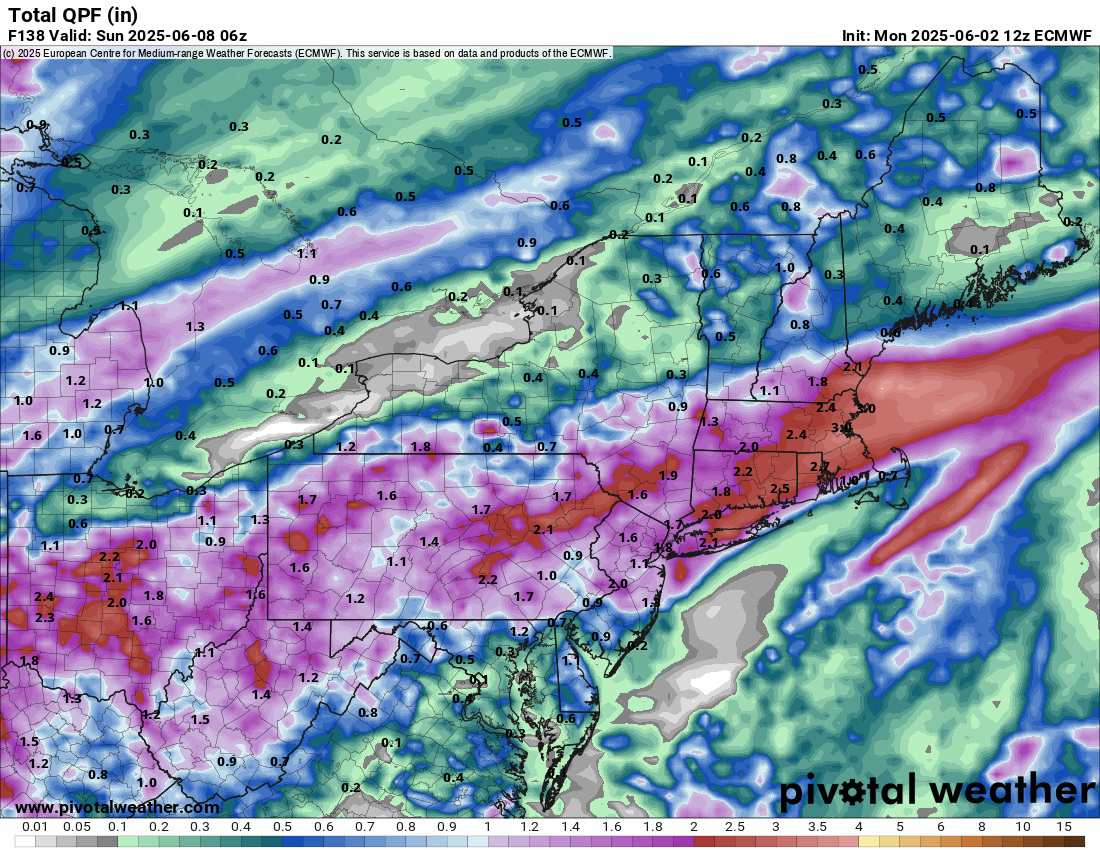
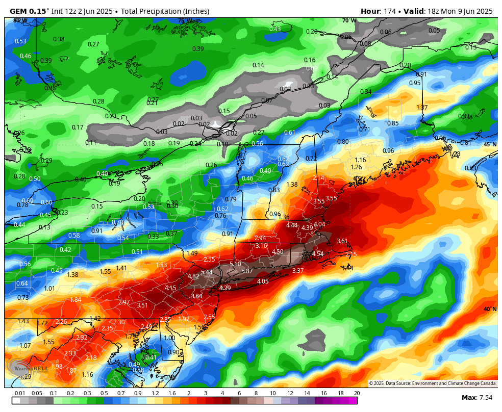
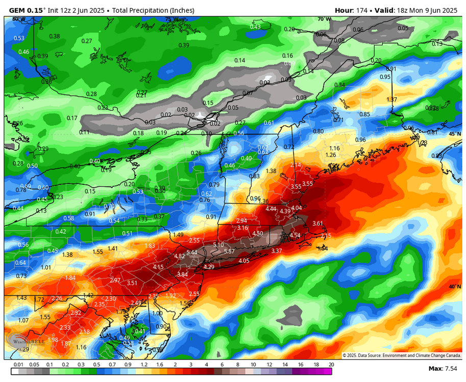
Euro soaks SNE now. Fook.
-
One thing to note as well for the Thursday - Saturday period is this is going to be much more convective so that opens up the door for some significant rainfall totals (at least locally)...models could certainly end up underdoing the extent of totals. Also, some areas will get significantly rainfall than forecast. Where the front becomes held up could be critical because there could be some major flood concerns up north.
-
Huh. Unless I was reading it wrong all the social media hype seemed to be for Sunday night.
-
Yeah but I guess I wasn't thinking government conspiracy.
-
aurora actually arrived around 2 AM saturday night. the show was all but over by Sunday evening
-
You got the right impression
-
Starts Friday, ends on Monday. Sounds about right. That would be hilarious. Synoptically stormy pattern this spring. ICON and GFS though are north and make NNE swallow the uzi.
-
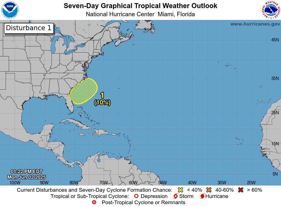
https://phys.org/news/2025-06-spain-highest-temperature.html https://phys.org/news/2025-06-uk-registers-warmest-weather.html
-
We can do without it, Would like to share the wealth.
-
Only one hourly record match at Dayton (31F, at 11pm). The current dewpoint is down to 30F, but it was as low as 25F at 1 pm on June 2, 1994. One bright spot, a lot of these years with record low dewpoints featured BIG time heat at some point in the month of June or later in the summertime (e.g., 1988/1994), so maybe that will be the case for 2025?
-
Nah this will be a NNE deal I think. I hope.