All Activity
- Past hour
-
33 in TAN. 44 here.
-
Weather apps?
-
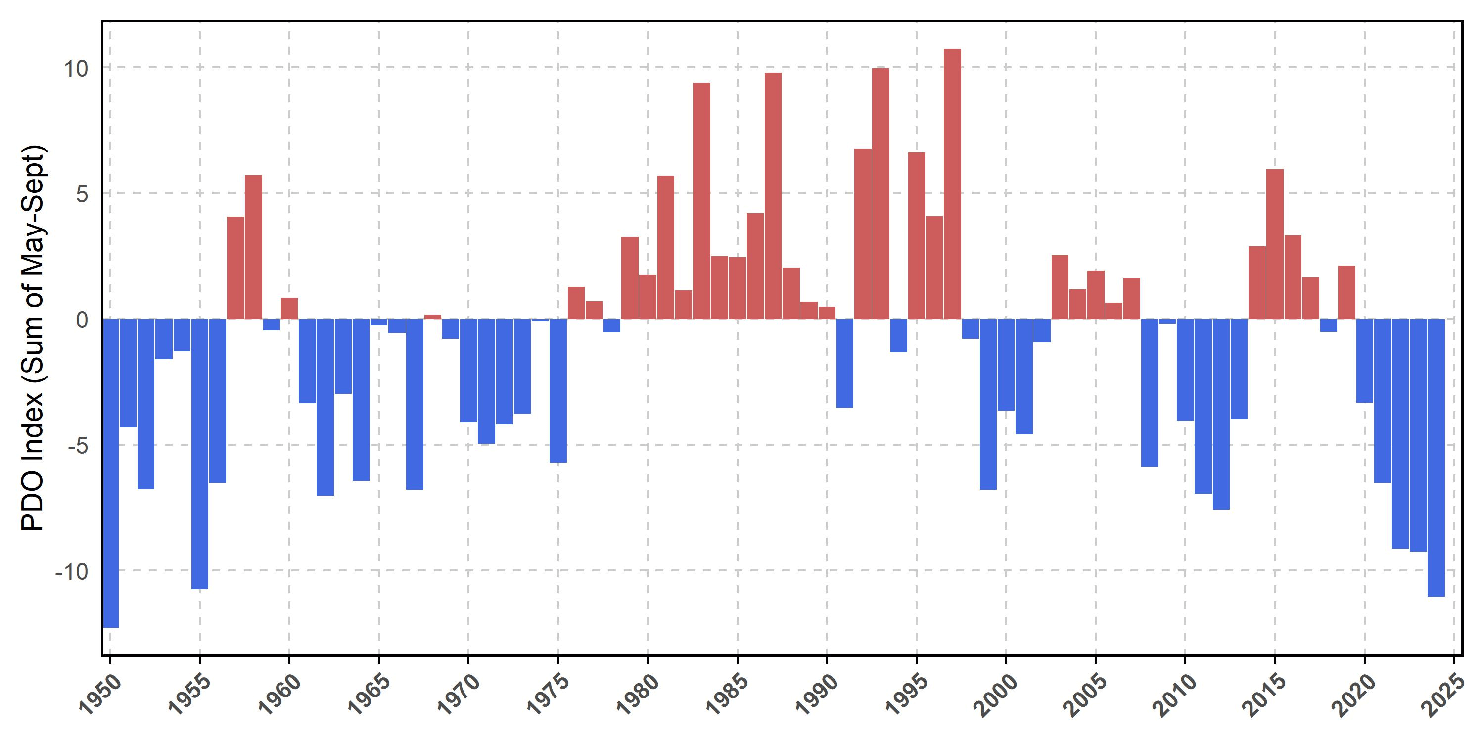
Thanks Chris, Keep in mind that that analysis is based on the Mantua et al PDO, which is more positive than NOAA’s, and is based on only May-Sept for whatever reason. But if they had done it based on NOAA, it would have been more negative. In addition, why not look at the entire year?
-
It just never really went calm here until near sunrise too…a pesky 5mph most of the night.
-
Underperformer here with only 0.38" overnight. Looks pretty dry the first half of May.
-
Monthly Dep: Site : Dep (AVG) / Rainfall (Normal) EWR: +2.7 (56.1) / 2.39 (N3.9) JFK: +2.9 (53.8) / 2.17 (N3.60) LGA" +1.7 (55.4) / 2.84 (N3.90) NYC: +1.6 (55.3) / 3.25 (N4.20)
-
33.3⁰ this morning, enough of this garbage now....the house got down to 62⁰ too
-
Hopefully not the dreaded north trend and congrats to places that don't need rain lol
-
Well partly sunny and mainly south of pike.
-
Records: Highs: EWR: 88 (2010) NYC: 87 (2001) LGA: 85 (2001) JFK: 81 (2001) Lows: EWR: 36 (1978) NYC: 35 (1880) LGA: 38 (1978) JFK: 38 (2008) Historical: 1854 - The Connecticut River reached a level of nearly twenty-nine feet at Hartford (the highest level of record up until that time). The record height was reached in the midst of a great New England flood which followed sixty-six hours of steady rain. (David Ludlum) 1857: The Washington Evening Star publishes the first US national weather summary using observations from volunteers to the Smithsonian Institution's cooperative network. 1933: An estimated F4 tornado struck Minden, Louisiana, killing 28 people and injuring 400 others. 500 homes were damaged or destroyed with $1.3 million in damage. 1935 - Snow, ice and sleet brought winter back to parts of southeast Minnesota. Minneapolis received three inches of snow to tie their May record which was established in 1892. (1st-2nd) (The Weather Channel) 1954 - The temperature at Polebridge MT dipped to 5 degrees below zero to esablish a state record for the month of May. (The Weather Channel) 1987 - Thunderstorms produced large hail and heavy rain in Texas. Baseball size hail pounded Dublin, and 3.75 inches of rain soaked Brady. (The National Weather Summary) (Storm Data) 1988 - Strong southerly winds ahead of a cold front crossing the Rocky Mountain Region gusted to 90 mph at Lamar CO. High winds created blinding dust storms in eastern Colorado, closing roads around Limon. (The National Weather Summary) (Storm Data) 1989 - Thunderstorms produced heavy rain in the southeastern U.S. Rainfall totals of 1.84 inches at Charlotte NC and 2.86 inches at Atlanta GA were records for the date. Strong thunderstorm winds uprooted trees in Twiggs County GA. (The National Weather Summary) (Storm Data) 1990 - Thunderstorms produced severe weather from northern Alabama to North Carolina. There were sixty-three reports of large hail or damaging winds, with hail four inches in diameter reported near Cartersville GA. Ten cities in the southeastern U.S. reported record high temperatures for the date as readings warmed into the 90s. Jacksonville FL reported a record high of 96 degrees. Late night thunderstorms over central Texas produced up to ten inches of rain in southern Kimble County and northern Edwards County. (The National Weather Summary) (Storm Data) 1999: Record, low temperatures for the date, were broken in the Deep South. Mobile, Alabama dropped to 46 degrees. Miami fell to 58; Miami Beach bottomed out at 61, and Vero Beach dropped to 47 degrees, all new records. Other stations in Florida also set record cold maximums for the date, including 61 at Jacksonville and Daytona Beach with 66 degrees.
-
It looks like 3-4 inches of rain for some of Pa. till next Wednesday. But i'm sure that will change with time.
-
54 / 37 off a chilly low of 43. Upper 60s to near 70 today in what will likely be the nicest day (sun - wise) till next Thu or Friday. A very warm Fri but it looks quite cloudy, any longer breakd gets the war m spots to mid 80s. Cut off low to our west this weekend keeps clouds and a warmer humid/southerly flow. Rain Sat/Sun from more scattered areas of showers, rain and some tstorms. Cutoff heads east Mon - Wed and latest forecasts bring 2- 4 inches of rain or more in the higher spots total from 5/3 - 5/8. Beyond there more near normal overall between 5/9 - 5/14. No strong warmth / ridging looking till mid month and post mid month.
-
Saturday maybe. Don't see it being sunny on Sunday.
-
52 degree's leaving home and a gorgeous 44 at work. That crisp air feels amazing.
-
chilly but no frost. 40 Massive solar loading yesterday so the battery was fully charged going into the night. Plus, with green up accelerating we're adding WV into the diurnal thermal state/cycle. These two factors probably helped the typical radiators from bottoming out lower.
-
No thread of 20% coverage 5" areal til this evening... if then. WPC has 4" bullseye over NNJ through 7 days. Helpful rains but spread out over days and dependent on back end bigger rains next Mon-Wed. Streams are low flow but urban problems could result. Major league Baseball games from Atlanta to Boston DC, Phil;ly, NYY likely to see some delays or cancels this weekend-early next week... and outdoor activity definitely impacted. For now through Monday morning... biggest rains ensemble modeled I95 northwestward (inland where widespread 1.5-2" anticipated). Thereafter the focus may shift... and that will be the driver to get us to 5+. That latter still has a fair amount of uncertainty. There has to be a map of rainfall deficits. I took a look back the past 9 months via HPRCC and it looks to me like our area has deficits of 4-9". There probably is better data out there that someone can share. I did look at DEP reservoir levels as of yesterday... unless I'm misinterpretating... we're closer to normal than I thought... did I misread less than 5% below normal?
-
While shorter PDO cycles in a warming climate may be a new concept to some on this forum, this has been a topic of interest in the climate community for a while now. It’s acknowledged that the decadal cycle broke down in 1998. This is why the PDO has been seeing such quick shifts from one phase to another since then. https://journals.ametsoc.org/view/journals/clim/29/16/jcli-d-15-0690.1.xml#:~:text=Abstract The impact of climate change on,in response to global warming or cooling. In the control simulations the model PDO has an approximately bidecadal peak. In a warmer climate the PDO time scale becomes shorter, changing from ~20 to ~12 yr. In a colder climate the time scale of the PDO increases to ~34 yr. Physically, global warming (cooling) enhances (weakens) ocean stratification. The increased (decreased) ocean stratification acts to increase (reduce) the phase speed of internal Rossby waves, thereby altering the time scale of the simulated PDO. https://www.fisheries.noaa.gov/west-coast/science-data/climate-and-atmospheric-indicators These decadal cycles broke down in late 1998 when the PDO entered a cold phase that lasted only five years. This cold phase was followed by a warm phase from 2003 to 2007 and an abrupt change to a cold phase from 2008 to 2013 (with a short interruption during the moderate El Niño in fall/winter 2009-2010). The PDO then switched phases again in 2014 and remained positive until 2018. This period coincided with a large marine heatwave and El Niño that negatively impacted the marine ecosystem in the NE Pacific during that time. Since 2020, the PDO has been consistently negative, reaching the most negative values since 1955 in both 2022 and 2023.
-
Will be sunny here, Saturday and part of Sunday.
-
To me a bad April is like 2018 when it was still snowing regularly almost until the 20th. However, a really good April needs at least one threat into this region (that verifies, not Monday's overhyped trash).
- Today
-
This was the 3rd warmest April on record for Long Island. Time Series Summary for ISLIP-LI MACARTHUR AP, NY - Month of Apr Click column heading to sort ascending, click again to sort descending. 1 2017 53.4 0 - 2010 53.4 0 2 2023 53.3 0 3 2025 52.8 0 4 2002 52.3 0 5 2012 52.2 0 6 1991 52.0 0 7 2019 51.9 0 8 1976 51.5 0 9 1974 51.4 0 10 2008 51.3 0
-
40F for the low, April to me flew by! Happy May Wiz hope you get your severe weather.
-

E PA/NJ/DE Spring 2025 Obs/Discussion
Albedoman replied to PhiEaglesfan712's topic in Philadelphia Region
OK Mt Holly, what do you guys have to say about this 40 degree diurnal temp change today? Woke up at 38 degrees this morning with a projected high of nearly 80 degrees? Wow have not seen this range in temps in a 12 hour time frame in a very long time on a nice day. Definitely living back in the CA Mojave desert environment in eastern PA from my younger days. -

E PA/NJ/DE Spring 2025 Obs/Discussion
PhiEaglesfan712 replied to PhiEaglesfan712's topic in Philadelphia Region
PHL finishes April with a 56.6 avg temp, which is 2.6 degrees above the 1981-2010 average. PHL is on track for a 5th straight spring with well above average temperatures. For the 2024-25 season, PHL finished with 8.1 inches of snow, which is the 7th time in 9 years (dating back to the 2016-17 season) that PHL finished with below average snowfall. 2017-18 is the only season in that timespan that had slightly above average snowfall, while 2020-21 had near average snowfall. -
Enjoy the sunshine today. Will be the last time we see it for 7 days
-

E PA/NJ/DE Spring 2025 Obs/Discussion
pl0k00n111 replied to PhiEaglesfan712's topic in Philadelphia Region
I am hoping the rain stops next Saturday, planning a outdoor party.