All Activity
- Past hour
-

Spooky Season (October Disco Thread)
CoastalWx replied to Prismshine Productions's topic in New England
Euro close to violence -
.45", 2.22" for the month.
-
0.05”. Better than nothing as we transition back to dry.
-
Maybe he's just talking about the low tide smell of hydrogen sulfide gas
-
Most of those really bad smells are a function of the sewage treatment plants draining into the bays in the SW Nassau area. The sewage treatment plant in East Rockaway and Long Beach next to the skating rink are a much more potent smell. Plus those plants are old and leak untreated sewage into the area from time to time. The hydrogen sulfide rotten egg smell from marshes doing their job is something that you get used to. Much of the time it’s in the background and not overpowering. But from time to time in the early morning during inversions it gets stronger. Though the smell usually goes away once the sun comes up and breaks the inversion. The other issue near the South Shore marshes has been locating landfills there. The one in Oceanside used to be across from the old TSS store which is now behind a shopping center. They finally closed that one years ago. Everyone used to have to roll up the car windows when driving by there. So marshes have mainly gotten a bad reputation by some not from their own natural processes but from all the pollution dumped into the areas. Driving through the marsh habitats on the parkways was one of may favorite drives when back on the South Shore.
-
0.29" here overnight... Pretty good considering.
-
Not surprising given it’s still D8+, but next weeks big storm still has a ton of uncertainty. 0z euro and 6z gfs skip over us entirely. Euro-AI gets us pretty good still though and EPS more or less agrees.
-
Trough over or near Japan this winter is key imho. It was showing up last year a lot leading to colder temps, step 1 in snow chances. Then we roll the dice on storm tracks.
-

Spooky Season (October Disco Thread)
Modfan2 replied to Prismshine Productions's topic in New England
About 4” of rain in the last two weeks here. -
.4”. Nice
-

Spooky Season (October Disco Thread)
ineedsnow replied to Prismshine Productions's topic in New England
We watch!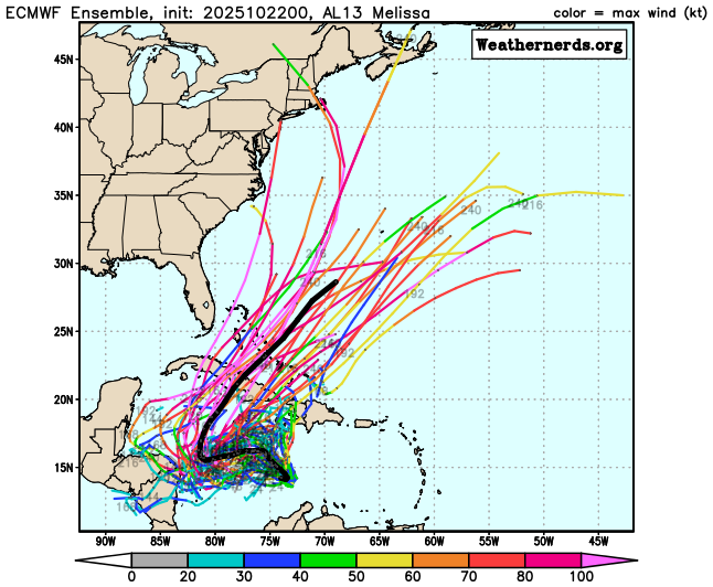
-
1.23” here so far. Another good soaker
-

Spooky Season (October Disco Thread)
512high replied to Prismshine Productions's topic in New England
.29" so far /49F -

2025 Atlantic Hurricane Season
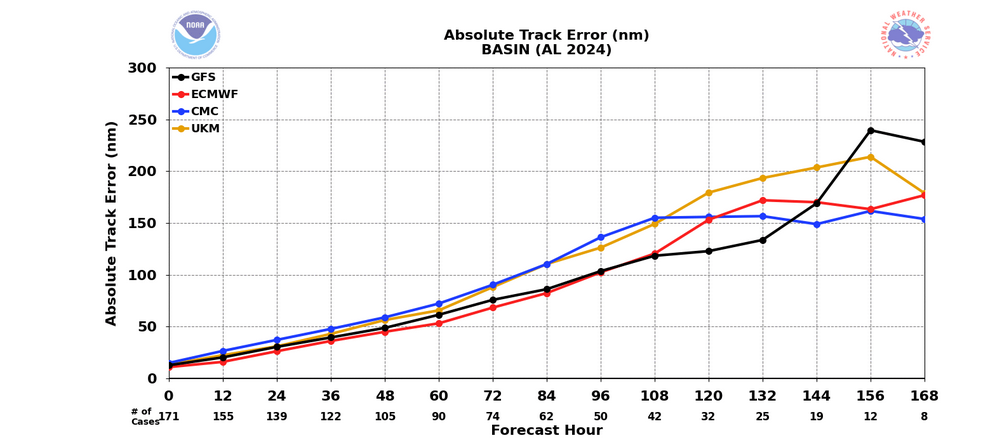
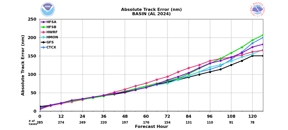
donsutherland1 replied to BarryStantonGBP's topic in Tropical Headquarters
For reference, model skill scores: Global Models: Ensembles: Hurricane Models: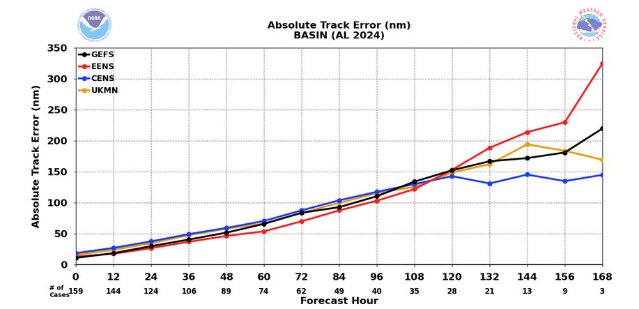
-
Also...Canadian block continues through the first week of Nov, and maybe we evolve to a positive PNA by Nov 5???
-
yeah feels like our luck has run out and the seasonal switch has been flipped
-
Good morning all, It is a good morning if we can partake in this forum... Widespread beneficial rainfall occurred overnight...into dawn, generally 0.2 to as much as 0.6, from what I can tell. The additional rain we didnt get Sunday night... Regarding what I think are errant 00z/22 CMCE and GEFS runs, the EPS and EPS AI continue on the path of a beneficial 1/4"-2" rainfall for our entire subforum around 10/29-30 or possibly split events 10/29-30 and 11/2-3. No thread on October rainfall equal or exceeding October norm due to very large disagreement between global ensembles. If the ECAI backs off the next couple days then I have to accept a rare win for the GEFS. I'm still always looking at CMCE but in my mind, it hasn't performed very well this year, especially beyond 24 hours. For now, I anticipate modeling to gradually migrate to a northwestward shift and back to the CPC 10/21 3PM moderate risk of heavy rainfall for the entire mid Atlantic coast 10/29-31 Also, all ensemble modeling is offering the first seasonal coatings of snow to the higher terrains of upstate NY and New England. Head into the storm with a steady hand until consistent cyclic evidence directs a change of course (drier).
-

Spooky Season (October Disco Thread)
dendrite replied to Prismshine Productions's topic in New England
Lots of brighbanding on radar too. ‘Tis the season. -
Spooky Season (October Disco Thread)
dendrite replied to Prismshine Productions's topic in New England
Most of the rain just missed to the west of here overnight….meh 0.25” and letting up. Gene is pushing 1”. - Today
-
Yeah you're right about that. Hopefully it is a larger shift rather than a blip.
-

Spooky Season (October Disco Thread)
kdxken replied to Prismshine Productions's topic in New England
Quick half inch here. Was coming down. Woke me up. -

Spooky Season (October Disco Thread)
HoarfrostHubb replied to Prismshine Productions's topic in New England
0.40” so far. Not bad -
Spooky Season (October Disco Thread)
kdxken replied to Prismshine Productions's topic in New England
Big time -
Could argue the switch to highs in the 40’s and 50’s this week is a bit of surprise and a shock to the system.
-

Central PA Fall Discussions and Obs
Mount Joy Snowman replied to ChescoWx's topic in Upstate New York/Pennsylvania
Low of 49 and .16” of rainfall.


