All Activity
- Past hour
-
It's also much easier to get warm with fire and cloths and shelter than it is to cool off when off the grid like a lot of the world's population.
-
I don't even want to describe the ride to work. Nothing in fuquay....got to crossroads and it went crazy...around 7:30am....I did not expect it. It took me 1.5 hours to get to Wade Park. It's a normal 35 minutes. I was driving through 4 to 6 inches of water at times...I got to work and looked at the radar and turned around and went home! Lol...I cannot wait to see the totals!
-
Open wide and say aaah?
- Today
-
2025-2026 ENSO
PhiEaglesfan712 replied to 40/70 Benchmark's topic in Weather Forecasting and Discussion
Yeah, if it was early June, I would have entertained the thought of an active Atlantic hurricane season. But we're now in early August. If we were going to have an active hurricane season, we would have seen something by now. (Even last year we had Beryl.) Instead, we are at about 2.5 ACE. Yes, I can see a big storm like Hurricane Andrew hitting at some point in the season, but that will be an outlier on the season, just as Andrew was in 1992 (another year that was very active in the Pacific, not so much in the Atlantic). For the most part, the Pacific is going to be active, and the Atlantic will be rather quiet. We're close to halfway on the hurricane season. The tiger isn't going to change stripes at this point in the season. 155 ACE has very low probability, and would be like if the Rockies made the playoffs this year. -
Occasional Thoughts on Climate Change
TheClimateChanger replied to donsutherland1's topic in Climate Change
Evening notes: -
There are no legit New England hurricane hits on the ensembles.
-
Rain has finally moved in. Picked up .42" so far.
-

2025 Atlantic Hurricane Season
BarryStantonGBP replied to BarryStantonGBP's topic in Tropical Headquarters
I mean, the switch flipped somewhat early this year -
2025-2026 ENSO
so_whats_happening replied to 40/70 Benchmark's topic in Weather Forecasting and Discussion
Legitimately if this had not started out as one of the lowest winter time volumes recorded this would have been an amazing retention year. The pattern was damn near perfect to lock in ice and cooler temps. The biggest help has been the lack of Canadian warmth up to the Archipelago. I don't even think the NW passage will open this year given we have about 3-4 weeks left of melt, unless this pattern completely flips on us. -
I'm ready for Blizzard Warnings already lol
-

2025 Atlantic Hurricane Season
Floydbuster replied to BarryStantonGBP's topic in Tropical Headquarters
Some of the accounts on weather platforms are getting too caviler and cocky in their eyerolls about the GFS. We are in August during what should be a favorable MJO phase and *unlike last year* models show a ton of activity in the coming weeks. The fact that model runs from the GFS to the EURO have shown significant hurricanes after mid August is very troublesome, especially since they have been consistent. Be ready, it is on the way. -
oh wow, radar says Jonesville next to Hillsdale got 3-5". That's insane from such a random shower type of a weather pattern!
-

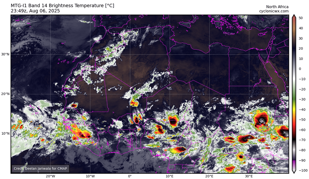
TROPICAL WAVE LOCATED IN CHAD, AFRICA (NOT 96L)
BarryStantonGBP replied to BarryStantonGBP's topic in Tropical Headquarters
oui oui baguette -

SE Area of Interest--10% two day, 30% five day odds
BarryStantonGBP replied to WxWatcher007's topic in Tropical Headquarters
Are you leaning for or against TC genesis? -
Cuba looks like a crooked nose in between two crazy eyes. Too bad it couldn't be some dumb twin names like Hurricane Bert and Ernie.


.thumb.png.4150b06c63a21f61052e47a612bf1818.png)


